

Good morning bloggers,
The KSHB-41 Winter Forecast Will Be Issued Thursday! It will be on at 6:30 PM in our Winter Weather Special!
Where is winter? Well, It isn't even December yet:
- Meteorological Winter begins December 1st (December 1 - February 28)
- Astronomical Winter begins December 21st (December 21 - March 20)
So, anyway you look at it, it is still Fall today. So, why not end Fall with a 71 degree day? It may reach that number this afternoon. This entire week will be mild, and then a major change and shift in the pattern is expected by next week.
The average high temperature will drop from 48° to 46° in the next seven days. Look at the forecast I showed last night at 10 PM!

Where is the Arctic Air? Take a look:

Oh, there it is - way up there! This map above shows the forecast for later this week. There are major changes showing up around the end of next weekend, right around the time we get to Sunday Night Football.
The Arctic Oscillation (AO) & The North Atlantic Oscillation (NAO)
The AO & NAO are surging into positive territory. Take a look:

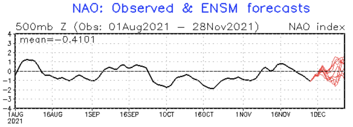
What does this mean? When these indexes go into higher positive territory, the jet stream often gets weaker and the energy gets spread out and is farther north. This will often end up indicating that any Arctic air will be held way to the north. And, this seems to be happening.

This is a unique weather pattern that is evolving before our eyes. We have never had a pattern before exactly like this. According to the LRC, every year is unique. This AO and NAO influence on this pattern is bothering me right now. If these indexes are positive all winter, then it will be a warm winter ahead. I am not seeing this, however, and based on what we have analyzed I am expecting these influences to shift more negative again. But, for now, it means we have a warm week ahead!
Another interesting big thing to monitor is the amount of snow that falls next month. This will go a long way to predicting the end of season snow total? We will discuss this much more later in the week when we have our winter weather special Thursday night at 6:30 PM. Look at these stats that show how important December is when it comes to the winter season total:

Kansas City has had one of it's snowiest winters, in fact both 2009/2010 and the 2010/2011 winters are in the top ten. And, KC had it's least snowiest winter, and four of the bottom ten since the 1880s, with 3.9" of snow in the 2011/2012 winter. Look how important December is for these annual totals:
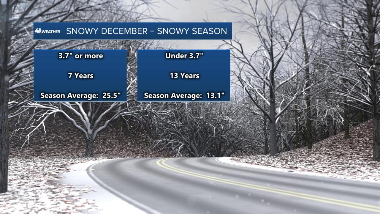
I analyzed the past 20 winters for these results. There were 7 winters that had 3.7" of snow or more in December, and 13 winters that had under 3.7" of snow in December. In the snowier Decembers, KC averaged 25.5" of snow, and in the 13 winters with under 3.7" during December, KC averaged only 13.1". So, what happens in next month will go a long way to telling whether or not it will be a snowy winter ahead!
Thank you for sharing in this weather experience, and spending a few minutes of your day reading the weather blog. Have a great start to your week.
Gary
