

Good Saturday bloggers,
It is not unusual to see rain in January. It is unusual to see a rainstorm in January. Today is one of those unusual January weather days as a rainstorm tracks across the region.
As of 8 AM Saturday a large area of rain was moving north from Oklahoma and southern Kansas. It is also rare to see all rain with no snow in a January storm. Now, that will change later today.
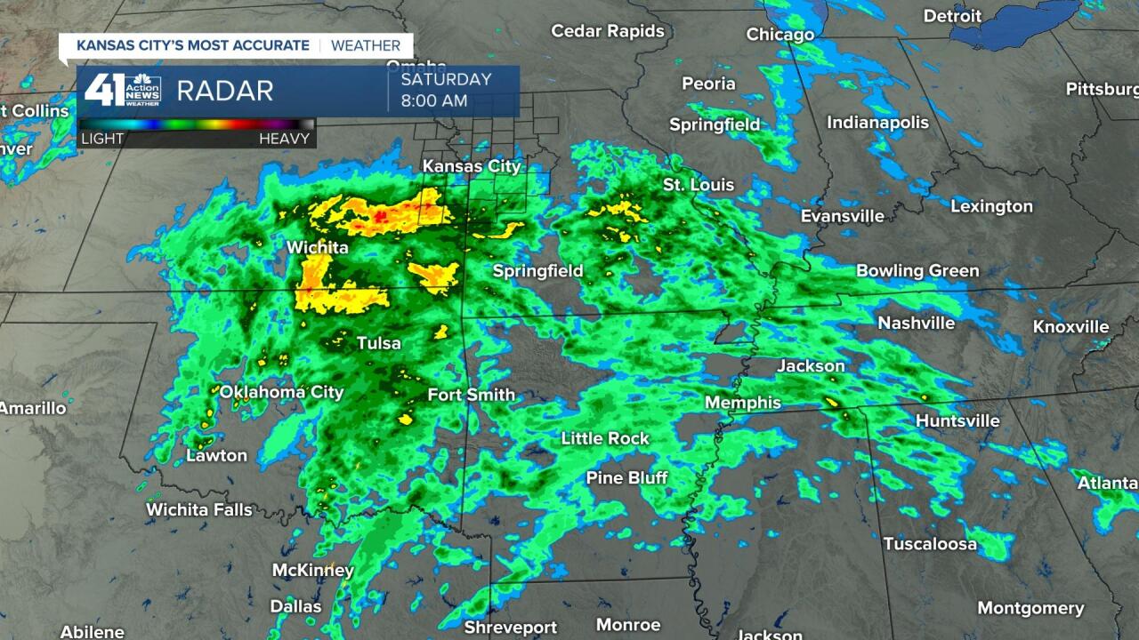
SATURDAY 3 PM: We will still be seeing rain with a few heavy downpours. Highs today will be 45-50 with southeast to east winds 10-25 mph. The rain will be changing to snow from northern Iowa to southwest Indiana where a Winter Storm Warning is in effect, including Chicago. You can see a curl in the rain near Kansas City. That is the main storm and our significant rain will end once that moves by.

SATURDAY NIGHT: The main rain will end 7-9 PM, but we could still see a few rain showers that change to snow showers overnight. Colder air will be moving in on northwest winds 15-30 mph. Lows Sunday will be 30-35, but we do not expect it to be cold enough for black ice and we do not expect enough to snow to be an issue. We may see a few snowflakes.
Sunday will be cloudy, windy and cold with highs around 35. A few flurries are possible as well.

RAINFALL FORECAST: Most locations will see around 1" of rain. 1.07" is the average rainfall for January, so today we will see a months worth of rainfall. This is more than enough to wash off the salt and chemicals from the roads. And maybe get your car a free wash.

Drought conditions were trying to creep on on December 28th. Then, we had 1.19" of rain, melted ice/snow on the 29th. Since then we have been in a wet pattern. Snow has been light, but the other precipitation types have been plentiful.
Since December 29th we have seen 200% to 300% of our average rainfall. This time of year that is 2"-3" of rain. If we saw 200% to 300% of our average rainfall in June, that would be 12" to 18" of rain. After today we will move into the 300% to 400% of our average rainfall category.

SNOWFALL FORECAST: This storm will be producing snow later today into Sunday-Monday from Minnesota, Iowa east to NYC. Areas near and south of Chicago may see 10" to 15" of snow. It makes sense as we are seeing 1" of rain. If this was snow we would see 10". If you are planning travel to Chicago this weekend, expect major airport delays.

WEEKEND WEATHER TIMELINE: Rain, heavy at times, will continue until around 7 PM. Overnight it will be windy and colder with lows 30-35. A few rain and snow showers are possible, but roads will not get icy. Sunday will be cloudy, windy and cold with a few flurries.

A LOOK AHEAD: The sun returns Monday with highs around 40. Tuesday and Wednesday are calm days with highs in the 50s. Then, Thursday-Saturday we will see some potentially big wintry changes. Arctic air will be heading south as a storm system organizes in the southwest USA. We will be talking more about this in Sundays blog.
Have a great weekend and stay healthy.
