

11: 15 AM Update:
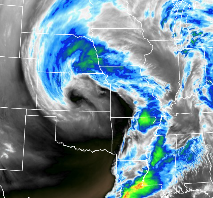
Good late morning or early afternoon! A rare cold front is moving through from the south. In the earlier blog entry I drew this in as a warm front, but it is actually the opposite. It is a cold front moving north around the occluded storm system. The cold front caught up to the warm front and, as you can see below, cooler air is south of the front.

Any risk of severe weather, which is very low anyway, will end with the passage of this cold front. The atmosphere will stablize just a bit, and the low risk of severe thunderstorms will shift to eastern Missouri and Iowa by mid-afternoon as this front is moving rather quickly.
Previous entry below:
Good morning bloggers,
Surviving The Storm, our spring weather special, is on at 6:30 PM Wednesday! I will be sharing with you the LRC prediction of the days we expect severe weather this spring. Today, the risk is very low. In fact, Kansas City is on the western edge of the risk area today, but areas to the northeast have a low end level 1 out of 5 risk.

The risks are very low end today. In fact, there is not even a slight risk anywhere. It is just too cool for anything serious to be expected. There are two marginal risks, what we call a level 1 out of 5 risk, of severe weather. One of them is near New Orleans, and the other one is over northeastern Missouri.

A surface low will be located near the Nebraska/Missouri/Kansas border and moving northeast around 3 PM this afternoon. If it was 75 degrees or warmer, this would be a much more significant risk. With this set up we will likely see the upper 50s to low 60s which is just not enough instability for anything more than this marginal risk. The best chance of a severe thunderstorm forming would be near and just north of that warm front, the red line. By the time the thunderstorms strengthen, they will likely be far north and east of KC. As always, however, we will certainly be monitoring this closely for any subtle changes.
There is another storm on the heals of this one. Kansas City once again had one of the lower rainfall totals in the entire region with only 0.07" as of 7 AM. There may be a few downpours and possibly a brief thunderstorm today, but many areas will not have measurable rain today. The next storm due in tomorrow evening has a chance of producing around 1/2" of rain. More on that storm later.
Kansas City Weather Time-Line:
- Today: Mostly cloudy with a chance of showers and possibly a thunderstorm. The chance of rain is 40%. High: 59°
- Tonight: Mostly cloudy windy and cooler. Southwest winds shifting to the west at 30 mph. Low: 44°
- Wednesday: Mostly cloudy with rain possible during the evening. Windy to start the day, and then the winds will become calm during the afternoon. High: 47°
Thank you for spending a few minutes of your day reading the weather blog. Have a great day and if any thunderstorms for we will let you know if anything serious develops. Stay with 41 Action News, & we'll keep you advised.
Gary
