

Good morning bloggers,
A series of strong storm systems continues to affect the nation. 3 feet of snow has fallen near Denver, CO burying that city with major flight cancellations. That storm affected us over the weekend with some rain and thunderstorms. There may be a few thunderstorms later this afternoon as well. There is a low end risk of any severe weather with today's set up due to how cool it is. We have a level 1 of 5 risk in our area for a few thunderstorms to form later this afternoon. If they do form, some hail will be likely as temperatures aloft are very cold.

Again, today's risk is a level 1 out of 5. In this risk type we really are not expecting thunderstorms to become severe. A severe thunderstorm is one that produces hail of at least the size of a quarter, or 1" in diameter. The risk increases by Wednesday over the southeastern United States, but KC will likely again be too cool for any of these more serious risks. Our risks of severe weather will be increasing in the next two to three weeks as warmer air returns.

This Storm So Far:
Well, let's begin with this impressive comma cloud with a huge Synoptic Scale Mid-Latitude Cyclone:

This storm followed the storm with the lightning from last week. So, we have had around an inch to two inches of rain from the past week. We are the target for 1 to 2 inches of rain to fall from the mid-week storm system. And, we will be updating that forecast as that storm approaches. The center of the storm was over Colorado where the tremendous amounts of snow fell. Kansas City was in the rain bands and around 1" of rain has fallen in KC. Heavier amounts of rain are more likely Tuesday night and Wednesday from our next storm system.
Today's Set Up:
This morning, there is a strong surface low that is all occuluded, which means that the cold front has overtaken the warm front, and the storm is vertically stacked. This means the upper level low is over the top of the surface low. The center of this system can be seen well over western Kansas this morning.

7 PM Forecast:

Thunderstorms are a possibility later this afternoon and evening. The risk of severe weather is very low as a result of how cool it will be, in the 50s this afternoon. We will still monitor this situation closely. This map above shows the center of this powerful storm is forecast to be near Kansas City at 7 PM this evening. This storm will be rapidly weakening in response to this......Look below:

The next major storm will be intensifying closer to Kansas City on Wednesday. Look at this cyclone forecast to be centered over Oklahoma Wednesday morning. This storm will produce a level 3 or 4 out of 5 risk of severe weather:
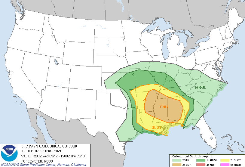
The LRC would strongly suggest that Alabama and Mississippi are the main risk areas. In fact, Jefferson county Alabama had an EF-3 tornado in the last LRC cycle, and they had another tornado in Jefferson county, AL in the LRC cycle before that, and this is a significant target again this week. The LRC can literally go down to county level. Let's see what happens with this system on Wednesday.
In Kansas City, it will once again be too cool for the severe weather risks in our area. But, there is a chance of snow on the back side of this system:
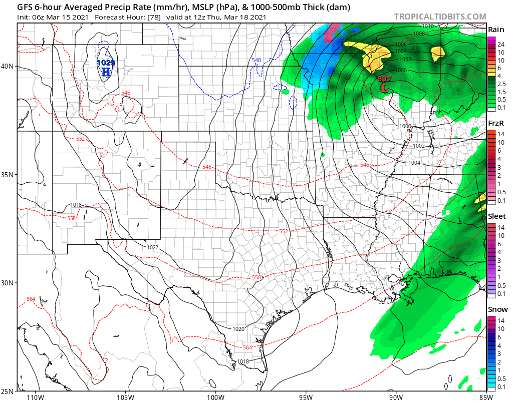
Notice the blue shade down to KC early Thursday. Right now, it appears it will be too warm for accumulation, and it is something we will be analyzing closely.
Kansas City Weather Forecast Time-Line:
- Today: Cloudy with a few showers likely. There is a chance of afternoon or evening thunderstorms with some hail possible if they do form. The chance of rain is 100% later today. High: 55°
- Tonight: Cloudy with light winds. Low: 41°
- Tuesday: Mostly cloudy. A light southeast to east breeze. High: 55°
- Wednesday: Cloudy with a 100% chance of rain. The rain may be heavy at times with a few thunderstorms. Windy: East to northeast winds 15-30 mph. High: 50°
- Thursday: The day may start with some snowflakes. Rain and snow ending before noon. High: 47°
Thank you for spending a few minutes of your day reading the Gabbing With Gary blog. We will be updating our forecast as the new data comes in today. Stay with 41 Action News, and we'll keep you advised. Have a great start to your week.
Gary
