


Good morning bloggers,
A Major Winter Storm will affect the Kansas City region on Saturday. The amount of snow depends significantly on the track of the Pacific storm system that is now moving across Mexico. This system will be moving fast and it will be near Kansas City by noon on Saturday. The track of this system is essential for the amount of sleet and snow that will accumulate. If the system tracks south of your location, you have a much better chance of higher totals, and if it tracks to your north, then you will have much less accumulation.
Model Snowfall Forecasts:
Here are the model snowfall forecasts for Liberty, MO (northern KC metro area), Olathe, KS (south KC metro area), and Maryville, MO (far northwestern Missouri):


Again, the track of the upper level storm is extremely important. Notice the European Model that had the highest amount in Liberty, MO. There was actually an 11" band from this European model near the north KC metro area. Why? They Euro tracked the storm near Olathe, and as a result produced the heavy band just north of it's track near Liberty, MO. Most of the other models track this system farther north.

Here is the raw weather data analysis. This disturbance is extremely important. If that X, I point at above, tracks south of your location, you will be in the heavy snow. If it tracks north of you, then you will not be in the heavy snow. Along and just north of this systems track will likely produce 2 to 3 inches of snow per hour rate. Imagine two hours of that rate. That will be 4 to 6 inches in around two hours, and I am expecting a band to form that will do this. The Euro has that band over KCI Airport. Other models have that a bit farther north. This is one of the things we will be tracking tonight and Saturday.

If it takes this track, then most of the KC metro would be in the heavy snow by noon Saturday. But, just a slightly farther north track and it will be less. For all of this to happen, we must have a blast of Arctic air. This is a huge ingredient. Well, look at what is now surging our way:

There is an Arctic Blast on the move and it is already on our doorstep. It will blast through later today. Temperatures will be crashing on New Year's Day down into the single digits. This is why we can rule out rain:

There may be some freezing rain, but the main types will likely be sleet and snow. Sleet is frozen rain, or ice pellets (frozen raindrops, that may have come from melting snow through a warmer layer as it falls).
At 2 AM, the storm is still out west and it will likely be dry until around 4 or 5 AM:

The sleet/snow changeover line will be moving southeast. The faster it changes over, the more snow you will get.
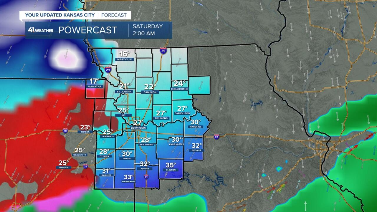
Forecast for Kansas City:
- Sunny today with increasing afternoon clouds. The cold front will move through by this evening. South winds shifting to the northwest later today. High: 57°
- Tonight: Dry through 2 AM. Freezing rain, sleet and snow, mostly sleet and snow will be moving in and increasing after 2 AM.
- Saturday: A winter storm will be in progress with some sleet accumulation below the snow accumulation. Total accumulations expected to be in the 2" to 5" range in KC with higher amounts north, and lower amounts south.
The models as they come out this morning:
- NAM (came in at 8:15 AM): This model had almost all sleet in KC until Saturday afternoon when it changed to light snow. Total snowfall 1", on top of some sleet.
- ICON (Due in at 9:15): It has 1" south to 4" north, and 8" northern Missouri
- GFS (Due in at 11 AM): This model has sleet and 1" of snow on top, yes, that is all it has after all of the runs with so much more
- Canadian (Due in at 11:30): 2" south Overland Park to 5" at KCI Airport
- European (Due in at 12:15 PM): It took a perfect track for our forecast to verify. This model has 2" to 5" from south to north across the city. There are a couple of heavier bands up north.
So, the first model in was rather odd, and it had very low snowfall totals in most areas except far northern Missouri. Let's see how the other models come in.
Watching these models come in with such low totals is yet another example of why KC is the most difficult place to predict the weather in the world. The GFS (American Model) just came out with real low sleet and snow totals. It has under 2" city wide, so it is something we will consider as we update our forecast. I need some more time to analyze.
Bottom line: Our forecast has been in the 2" to 5" range maximum, and this is still about what we are expecting.
Thank you for spending a few minutes of your day reading the weather blog and sharing in this weather experience. Have a great New Year's Eve! We will keep you updated.
Gary
