


Good Wednesday bloggers,
We are going to be in an active weather pattern the next ten days. Systems will track west to east across the USA from the Pacific Ocean. They will pound the west coast with another "Atmospheric River.". This means tremendous precipitation on top of the already soaked state. It is amazing how a three year drought ended in the last three months. The incredible rain and snow are good news for the long term water supply, but they are getting too much of a good thing. The rain and snow is coming so heavy, so fast.
RAIN/MELTED SNOW SINCE DECEMBER 8TH (LAST 90 DAYS):
We have seen 7.8" of rain/melted snow which is 3-4" above average. This has rid us of the drought. 25" of rain/melted snow has occurred in the Sierra Nevada, ridding then of drought as well. Arkansas and Louisiana have seen 15-25" and this has rid them of drought too. The one remaining really bad area in drought are the western Plains where they have seen 1" or less of rain, melted snow.

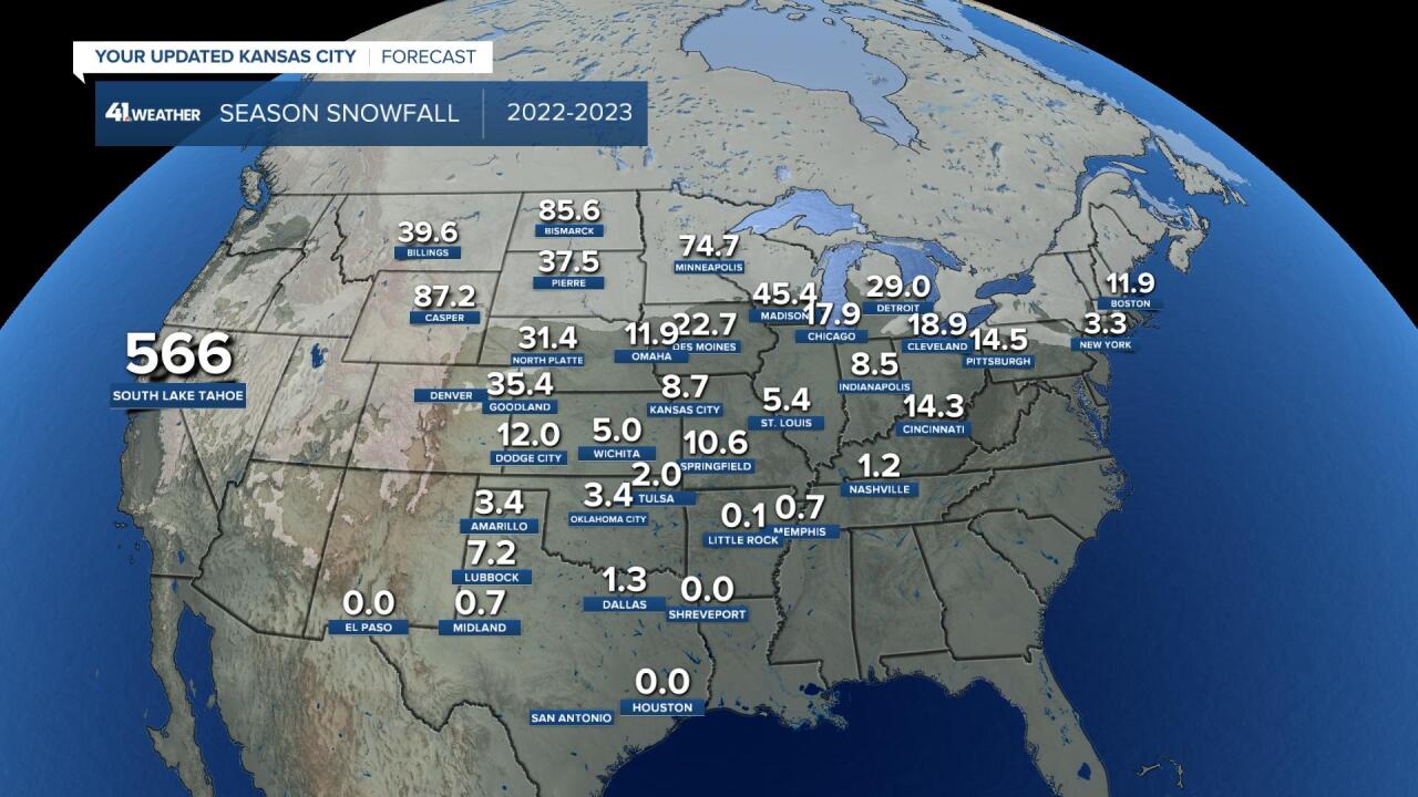
SNOWFALL THIS SEASON, 2022-23:
How much of the total precipitation has been snow? Keep in mind around 1" of rain is equivalent to 10" of snow.
Look at Lake Tahoe! There has been 566" (47 feet!) of snow at 8852 feet. 395" of snow has fallen at 7300 feet. We have seen 8.7" of snow but with having seen nearly 8" of rain, our precipitation has been 90% rain and about 10% snow. Note, the snowfall readings and equivalent precipitation measurements for Lake Tahoe are likely in different locations. So, it is hard to see how much precipitation has been rain and snow. Bottom line...It has been a lot of both.
The Dakotas and Minnesota have seen 70-85" of snow. That is way above average for those locations.
SNOWFALL FORECAST THE NEXT 10 DAYS:
The active weather pattern will deliver a new 5-6 feet of snow to the Sierra Nevada! 5-6 feet of snow seems low compared to the 47 feet they have seen. This will still be good news for the reservoirs.
12"-18" of snow is possible from Iowa to the Dakotas. We are in the less than 1" category. There is a system around the 17th that we will watch for one of our last snow chances of the season.

RAINFALL FORECAST THE NEXT 10 DAYS:
10"-20" of rain/melted snow equivalent is likely in California. And, here is where California may have real issues. The snow levels with an "Atmospheric River" rise as they have much warm air with them. So, it may rain below 8000 feet. Well, there are several feet of snow on the ground. When, you add the torrential rain on top of that snow, you will get a rapid snow melt. This has the potential to cause catastrophic flooding. Stay tuned!
We are in the 1"-2" rainfall category. This follows our winter pattern. As we will see 1-2" of rain and 1" or no snow. If we see 1" of rain and get 1" of snow. Our 10% of precipitation being snow continues.

Let's look closer at our region. Our area will see three periods of precipitation as we track three storm systems.
SYSTEM #1, TODAY-THURSDAY:
We still have the set up where temperatures range from the 80s in Texas to the teens in the Dakotas. The main system will cross our region Thursday. This will thrust more warm and moist air over the cold air creating a variety of widespread precipitation .

We will see periods of drizzle and mist today and tonight. We will see a period of heavier rain Thursday morning while heavy snow tracks across Iowa and Nebraska. We will see a new .10"-.50" of rain while 4-10" of snow falls in Iowa. After the main rain ends tomorrow morning, some drizzle may linger Thursday afternoon. Temperatures will be in the 40s today and 30s Thursday, a cold rain.

SYSTEM #2, THIS WEEKEND:
Yes, this may affect parade plans Saturday. There are growing signs that a cold rain and drizzle may occur most of the day. Temperatures would be 35-40.

Saturday night and Sunday the storm may intensify to bring heavier cold rain from around the state line and east. Look how close the rain-snow line is to KC. This will have to be watched, but most likely the snow will stay north of KC.

SYSTEM #3 (AROUND MARCH 17TH):
This is another storm system where the rain-snow line will be rather close to KC.

Have a great week and stay healthy.
