


KANSAS CITY, Mo. — Hello weather bloggers!
El Niño is here and it's something we've been monitoring for a while.
The Climate Prediction Center, where they monitor ENSO (El Niño-Southern Oscillation), expects that El Niño conditions will now continue through next spring, with a 75-85% chance it will become a strong event. The phase of ENSO, El Niño or La Niña, is basically measured by a three-month running mean of the ocean temperature along the equator. These temperatures are then ranked by anomaly above or below average into the Ocean Niño Index (ONI).
The ONI range is -2.5 (La Niña) to 2.5 (El Niño). El Niño's are then categorized as weak (ONI 0.5-1), moderate (ONI 1-1.5), and strong (ONI 1.5 and above). A strong El Niño means it is more likely that we will see El Niño’s expected thumbprint on winter temperature, rain and snow here in Kansas City and across the globe.
Since the forecast calls for a strong El Niño, this article will focus on impact from solely those events. We've only ever seen 6 winters where 'strong' El Niño's were present. But Here's the full list broken down into strong, moderate, and weak El Niño winters. It's also important to note that the term winter in this blog post is climatological winter; December, January and February.
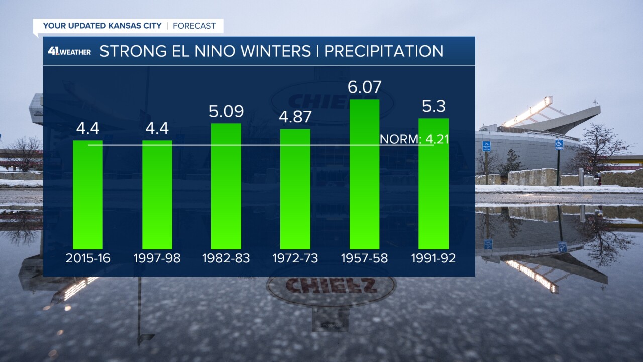
Strong El Niño's
- 2015-2016: ONI 2.5
- 1997-1998: ONI 2.2
- 1982-1983: ONI 2.2
- 1972-1973: ONI 1.8
- 1957-1958: ONI 1.8
- 1991-1992: ONI 1.7
Moderate El Niño's
- 2009-2010: ONI 1.5
- 1965-1966: ONI 1.4
- 1986-1987: ONI 1.2
- 1968-1969: ONI 1.1
- 1963-1964: ONI 1.1
- 1994-1995: ONI 1.0
Weak El Niño's
- 2002-2003: ONI 0.9
- 1987-1988: ONI 0.8
- 1953-1954: ONI 0.8
- 2018-2019: ONI 0.7
- 2006-2007: ONI 0.7
- 1977-1978: ONI 0.7
- 1976-1977: ONI 0.7
- 2004-2005: ONI 0.6
- 1979-1980: ONI 0.6
- 1958-1959: ONI 0.6
- 2014-2015: ONI 0.5
- 1969-1970: ONI 0.5
- 1951-1952: ONI 0.5
As I write this in early November, the world's oceans are all HOT. The Pacific, Atlantic, Indian, Arctic & Southern Oceans have sat near record breaking temperatures since the spring. During the heart of summer, the whole ocean was over 1°C above the 20th-century average. That is significant because it was the first time that's ever happened in the 174 years of record keeping. The current temperature anomaly along the area monitored for ENSO is 4-6° above normal.

The latest ONI is ranging from 1.4-2.2, putting us on track for a strong El Niño to hold this winter. So what does that mean?
Let's start simple: El Niño in general means a warmer northern tier and a wetter southern tier with a dry pocket through the northern Mississippi Valley.

In Kansas City, we see a clear warm trend but our rain and snow trend can get a little fuzzy. When we look at mean high temp, mean average temp, and mean minimum temperatures during strong El Niño events, the evidence for the warm signal grows. All three categories are warmer than normal with overnight temperatures showing the biggest warming trend.
- Average Maximum Winter Temp - Strong El Niños: 42.5° (+1° above normal)
- Average Mean Winter Temp - Strong El Niños: 34.3° (+2.4° above normal)
- Average Minimum Winter Temp - Strong El Niños: 26.1° (+3.8° above normal)


When it comes to rain and snow, there is where things get interesting. The Climate Prediction Center recently published a map showing where snow is favored during moderate-strong El Niños. If you look closely at Kansas and Missouri you'll see there is a pretty stark blue to brown gradient. Meaning we are right in the cross hairs of rain vs snow. With southern Kansas showing some favor to see above average snowfall and northern Kansas and northern Missouri to favor below average snowfall.

But let's look at rain and snow trends specific to Kansas City during strong El Niños. For rain it's pretty obvious: We trend wetter than normal during strong El Niños. For snow it's not quite as obvious, we do trend near or below average for snowfall but there have been cases of big snows during El Niño years.
- Average Rain - Strong El Niños: 5.02" (+0.81" above normal)
- Average Snow - Strong El Niños: 11.98" (-2.87" below normal)

While snow trends low five out of the six years we've seen strong El Niños, if you look at the entire record it becomes muddy quickly. You can see through all our El Niño winter's snow totals are all over the place. The average snow for all El Niños winters is 13.5". Might be a number to remember ;).

The last storm we saw (the one right before Halloween) was starting to follow an El Niño pattern as it lifted in from the south. If this cycle of southerly storms continue then it could be hard to get cold air to mix in to create snow and our winter could favor more rain and ice. There is always a caveat though: If we get stuck in the comma head of any systems this winter we could see some solid snows. Which can happen and tends to be the set up we watch for during big snow events. We will have to monitor how systems start to cycle. So what are we thinking will happen this winter? Our weather team has been busy working on our winter weather special and all have snow predictions for the upcoming winter. But you'll have to tune in on Nov. 29 to hear what they are!

Keep in mind El Niño is just one piece of the puzzle when it comes to the winter forecast, but it sure is a fun one to talk about!
