

Good morning bloggers,
The Polar Vortex has us under its control.. It may take two more full weeks for us to get out of this Arctic outbreak. I wish I had better news, and if there is a sign of any break in this cold wave, I will let you know. A warm up into the 40s or 50s is likely before the end of this month, but for now we have be prepared for an even stronger surge of Arctic air. The next blast is due in this weekend.
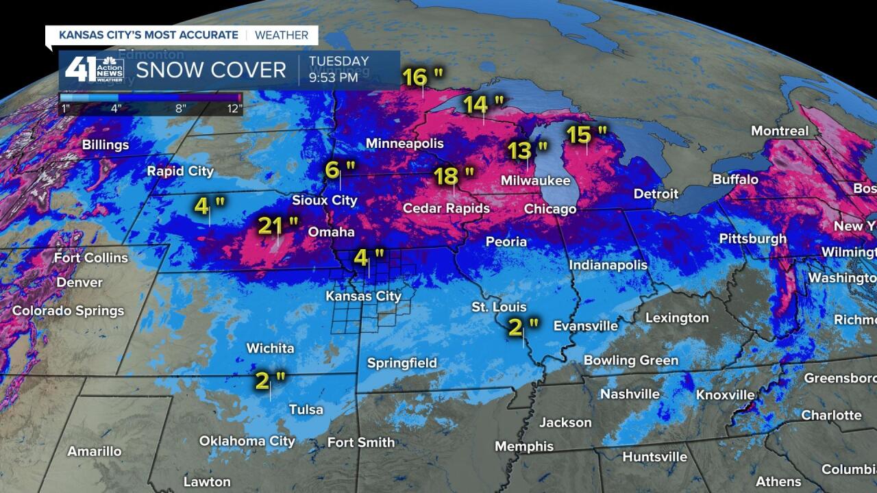
Snow extends from Oklahoma north to the North Pole. When you have a snow pack this deep, it is hard to get the air to modify. Here is the snow cover map as of last night:
We have a chance of a little bit of snow or freezing drizzle today, but we at least don't have an Ice Storm Warning like they have to our southeast:

I am just getting started on the blog....... check back in by 8:30 for the completed blog...
While this storm tracks across the southern United States, we have very weak systems tracking across our area. There is a chance of snow and freezing drizzle today, and as of 7 AM there were very few signs of anything developing early this morning. We are monitoring closely for that thin band of snow that I showed on the 10 PM newscast last night, and there is some evidence of something getting started over Kansas, but I am not convinced yet.
Major Arctic Blast
Another Arctic blast is organizing and it will arrive this weekend into early next week. The high pressure area has a center with very high values. The high is forecast to be 1050 milibars over North Dakota on Valentines Day. This is equivalent to 31.00" (31.00 inches of mercury). This is very high pressure, extremely high pressure. Some light snow shows up on this map on Valentine's Day. If it is cloudy it will not allow us to drop much below zero. The sky may clear Sunday night into early Monday. If it does clear then the temperatures may crash to record lows.

Temperature Forecast Valid Noon Sunday:

This map shows below zero air from Kansas City northward. There is a storm forecast to miss us to the south Sunday night and Monday. If it is closer to KC, then it will be cloudy, and it will not allow for that way below zero drop in temperatures. As of right now, Monday now looks like the coldest morning with 10 below or lower possible.
So, for today, we are monitoring closely for that thin band of snow. It is very close to snowing right now. Something may pulse up on radar, and suddenly it could be snowing outside for a couple of hours later today. We have a 50% chance of that happening. There are other storm systems tracking all around KC in the next five days. One of these may target our area, and at this moment, the chances are there, but I don't see a good chance. This is why on our 7-day forecast we had most of our chances at 30%.
The Kansas City Weather Time-Line:
- Today: Cloudy with a 50% chance of any measurable snow. There will be a few snow flurries of some mixture of freezing drizzle. The wind will blow from the north at 5-15 mph causing cold wind chills near 0 degrees. High: 15°
- Tonight: Cloudy with a 20% chance of light snow. Low: 10°
- Thursday: Cloudy with a 30% chance of light snow. High: 13°
Thank you for spending a few minutes of your day reading the Action Weather Blog. Have a great Wednesday.
Gary
