

Good morning bloggers,
There is a major shift in the weather pattern in progress as we move through Super Bowl week. This change will likely affect the weather in Tampa Bay with a rare strong cold front possibly timed for Super Bowl Sunday. Let's take a look at what is causing this shift/change in the pattern, and what it means as we forecast the results.
ARCTIC BLAST WATCH!
Arctic air has been stuck over northern Canada for weeks now, and conditions are becoming favorable for it to be released southward into the United States with the first blast likely later this week into Super Bowl weekend.

We have been issuing these watches far in advance of Arctic blasts for a couple of decades now. It isn't an official type of watch from the National Weather Service, and I think it should be one. The problem for them is that it is a longer range type of watch. Using the LRC, we can identify these far in advance. In our winter forecast we discussed how the Arctic Oscillation and North Atlantic Oscillation are influences on the pattern, and there would likely be one or two long stretches of true winter weather if we get any blocking over northern Alaska, Canada, or Greenland. And, one of these blocks started developing around ten days ago.
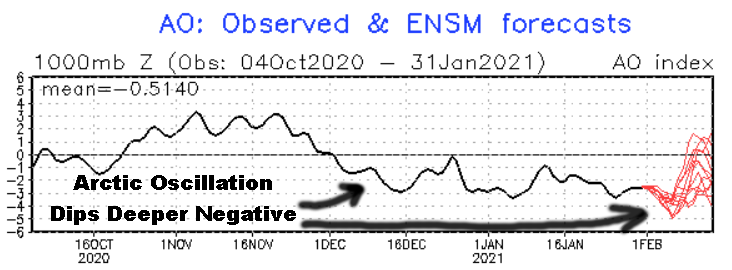
The AO is dipping deeper negative. This has finally resulted in a block forming over northern Canada. We can see this block that formed around one week ago.

The Upper High I am pointing to way up top right on this map, shows the block that fully formed over a week ago. It was actually moderate in strength, and the Arctic air has not budged yet, but it is about to. That upper high is now falling apart. It just influenced the pattern enough to bring us the recent rain storm that turned into a major snowstorm in Chicago, and currently in New York City, and many other big cities over the east coast. There are signs of some more blocking developing as well, and the pattern is just now becoming favorable for a major Arctic surge southward.
Super Bowl Sunday Temperature Outlook From The GFS Model:

This blast of cold is something that we have to pay close attention too. Look how cold that air mass is forecast to be by Super Bowl Sunday, and also notice the colder air is blasting as far south as Florida, reaching Tampa Bay on Sunday. This may drop the temperatures into the 40s or 50s with a north wind for the game. Any chance of rain appears to be blowing through there way before the game, and we will be monitoring that forecast as well.
We have not even come close to having a blast of Arctic air this entire season. The coldest temperature happened around 46 days before this weekend, and the storm on the east coast today is 46 days after the last one foot snowstorm that hit NYC. Yes, they have had multiple huge snow events, and it is right on the LRC Cycle. So, we had a cold outbreak in our forecast for this next ten days, but we weren't certain it would be a major Arctic Blast. It appears that it will, and we have not been used to this at all. The past 30 days have been very warm over the northern plains and most of the United States. The past 90 days have been about the same as well, almost identical to this past 30 days:
The Last 30 Days:

A warm winter so far is about to change
It has been a mild winter and this trend will continue through Thursday morning, and then the change begins. It will likely make a run at 60 degrees here in Kansas City on Wednesday.

Before any Arctic air arrives, we get to enjoy this warm up around Tuesday into Wednesday. Today, in Kansas City it will likely be socked in with a low cloud deck. These will likely break up after some fog later tonight into early Tuesday.
What does this all mean for Kansas City?
- A warm up in the first half of this week
- The Arctic Blast will likely come in two to four surges
- There will likely be a few small chances for some snow, and likely one good chance of a major winter storm. There was a strong and wet rain event at the end of the year, and the part of the pattern that created that storm will cycle through in these next 15 days. That is the best chance of a major winter storm near KC, but there are other smaller candidates
- This blocking will fade and we will likely return to the warmer winter at the end of February and March, but a long cold spell is likely first
Kansas City Weather Time-Line:
- Today: Cloudy & cold with light winds. High: 33°
- Tonight: Cloudy with some dense fog possible. Low: 28°
- Tuesday-Wednesday: Becoming sunny and much warmer. Near 50° Tuesday and near 60° Wednesday
- Thursday: The first cold front arrives with colder air moving in. The true Arctic Blast may be delayed a couple more days
- Super Bowl Sunday: The Arctic Blast likely arrives and the cold front moves through Tampa Bay as well. After 70s for days, their temperatures will be dropping. We will be monitoring this forecast as well
We hope everyone is doing well. This is a major change, and we issued the Arctic Blast Watch so you can think about preparing now. We will go in-depth on 41 Action News today and tonight, and all week as the Super Bowl approaches. Go Chiefs!!!!!
Thank you for spending a few minutes of your day reading the Action Weather Blog. Have a great start to your week.
Gary
