

Good morning bloggers,
The weather is looking great for the Chiefs/Raiders game at GEHA Field at Arrowhead Stadium Sunday. Between now and then we have some ups and downs as this strange December continues to unfold. We are seeing some big changes by Christmas week. Let's discuss!
A storm system is approaching, and it may actually break the dry spell. Well, just barely, and maybe. Kansas City has reached 25 days in a row with no measurable rain or snow:

There is a storm approaching, and the streak may end Friday with a thin band of rain showers zipping by. The chance is still just 20%, but it may briefly rain between 10 AM and 3 PM Friday ahead of a cold front. We are going into the warm sector of this storm:

The warm front is forecast to be south of KC Friday morning, but it appears it will lift north as the surface low (the red L) tracks northwest of KC by afternoon:

LRC Long Range Weather Prediction: This part of the pattern will cycle back through around the first ten days of April, and again in the first few days of June. We will get more specific on the timing when we narrow in on this year's LRC cycle length. A major severe weather outbreak is possible from this part of the pattern. This is related to a five day stretch of severe weather that happened in October from October 9-13th!
Look at this map closely. The surface low is forecast to be moving into eastern Kansas near Salina. This is at 2 PM Friday. If this was April, then this would be a significant severe weather risk for our area. Well, guess what, this part of the pattern will likely be cycling back through during the first half of April, according to the LRC. But, for now, we don't have to worry about severe weather. We are just trying to get it to rain.
This part of the pattern is leaving KC dry, but look at the risk of severe weather on Friday. In April and June, and possibly in the next cycle in February, this part of the pattern will produce again. The spring versions may be outbreaks!

By Friday Night In The Big Town some snow may sneak into northwestern Missouri with a dusting not out of the question. Take a look at this next forecast map valid at 7 PM tomorrow:
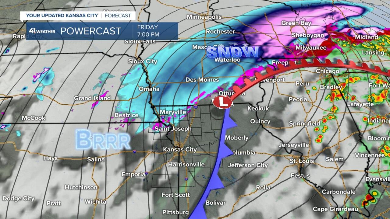
Look at how close that snow will come to us. Omaha and Des Moines may have their first inch of snow, with the heaviest snow north of those two cities. If they had a snowflake contest, then getting that first inch of snow in Omaha and Des Moines will be close. This storm is being produced by a part of the cycling weather pattern that will return around the first week of February. The next time through, that snow may very well be much farther south.
So, what about that change by Christmas week? As we learn more about this years LRC, the cycling pattern, we have narrowed in on the part of the pattern that will arrive Christmas week, and there are three potential storm systems that will affect our area between Christmas week and New Year's week. This is when our next chance of our first inch of snow will arrive. A few of the models are starting to show this chance of some snow. We will look deeper into the Christmas week forecast in the next few days.
The past 30-days have been dry, not just here in KC, but it has been fairly non-eventful nationwide. Only small swath from Washingtion to North Dakota east into northern Minnesota has had above average precipitation:

So, for now, this dry spell is also part of this year's pattern. I did not see this coming, and now we are up to day 25 without any rain or snow, and we are not alone. Denver, CO is still waiting for their first snow, smashing their record for the latest snow ever recorded which was in late November. WOW!
Thank you for spending a few minutes of your day reading the weather blog and sharing in this weather experience. Have a great Thursday,
Gary
