


KANSAS CITY, Mo. — Good morning bloggers,
It is windy in Las Vegas today as energy at around 10,000 to 30,000 feet over the West Coast dives southeast and helps develop a powerful storm system that will affect the Kansas City area in the next three days.

The NFL draft is in Las Vegas and they have some strong winds this morning as the storm begins forming. The wind may affect this evening's NFL draft and then it will calm down significantly on Friday. The draft is outside at the Bellagio Hotel in an area that does have higher impacts from the wind. It will be near 85 degrees in Las Vegas today.
So, the draft may very well be affected by 30-mile-per-hour winds or stronger. It is a factor as this storm dives over the western U.S. and then makes a move towards our region.
As this energy moves out into the Plains, a powerful storm will form. By Friday the weather conditions will improve in Las Vegas, and our attention will be focused on the storm system developing over the Plains. This energy will begin carving out a strong storm system:

Kansas City will have a risk of severe weather Friday night as this energy continues to carve out this storm shown below:

By Saturday, a low closes off and is forecast to be spinning over Iowa and Nebraska. The risk of severe weather is the highest west of Kansas City. Here are the risks:


There is a level 3 out of 5 risk west of Kansas City Friday night. The biggest risks will be damaging winds and large hail. The hail outlook shows a 30% hatched area for very large hail. This means there is a 30% chance of very large hail within 25 miles of each spot. This is also west of Kansas City.
There is still some question as to how organized the thunderstorms will be, and when they will form. We have another one of those caps that may hold until sunset on Friday evening. Take a look at this forecast map valid at 7 p.m. Friday:
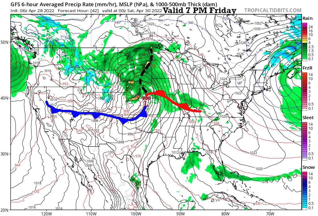
A surface low is forecast to be over Northern Kansas. This model is not forming thunderstorms near and ahead of this front until after 7 p.m., or around sunset. If the thunderstorms form earlier than 7 p.m., then Kansas City will have potential stronger risks from the thunderstorms. Most models start forming thunderstorms after sunset, but I do not have high confidence in that solution at this time.
Now, look at this HRRR-model forecast valid at the same time:

Notice the surface low that is located near the Kansas-Nebraska border, similar to what the GFS (American) model has at the same time in the other forecast map. The HRRR usually does well at forecasting developing thunderstorms. You don't even have to squint, as this model is completely dry at 7 p.m. over all of Kansas and Missouri tomorrow evening. The "cap" is preventing thunderstorms from forming as it did a couple of weeks ago. Thunderstorms will likely form after 7 p.m. out there. The longer it takes to form, the less likely Kansas City will have any severe weather. The risk and threats will cross our area Friday night, so we will be monitoring this closely.
- Today's Forecast: A few showers and thunderstorms are possible with cloudy skies and temperatures in the 60s. The south wind will be increasing at 10 to 25 miles per hour.
- Tonight: Cloudy with a chance of showers and thunderstorms. They are not expected to be severe.
- Friday: A chance of morning thunderstorms. Then, most of the day will be dry through sunset. Thunderstorms will likely form near or after sunset over Central Kansas and move our way. A severe weather risk increases between 8 p.m. and midnight. High: 73 degrees
- Saturday: Partly cloudy and cooler with northwest to west winds of 10 to 25 mph. High: 63 degrees
Thank you for sharing this weather experience and spending a few minutes reading the weather blog. Have a great Thursday!
Gary
