


KANSAS CITY, Mo. — Good Tuesday bloggers -
We are in an active weather pattern that will last around seven to 10 days. We are tracking three storm systems. The first will affect us tonight through Thursday. The second may affect some outdoor activities this weekend. The third is timed for the middle to end of next week. Each one will have a rain-snow line within 100 miles of Kansas City. Right now, it looks like we are on the rain side of each one, but it is not set yet. Below we will focus on the first one.
TODAY:
Here is the set up at 2 p.m. 70s and 80s are found in the southern USA with Arctic air in the northern USA. We are in the middle with highs in the 40s. The front that came through Monday has stalled in the southern Plains. The stalled front allows systems tracking out of the southwest USA to pick up Gulf of Mexico moisture and send that moisture over the large cold air mass. The is the recipe for clouds and widespread precipitation. This is going to to be the set up tonight through Thursday.

This is Weather Track radar at 2:05 p.m. The first round of rain and a few thunderstorms was on out doorstep. It will lead to a wet evening rush hour. The next four rush hours will likely have wet roads as well.

As we look at the big picture you can see we are in rain by 7 p.m. today with lighter rain all the way southwest to Mexico. This indicates all of the small systems heading this way.

The main storm heads into the Plains Thursday. This is when we could see a bigger area of heavy rain. If you are a snow lover, it is frustrating as the heavy snow will be a state away across Iowa and Nebraska.

TODAY 7 p.m.:
We are in a widespread rain with temperatures in the 40s. This maps shows temperatures about 5 degrees too warm.

WEDNESDAY:
This 5 p.m. map is the story for the whole day. It will be drizzling and misting most of the day with temperatures 40°-45°.

THURSDAY:
We will likely see a period of heavier rain during the morning. It will be preceded by and followed by drizzle. The drizzle will end Thursday evening. Temperatures will be 35°-40°. You can see the southern edge of the snow on the Iowa-Missouri border.
Friday will be windy and cold with highs around 40. We have concerns for the parades on Saturday as a cold rain is looking more possible. It looked like a Sunday rain yesterday. It still could change.

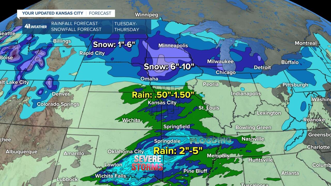
RAINFALL FORECAST TONIGHT-THURSDAY:
Our area will be mostly in the .50"-1" range. There will be some locations that are in the 1"-2" range.

While we are seeing .50"-1" rain, it will be falling as snow across Nebraska and Iowa. Iowa may see 6"-10" of snow with a dusting to 1" right near the Iowa-Missouri border.
In summary after the heavier rain ends around 10 p.m. we will be in for about 30 straight hours of drizzle and mist with temperatures in the low 40s.
The wind tonight through Thursday will be mostly east at 10-20 mph.

Have a great week and stay healthy.
