


Good morning bloggers,
There is a lot to discuss this morning, and if you have any questions come by the Nebraska Furniture Mart Saturday. Our weather team will be answering questions, and we would love to meet you. Sunny & Rainbow The Weather Dogs will be opening up our presentation around 11:30 AM. So try to get there before 11:30 AM Saturday.
Topping our weather news is an approaching storm. We had some frost and a light freeze in the region today, and it will be mostly sunny ahead of the approaching storm. Take a look at the forecast map valid at 4 AM tomorrow morning:

A lead wave of rain will move through before 4 AM and this is why our rain gauge shows 0.05" already. That area of rain and snow out west will be marching our way at 4 AM. Look at this next forecast valid at 7 AM Friday:

A late winter storm is going to produce heavy snow over parts of Colorado, Wyoming, Nebraska, and Kansas. As this area moves towards KC it will be a cold rain, and it is close to being snow. By 1 PM Friday the rain is still inching east, while the snow is reaching central Kansas. Even though this snow is missing KC, could there be another chance? More on that in just a second.

This storm will likely produce between 0.50" and 1.50" of rain in our area. Lower amounts are likely northeast and east of KC with higher amounts near and west of the state line.

This model has 0.75" in KC and the rain isn't over yet at 8 PM. Expect a very wet Friday, so plan for rain and cold all day tomorrow. Look at what is upstream:
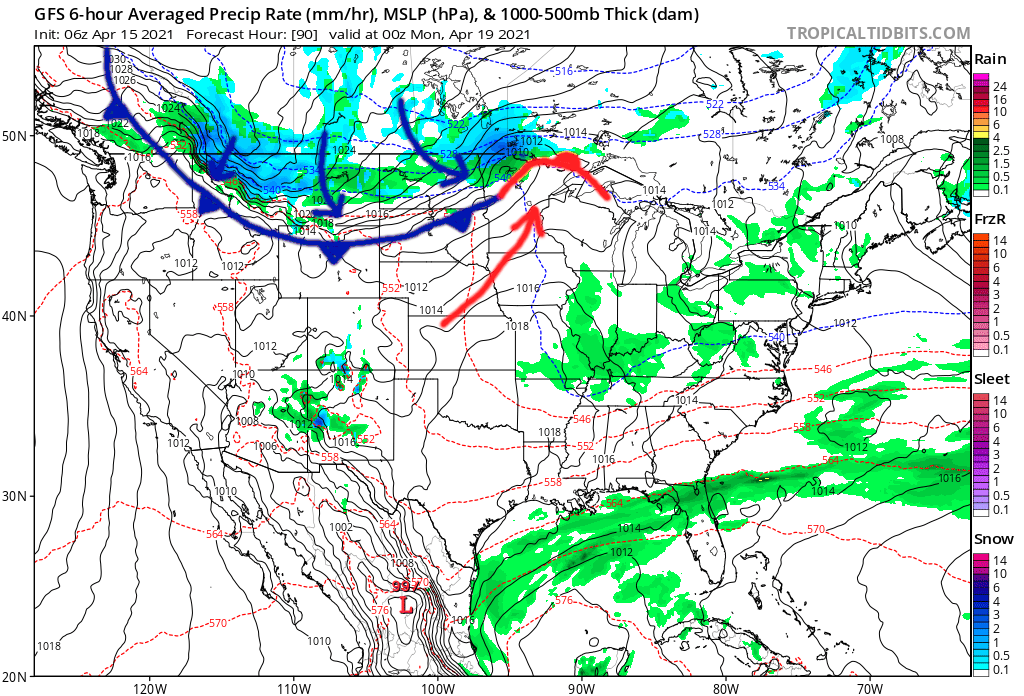
An even stronger cold front is forecast to develop by late this weekend. This means we will get a warm up to near 60 degrees Sunday as this front approaches. And, then the American Model (GFS) shows this on Tuesday morning:

The American Model has been the superior forecast model in the past couple of weeks. But, this does not mean it is handling this chance of snow well. It certainly has our attention, however. The other models weaken that area of rain and snow and have it falling apart before getting to KC. If this GFS model is accurate at all, we could see some accumulation of snow early Tuesday morning on grassy surfaces. WHAT? Yes, it is a possibility. It would be our 8th latest snow of all times if it does accumulate at all.
Would you like some warmer news? Take a look at this forecast for April 28th:

Yes! This has 70s to 90s in the plains before the end of the month. So, get your jacket out, and keep it handy between now and then & keep this warmer air in your mind as it is likely going to happen before the end of this month.
Kansas City Weather Time-Line:
- Today: Mostly sunny with increasing afternoon clouds. High: 58°
- Tonight: Rain spreading in before sunrise. Low: 44°
- Friday: A 100% chance of rain, possibly heavy at times. Rainfall amounts of 0.50" to 1.50" likely. Most areas will be between 0.50" and 1.00". The rain will likely last most of the day into Friday Night In The Big Town!
- Saturday: Cloudy with lingering rain showers. High: 54°
- Sunday: Mostly sunny with light southwest winds. High: 60°
Thank you for spending a few minutes of your day reading the Action Weather Blog (Gabbing With Gary Blog). Have a great day and we hope to meet you on Saturday.
Gary
