

Good Tuesday bloggers,
Even though many locations need more rain, we all got to enjoy a break from the June humidity. The official low this morning at KC was 53°. The record low for KC is 50° set in 1902. We came close. It dropped to 47° at Kirksville, MO!

We know the comfortable air can't last forever in this area during June. 2021 will be no exception as south winds bring the steam back Wednesday. This will set the region up for a few rounds of very heavy thunderstorms. This occurred last weekend about 100 miles east of KC. Is it western Missouri and eastern Kansas turn to see heavy rain? We do need it.
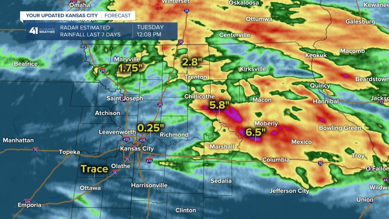
Here is a list of June rainfall totals through today. The wettest is Chillicothe, MO at 2.75", and this is still almost 50% of average.

Lets go through the forecast.
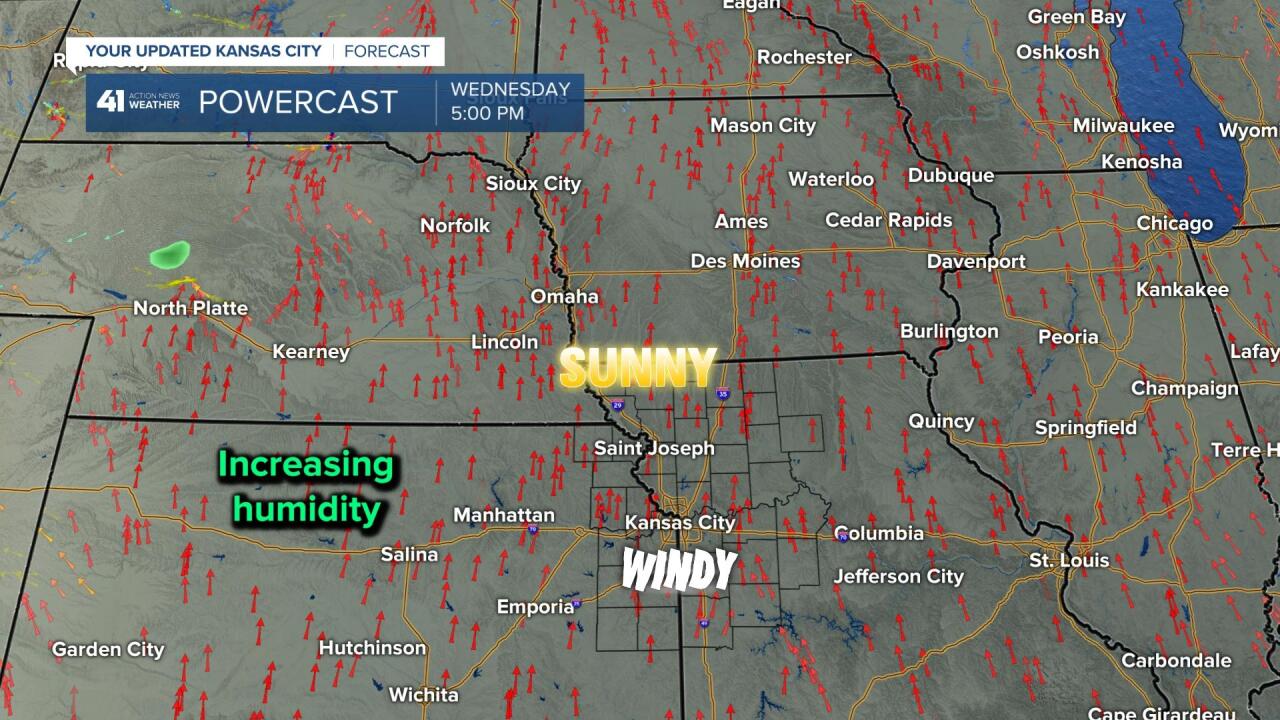
WEDNESDAY AFTERNOON:
After lows in the 60s which is 10 degrees warmer than this morning, but still comfortable, highs will reach 85°-90°. The wind will become S-SW 15-25 mph bringing in higher humidity.
The pattern Thursday and Friday will be a somewhat typical one for the end of Spring and Summer. We will be in northwest to west flow which means the upper level flow is moving from northwest/west to southeast/east. This is a mostly dry pattern during the fall and winter. But, during the end of spring and summer when there is more moisture available it can become a rather wet pattern. Zones of excessive rainfall can set up.
If it seems like we get most thunderstorms late at night or early in the morning this time of year, you are correct. Thunderstorms that form in the western Plains during the afternoon and evening can grow into complexes of thunderstorms overnight. When we are in northwest/west flow they can ride in here between midnight and noon. This happens a lot during the period June-August.
That being said, take a look at the green dot north of North Platte, NE. This is the beginning of a thunderstorm complex.
WEDNESDAY 5 PM-MIDNIGHT:
The little green dot has become a bigger area of yellow , orange and red across southern Nebraska and far northern Kansas. This is now a complex of thunderstorms tracking southeast in northwest flow.
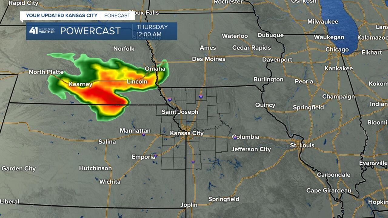
THURSDAY MIDNIGHT-5 AM:
This data has the thunderstorms tracking south down I-29. This would be good news for these dry areas. Now, sometimes you can get too much rain and damaging winds. We will be watching for this. Also, the track is not set yet. It could go 50-100 miles farther east or west.

THURSDAY EVENING/NIGHT:
New thunderstorms will be forming along I-80, south into Missouri. So, if you miss the first round there is another chance.

THURSDAY NIGHT-FRIDAY MORNING:
The evening thunderstorms form into a complex and drop south, just east of the state line. This round could also track 50-100 miles farther east or west.
If this round is a miss, there will be a chance of scattered thunderstorms Friday afternoon and evening along a cold front. This looks similar to Sunday which means hit and miss. So, hopefully your yard or farm gets the rain it needs before Friday afternoon and not too much.

RAINFALL FORECAST NEXT 5 DAYS:
This computer model has much of northwest and west central Missouri receiving 2" to 6" of rain. This is needed, but could be a bit excessive. Also, notice Ottawa, KS receives 0.05" of rain. There is a 5" rainfall difference in 66 miles. So, you can see a shift of those complexes by 50-100 miles east or west will make a huge difference in how much rain your yard or farm receives.

RAINFALL TOTALS THE LAST 7 DAYS:
The heaviest occurred from Iowa to central and east central Missouri. It would be nice if we can get these next rounds to track farther west. We lean in the farther west solution, but it is not set yet.
Have a great rest of your week and stay healthy.
