


Good morning bloggers,
One week ago this morning it dropped to -22° around Kansas City with wind chills as low as around 35 degrees below zero. This afternoon we will be warming up to 75° in the sun and this is 110° warmer than one week ago. Also in today's blog we will provide a first look into hurricane season emphasizing the LRC technology from Weather20/20. https://www.weather2020.com/ Hurricane season for the 2021 season actually begins in the fall of 2020 when the new LRC sets up.
The LRC:
- A unique weather pattern sets up each fall and becomes established between around the first week of October through November
- Anchor troughs and ridges set up. These show us the regions that will be hit the most by the strongest storm systems (near the anchor troughs), and where storm systems will mostly miss (near the anchor ridges
- The pattern is cycling and regularly, and each fall a cycle length gets established. The river of air within the troposphere between around 10,000 and 30,000 feet is cycling and storm systems are predicted with a high level of accuracy.
- This cycling weather pattern that becomes established in the fall continues through winter, spring, and summer before the new and unique pattern once again sets up the next fall
The LRC is the centerpiece of the big atmospheric puzzle. There is order in what most think is chaos. The LRC describes this order.

There are other influences on the pattern. ENSO (El Niño Southern Oscillation) has been in a La Niña event this winter. La Niña is currently in full force and a strong influence on the cycling pattern. The Arctic Oscillation (discussed in many previous blogs) has also been a big influence on this years pattern. On January 21, we accurately predicted that blocking over northern Canada and Greenland had developed and we then knew that there was a very good chance of an Arctic Blast developing and it would likely head all the way to the Gulf of Mexico. We issued that Arctic Blast Watch & Warning then, and we know what happened just two weeks later. Texas was devastated and snow storms struck many unusual places in the south. This AO influence is now gone and the Arctic Air has retreated north.
Kansas City was was in a very difficult spot to describe the weather, and we have experienced the lowest amount of snow in the entire region:

The foot of snow for the season is the lowest amount of any city from the Texas Panhandle east to Arkansas and north to the USA/Canada border. Des Moines, Omaha, Chicogo, and Lincoln, NE have all had close to 50 inches of snow this season. Some of these spots are so close to KC, and yet KC has not had one major snowstorm all winter. Our prediction of 15.5" that I made last fall is looking good at the moment.
A Look Into The 2021 Hurricane Season:
The pattern is cycling regularly and our predictions of winter storms, tropical storms, and severe weather outbreaks have been quite accurate in and increasingly so in recent years.
Accurate Predictions From Recent Years:
- Major Hurricane Harvey that blasted into Texas a few years ago was predicted 55 days before there was even a cloud, and it was predicted to become a major hurricane three weeks ahead of time
- Tropical Storm Gordon was predicted 8-months before anything developed, and this prediction was made in at the American Meteorological Society's conference in Austin Texas three years ago
- 11 of the 12 named storms that made USA landfall last year were predicted from weeks to months ahead of time on where landfall was most likely and also the time frame of when they would form
Another Very Active Hurricane Season Is In The Forecast
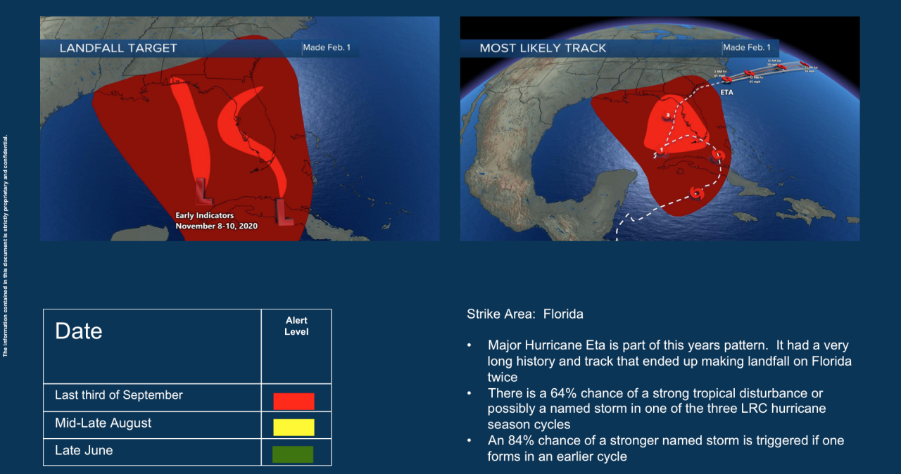
We are forecasting 16-20 named storms this year, including 3 major hurricanes. The main targets are shown here in red:
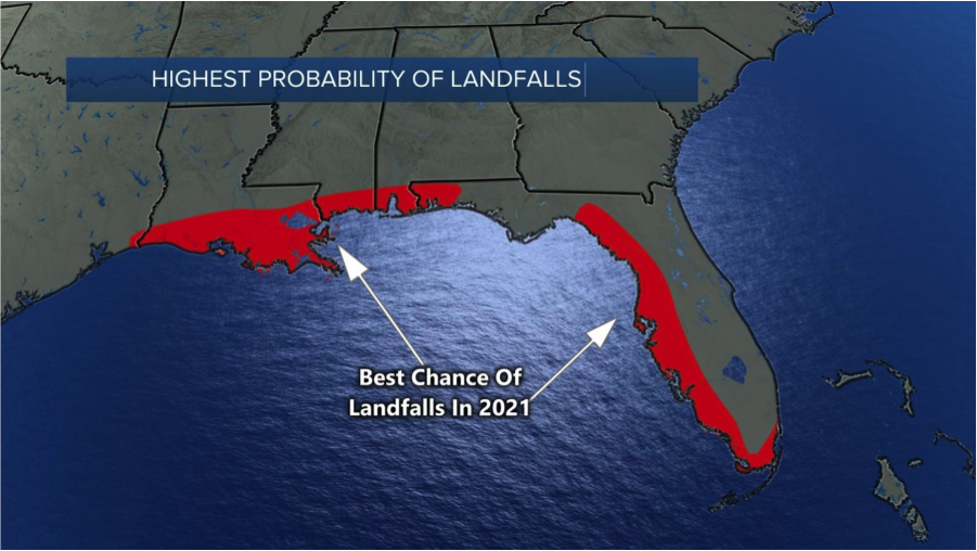
Based on the beginning of this year's pattern, Louisiana and Florida are big targets this year. In last year's prediction, Weather2020 accurately predicted that Florida would be missed in a very active hurricane season. And, Florida had no landfalls until this year's pattern set up last fall. The only landfalling storm was Hurricane Eta that made two Florida landfalls in November. This is one of the reasons why Florida is a landfall target for this summer.
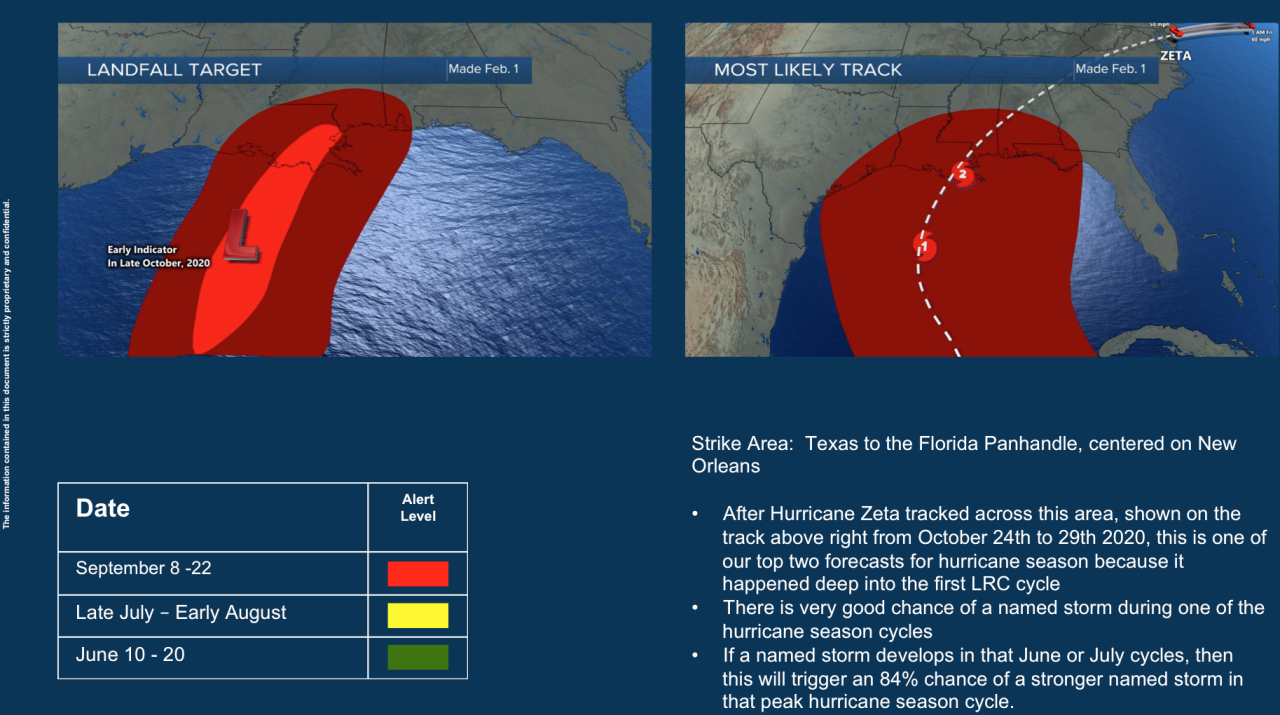
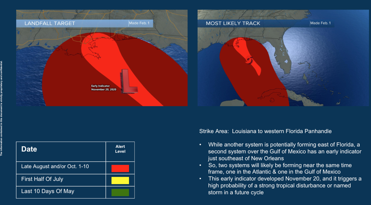
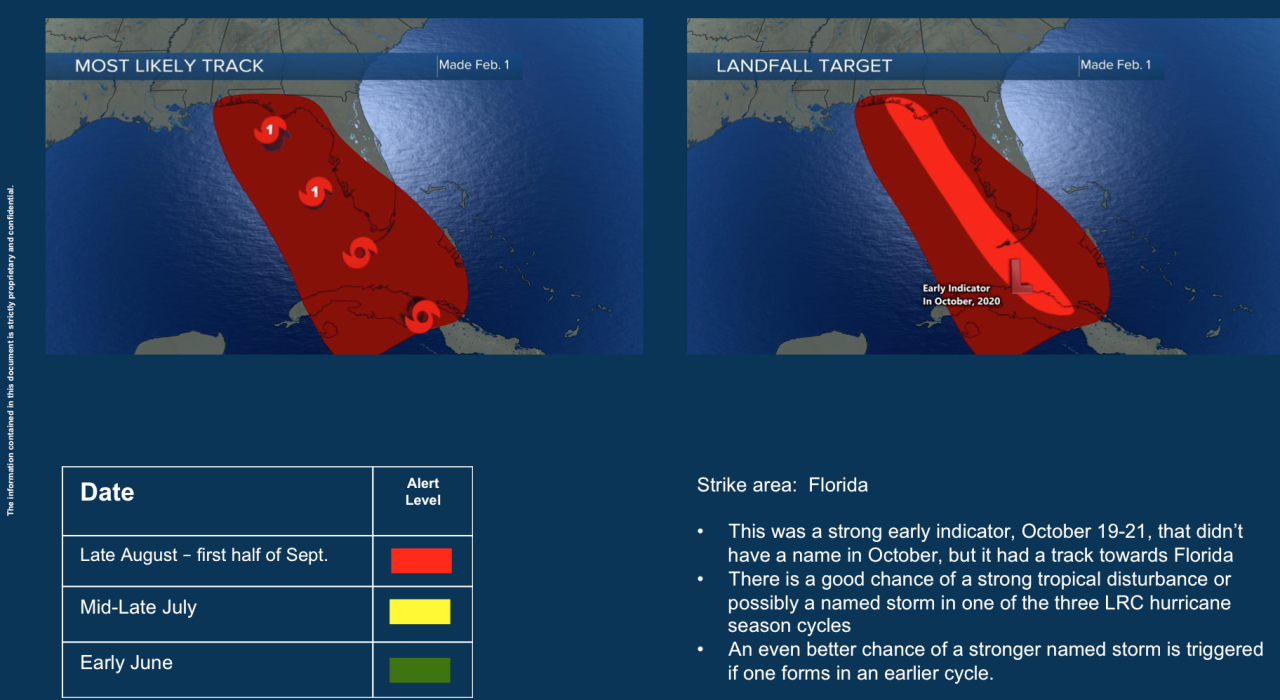
A few of our predictions:

We will be monitoring the cycling pattern, the LRC closely as we move closer into hurricane season. You can track these with us.
Today in Kansas City:

There isn't a cloud in sight today. A few high clouds will be increasing later this afternoon, but before then there is a good chance of it reaching 70 degrees. As discussed yesterday, the air temperature we report to you each day comes from thermometers that are in shaded and ventilated weather shelters five feet above the ground. The actual air temperature in the sun will be around 10 degrees warmer, so it will feel like close to 80 degrees in the sun this afternoon, or 110 to 115 degrees warmer than it felt just one week ago when the wind chill was 35 degrees below zero.
We hope you get a chance to stop and smell the roses today, and get outside for a walk. I will be taking Sunny & Rainbow for a walk around noon today as by then it will be in the 60s and warming up. Thank you for spending a few minutes of your day reading the Gabbing With Gary blog. Have a great day.
Gary
