


Good morning,
While the weather is very calm right now, lets look at a set up for next week and discuss why or why not there will be any severe thunderstorms in our area. A severe thunderstorm is really a strong cumulonimbus cloud. Let's take a look at the "Supercell" thunderstorm today:
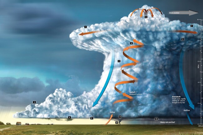
This picture shows the structure of what we call a "Supercell Thunderstorm". Airplanes should never fly through one of these, and pilots know to fly around them. The updraft, which is shown as the rotating column in this picture, will have wind speeds blowing straight up at possibly 100 mph in the stronger severe thunderstorms. If an airplane were to encounter that updraft it could result in catastrophic circumstances. So, pilots will not even think about flying through one of these thunderstorms. Tornadoes will develop underneath that updraft.
- The updraft is really the center of the strongest part of the thunderstorm and if conditions are right, the pressure will drop and this causes the clouds to form lower underneath that updraft. These clouds may have a rotation to them developing
- When there is rotation in that lowering, we call it a "wall cloud". If there is no rotation then we just call it a lowering
- The anvil that spreads out shows the top of the Troposphere. The updraft is caused by the release of latent heat when the air condenses and the clouds bubble up. The clouds will rise all the way up to the stratosphere, and then the clouds aren't able to keep growing, which is good because we don't want them to be even stronger. When the clouds hit the Stratosphere, where the air warms up and stablizes, the cloud spreads out into the anvil shape.
- There is sometime an overshooting top when the clouds force their way into the lower Stratosphere, but that is short lived
Conditions that are needed for severe thunderstorms to form:
- There needs to be adequate low level moisture. Warm moist air coming up from the Gulf of Mexico is essential and the first ingredient needed for severe thunderstorms to form.
- The right thermodynamic conditions: After you have adequate moisture, there needs to be very cold air aloft and a warm air source to provide the conditions for the updrafts to form. If a disturbance, that we often call an upper level storm or an upper level disturbance is approaching, it is associated with a cold pocket of air aloft. When this moves overhead, the warmer air below will have an easier time to rise and produce clouds and precipitation
- Wind shear: The change in wind speed and direction with height. If there is a south or southeast wind at the surface, and then it turns to the west aloft, and that disturbance is approaching, then the conditions for the updrafts to rotate more violently develop
- A front at the surface, or a wind shift boundary. If the winds are converging together, i.e. a northwest wind meets a south wind along a cold front, then the air is forced to rise. The air can't go down at the ground, it has to go up. This causes clouds to grow and thunderstorms develop
Let's look at the set-up for next week:
There are two possible severe weather set ups showing up for next week. In Kansas City, right now it appears both severe weather risks will be south and southeast of our region. We may be closer to the snow from the second system than the severe weather. Kansas City is often in one of those spots that just a little difference, and suddenly we have a severe weather risk, and a bit different the other way, we suddenly are in the snow risk. We are often in the middle.

Next Wednesday there is a fast moving storm that will zip by Tuesday and Wednesday. The ingredients for severe weather are likely going to push well to the south and east of our area. Look at what happens just a couple days later:

By one week from Friday, and the LRC strongly supports a storm system within ten days that will have more impacts on Kansas City, a storm is forecast to develop. A major snowstorm is likely in the cold sector of the storm, and a potential severe weather outbreak is possible in the warm sector. Kansas City, as usual, is in the middle between the two extremes. We will be monitoring this closely in the next week. The warm and moist air will potentially be moving into Oklahoma and southern Missouri. If this storm is a bit farther northwest, then we could suddenly have a severe weather risk. If it is just a bit farther south and east, then the winter part of the storm would suddenly be overhead.
For today, and the rest of this week, we get to enjoy outstanding weather. Expect a high between 65 and 70 degrees today and tomorrow. And, today it will come with light winds.
Thank you for spending a few minutes of your day reading the Action Weather Blog. Have a great Wednesday.
Gary
