


KANSAS CITY, Mo. — Good morning bloggers,
Yesterday we discussed the "cap" on KSHB 41 News. Take a look at this video:
The cap is a layer of warm air aloft that prevents thunderstorms from forming. If the cap breaks, then thunderstorms become intense as they explode through the cap and form into severe thunderstorms. If the cap breaks today, then we may have our first tornado watch in 1,050 days. It has been 1,049 days since Johnson County and Wyandotte County have been under a tornado watch. Other parts of the Kansas City area have been in only one in the past three years. This streak will continue if the cap doesn't break. Here is what it does to the thunderstorm chances.
I have looked at all of the models this morning and not one of them breaks the cap. This doesn't mean it won't break, but it will take one of three things to happen:
- If it heats up to 92 degrees or warmer, then the cap would likely break.
- When the cold front catches up with the dryline, the cap will likely break, and this would happen around 10 p.m. tonight.
- If an upper-level disturbance is strong enough, colder air aloft would weaken and wipe away the cap. This is what happens Wednesday to our east.

This map above shows it dry everywhere from Iowa south to the Oklahoma border at 7 p.m. If you look closely, there is a thunderstorm forming northeast of the surface low. This will be the target area for most of the storm chasers today. The cap is holding strong west of Kansas City.
By 11 p.m., below, you can see the thunderstorms forming north of the cold front that has caught up with the dryline:

This is really a rare setup where the cap may not break. Usually, the cap breaks, but it may protect us today. Look at this next map, below, showing a closer picture of the forecast at 11 p.m. tonight:

Look at where the cold front is, and look at where the thunderstorms are developing. There is quite a distance from where the front is located and where the thunderstorms are lining up. The thunderstorms are lining up in the cooler air because of the cap. If these thunderstorms stay off of the front, then the risk of severe weather is lower and the chance they even make it to Kansas City is low.
Could thunderstorms form near the front? They may, and this is what we will be monitoring closely. If they form closer to the front, then we have an increased risk of severe thunderstorms tonight. We will be monitoring this very closely.
By 3 a.m., as you can see below, the thunderstorms have fallen apart on this HRRR model, and most other models as well. If this is accurate, then our threat of severe weather will never materialize in Kansas City. I am leaning in this direction, and we are also not going to take my eye off of this line as it moves through.

By Wednesday, the conditions do all come together for a major severe weather outbreak. The thunderstorms finally form on the front because the cap erodes away and no longer protects the atmosphere from forming along the front. This could be very bad news for an area that has already been hit this year. Remember when the Amazon Plant near St. Louis got hit by a tornado and Mayfield, Kentucky, was devastated by a long-track tornado that killed 90 people that day — 56 in Mayfield? They are the target again.

I warned anyone interested four months ago. I titled the blog back then, "Horrific Tornado Outbreak Is A Warning For What Is To Come." Take a look: Weather 20/20 Blog From 4-Months Ago Warning For This Day
The Storm Prediction Center (SPC) just increased the risk to a level 4 out of 5. This is again incredible as this is the third time out of four LRC cycles that there has been a Moderate Risk, or level 4. Here are the risks:

From the SPC:
"Scattered severe thunderstorms capable of producing very large hail, damaging winds, and tornadoes are expected late this afternoon and tonight across a broad portion of the southern/central Plains into the Mississippi Valley. Some of the tornadoes could be strong."
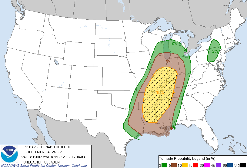
The tornado risk has been increased to a 15% chance of a strong tornado within 25 miles of any spot in that red area:

We will be monitoring this closely, as Northwest Missouri is included in the strong tornado discussion.
By tomorrow, this strong risk shifts to that predicted area from four months ago:
Kansas City weather timeline:
- Today: Cloudy this morning. Increasing humidity and wind. A wind advisory is in effect for wind gusts up to 50 miles per hour. There is no chance of a thunderstorm before sunset. High: 82 degrees
- Tonight: Mostly cloudy with a 30% chance of thunderstorms by around midnight. There is a risk of severe weather with damaging winds the main risk type in Kansas City.
- Wednesday: Turning colder with a few rain showers, possibly mixed with a few snowflakes. Temperatures dropping to near 40 degrees.
Thank you for spending a few minutes of your day reading the weather blog and sharing this weather experience. Have a great day.
Gary
