

Good morning bloggers,
Let's begin with today's weather, and then we will discuss the complex forecast on a series of storm systems that is heading our way.
Today's Great Weather Forecast:
Today is going to be a spectacular day. Expect a high of 58° and a mostly sunny sky. And, the wind will be much lighter than yesterday. Quite simply, it will be fantastic, and I am planning a noon walk with Sunny & Rainbow The Weather Dogs!
The Developing Weather Pattern:

There is a series of storm systems developing. The first one will zip by Saturday night into early Sunday. Last night I showed the battle between the European Model that had KC in a wet storm Sunday, while the American model had us in just a few showers and likely dry for the big game. The American model has been winning most of the time in this year's LRC weather pattern. And, it appears it just won again, but we don't know for certain yet. There is also a block that has formed over northern Canada, and this is like a big boulder in the river of air above us, that is affecting the pattern.
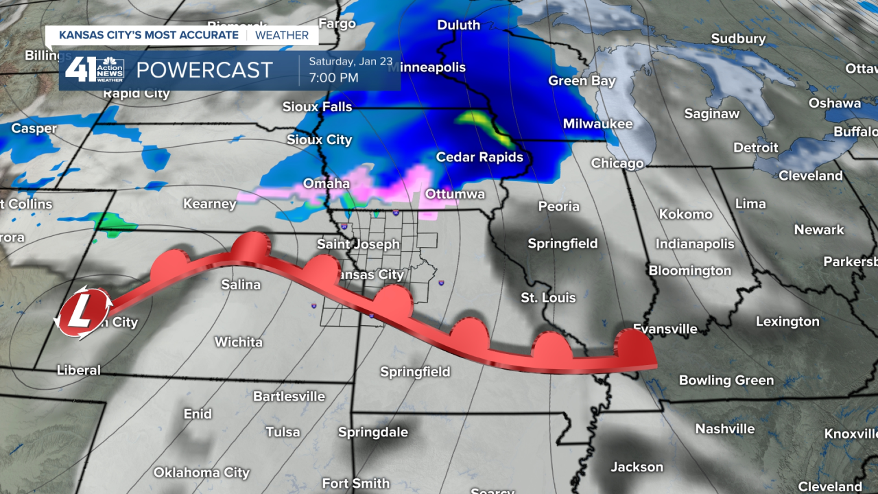
The first storm will be zipping by Saturday night into early Sunday. The timing of this first system is really good news for KC, and maybe even for Green Bay. The Green Bay Packers are hosting the Tampa Bay Buccaneers and snow is likely as you can see above. That first round of snow will end Sunday morning, but there may be lingering snow showers for that game, and it will be cold.
For KC, that red line is a warm front that will be approaching, and also weakening. There may be a mixture of winter precipitation near the Iowa border, and just a slight chance near KC Saturday night as this moves through.

This next forecast map shows a cold front moving through Sunday and the snow tapering off in Green Bay. For KC, this cold front is good news as it should dry us out for a few hours. As a result I am optimistic that the chance of showers is there, but it most likely will be pretty dry, but a bit cold for the game.

Now, remember, we are still monitoring the evolving pattern. Sunday appears to fall in between storm systems, and this would be nice. There is another storm approaching, however, and if the timing continues as it has been trending, then we may have a wet storm arriving on Monday. But, first look at this forecast map for during the 1st quarter of the game. This model doesn't even have any rain or snow close to KC.

Let's Look At Monday's Possible Storm:

Oh my goodness, if this is right? This forecast map shows snow, in the blue shade, and very heavy snow at that, right over Kansas City on Monday afternoon. There are still a lot of questions on the track and strength of this system. That block is affecting the pattern, so let's see how this trends. If this is right, that would add up to our largest snowfall of the season, which wouldn't be that hard to accomplish, as KCI Airport's largest snow has been 2.2".
Thank you for spending a few minutes of your day reading the Action Weather Blog. We will have KC's Most Accurate Forecast on 41 Action News today and tonight. It is going to be a great weather day with a high of 58 degrees. Let's enjoy today.
Gary
