


Happy February Bloggers -
With January officially in the books, I thought it be a good time to take a look back and see how the month stacked up climatologically. It should come as no surprise that January 2023 was warm and wet. But what I think might surprise many of you is just how warm it really was, take a look!

When it comes to our climate, we typically look at mean temperatures (or average) when comparing year to year stats. So it is safe to say this January was the 11th warmest in Kansas City's history. This was the warmest January we've had since 2006. Even after our arctic cold front brought temperatures well below average to close out the month our average high, average low and mean temperatures all ended up 6 or more degrees above normal for the month. That's fairly significant.
When it comes to precipitation - well we were wet, just not white.

While our snow may be a bit behind compared to normal, it's not too far off if you compare it to the last two winters. Think of it like comparing apples to oranges. Our normal doesn't account for our climate set up, ie. La Niña-El Niño, Arctic Oscillation, North Atlantic Oscillation, etc. But the one unique thing this winter has is it's what we call a "Triple La Niña." This is a fairly rare occurrence and the first time this century we've seen a La Niña winter for three consecutive years.
So let's talk apples to apples. How do we stack up to the last two La Niña winters? Well we are on about the same page.

One thing to note about last winter and the year before - majority of our snow came late. Now does that mean we are forecasting late winter and spring snow? Not quite.

La Niña is fading and we are expected to transition to ENSO-neutral during the February-April 2023 season. In a neutral state our trade winds blow east to west across the Pacific Ocean which allows warm moist air and warmer waters to hold over the western Pacific.
What this means for Kansas City is we don't have any extra forcing for cold but we still hold onto that extra forcing for wet. So your saying there's a chance? Well still, not quite. We need the COLD!
While we have had our share of cold snaps our baseline winter temperature has just been warm. One key to watching for cold air is keeping an eye on the Arctic Oscillation (AO). The AO pattern and our upper level set up across North America for the next two weeks favors normal to above normal temperatures across the Central and Eastern US. So our warm trend looks to hold through the middle of February.
But again apples to apples, late season snow is not out of the question, we just aren't seeing the potential in the forecast right now.

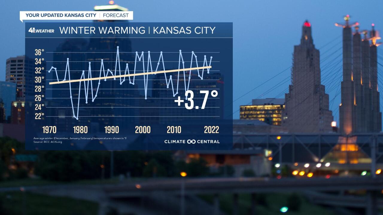
So are warmer winters our new normal? Winter is warming across the country - and it's warming fast. Climate change has begun to alter our seasons and this winter we are beginning to live in that new reality. In a recent study by Climate Central, the average Kansas City winter temperature has increased by by 3.7° since 1970, and this is right on trend with our January warmth.
In their study they found:
- Winter is warming everywhere: Winters have warmed in 97% of 238 U.S. locations since 1970.
- Winter is warming fast: Winter was the fastest warming season for 75% of these locations.
- About 80% of locations now have at least seven more winter days above normal than in 1970.
- In our warming world the coldest days aren’t as cold, and cold snaps are shrinking.
- Warming winters affect public health, water supplies, agriculture, and recreation.
- Warmer temperatures can make winter storms more hazardous, with sleet and freezing rain.
So we have the warm and might hold onto the wet. When will we see white? That is still very much up in the air, but my hope isn't completely lost for more snow come late winter and early spring. Stay tuned!
