


Good morning bloggers,
The chance that we hit 100° at KCI will be increasing in the next 10 days. I am predicting a 60% chance that we do it before the end of this month. I will share two model predictions for around 10-days from now in just a minute.
It was four years ago, on July 12, 2018, that we last hit 100° at KCI Airport. Here are the past five high temperatures on July 12, and also yesterday:

A lot of bloggers and viewers have wondered why we use KCI Airport as our official weather station for Kansas City. It is way out there on the northwest corner of the Kansas City city limits, and not really representative of where most of us live. It is what it is, and there is nothing I can do about it. KCI will continue to be the official weather recording station. Before KCI Airport was built, the records were kept at the downtown airport. So, our records are definitely affected by these two different locations. The hottest temperature in Kansas City history, for example, happened on August 14, 1936, when it reached 113°. Now, there was no KCI Airport then, and this record was recorded at the downtown airport. If it reached 114° at the downtown airport today, that would not go down as the record. So, again, I agree, there are flaws in the record keeping system, and yet the records are now kept at KCI.
Last year, just about everyone stayed below 100° last year. Downtown recorded 99° one day last summer, and as you can see below, it never got above 98° at KCI Airport last year:

The "anticyclone" aloft is what we call "the heatwave creating machine" at this time of the year. We look at the 18,000 foot level, or close to 18,000 feet anyway, to see the LRC well (the cycling weather pattern across the Northern Hemisphere). This is the 500 mb level, or half way through the atmosphere in weight.
Here is the flow at 500 mb valid today:


Some models build the anticyclone out over Kansas in the next 10 days, and others keep it to the south and weaker.
The American Model (GFS Model):

European Model Forecast:
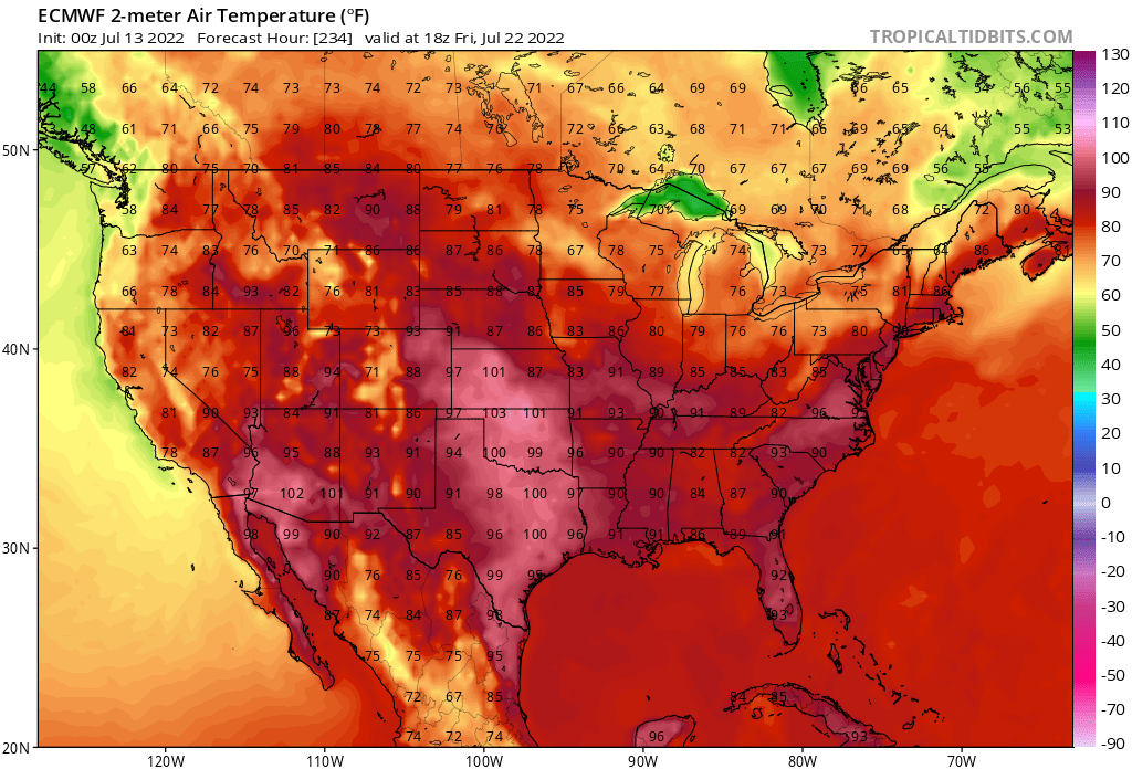
The difference is almost 20 degrees in Kansas City. The European Model has some thunderstorms in our area with clouds and temperatures in the 80s, while the GFS model (American Model) is modeling 102° in KC at 1 p.m. that day. Again, the difference is that the GFS builds that anticyclone over Kansas and the Euro keeps it just to our southwest and it is showing it to be a bit weaker.
Today's weather:
The humidity is still under control today with dew point temperatures in the lower 60s. The humidity will be rising in the next few days with possibly a few thunderstorms near KC by Friday morning.
Forecast: Nearly 100% sunshine with light winds. High: 90°
Thank you for sharing in this weather experience and spending a few minutes of your day reading the weather blog.
Have a great Wednesday,
Gary
