


Good morning bloggers,
There is extensive devastating damage from Hurricane Ian that blasted into the southwest coast of Florida. The hurricane has weakened into Tropical Storm Ian, an incredible rapid weakening of a hurricane overnight.
It is now tracking off the Florida coast and will turn into South Carolina, where it will make a second and much quieter landfall.

Ian will not strengthen much as it moves over the water, due to conditions not being ripe for redevelopment.
This is a good thing. It will still produce a lot of rain along the path before it falls apart Saturday.
Reverse Storm Surge:
We have been discussing how strong the storm surge would be as the hurricane blasted into the coast yesterday. A storm surge is caused by the powerful winds around the hurricane forcing the water to rise.
Yesterday's storm surge may have been as high as 15 feet. Anything 15 feet or lower would get forced underwater, and the power of water is quite impressive, just ask someone who has gotten caught in a wave and the undertow.
This picture shows the Gulf of Mexico water that moved into Naples, Florida:

As the hurricane was tracking inland across Fort Myers, farther north in Tampa, the exact opposite happened. Incredibly, the water in Tampa Bay was pulled out by the east wind circulation north of the center of the hurricane:
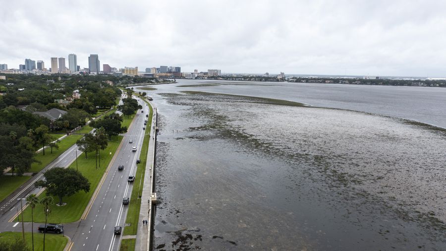
This shows how the water in Tampa Bay was pulled west out of the Bay. There are pictures of boats that were sitting on the Bay floor.
It was really an incredible phenomenon caused by Hurricane Ian.
Well, Ian is going to be history soon. Kansas City doesn't need a hurricane, but it would be nice to get some rain.
Look at this rainfall forecast for the next 15 days:

Look closely, as there is rain in KC by the end of the next 15-days. The New LRC (Lezak's Recurring Cycle) is setting up.
This forecast map ends Oct. 14 and shows around the first week of the new pattern. September is usually wet, but we have had less than 1" of rain this month:
- Rainfall so far this month in Kansas City: 0.84"
- Average rainfall during September: 4.04"
This dry month has helped increase our region go into a worsening drought:
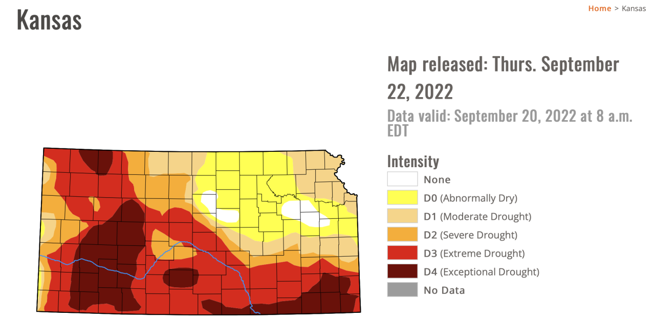
These drought monitors show the drought becoming exceptional over parts of southern and western Kansas. It isn't as bad in Missouri, as you can see below:

At least it is the time of the year when there is one big benefit from the dry weather. We get to experience "Southern California" type of weather where it is just gorgeous every day with no chance of rain.
I am from Los Angeles, and I didn't know any better when I grew up in the San Fernando Valley. I was excited to just see clouds.
There may not be a cloud in our sky today. Expect a near-perfect day with light winds and highs in the lower to middle 70s.
Thank you for sharing this weather experience and spending a few minutes of your day reading the weather blog.
Have a great Thursday.
Gary
