


Good morning bloggers,
Last night was another fascinating weather night.
Look at this spinning disturbance that was moving into Lawrence with 60 mph winds. It was heading right towards the south half of the KC metro area, and it made it there. It had lost its wind by the time it went into Lawrence, but it did not lose the lightning strikes and heavy rain. It slowed down and produced 1 to 2 inches of rain in many spots south of I-70.

By the way, there was no Tornado Watch again. May 28, 2019 will make it three full years without the entire metro area being under a Tornado Watch. Johnson county and Wyandotte county have not been under a Tornado Watch since that day three years ago. It's an incredible record.
There is another storm heading our way. This next storm will once again not produce a Tornado Watch in our area. Here are the risks for Thursday and Friday:

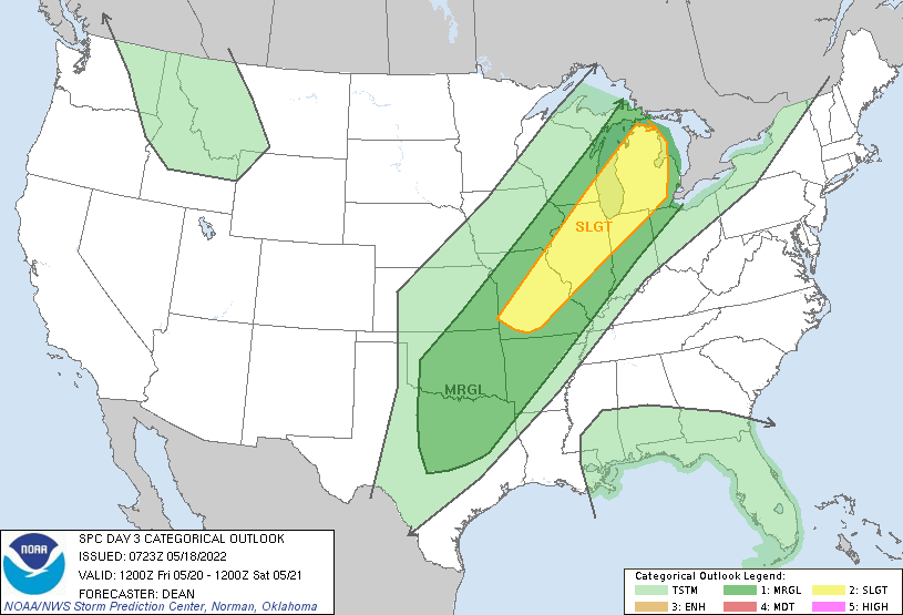
The risks are bouncing around us as well. Even when we have been in a more significant risk, an ingredient or two are just not there to produce major severe weather in our area. Oh, it's been close like the night Andover had that incredibly photogenic moment a couple weeks ago, but by the time the thunderstorms got to our area they had weakened.
A strong cold front:
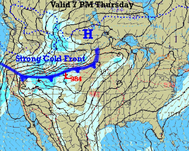
A strong cold front will be approaching our area Thursday night and Friday. As you can see above, a cold front and storm system will be developing over the Rocky Mountains. A strong 984 mb surface low, which is a deep low pressure of 29.05". That is very low pressure. This is going to create the conditions for snow over the Rocky Mountains and it may extend out into northwestern Kansas.

This same pattern, cycling according to the LRC, continues. There is even snow forecast in North Dakota. I was on a podcast and radio station up there and predicted their winter forecast incredibly accurate and farmers over the Dakota's are wondering why others do not use the LRC. I was on that same podcast and radio station months later and we then predicted the blizzards over North Dakota in April, and I even said it would snow in May, and this is the second time this month already.
Denver and west into the mountains will likely experience a winter-like snowstorm in late May this weekend!
Kansas City won't see the snow this time, but we will have this strong cold front move through Friday. There is a chance of rain and a quite cool forecast for the beginning of the weekend. It may be in the 50s on Saturday. Some models have it in the 40s. We will discuss on KSHB-41 today and tonight.
Thank you for sharing in this weather experience and spending a few minutes of your day reading the weather blog.
Have a great Wednesday,
Gary
