


Good morning bloggers,
A High Risk of severe thunderstorms has been placed over the southeastern USA. This storm is affecting Kansas City this morning.
The day began with a large area of rain with a few thunderstorms embedded. We have had occasional lightning, some loud thunder, and some heavy rain. This band of rain will affect the morning rush hour, and then it will move by later this morning. And then, anticipation will build for the possibility of snow tonight. Kansas City has been shown to be the most difficult place to predict weather in the entire United States, and this snow chance tonight showcases one of the reasons why. My next statement will hopefully be taken seriously. There are models that have more than 1 foot of snow in Kansas City by 6 AM Thursday. There is a strong storm moving across the plains and the track of this storm is crucial, and also the temperatures. The European Model has no snow at all because it shows it never dropping below 37 degrees. The other models that have all of the snow are showing 33 to 34 degrees. That three to four degree difference in the models is a one foot difference in snowfall.
Let me show you all of the models, beginning with the NAM model. That light green shade is 12" to 15":
NAM Model:

GFS Model:

RGEM Model:

Canadian Model:

HRRR Model:

ICON Model:

ANYWHERE ELSE IN THE UNITED STATES, and there would be warnings, advisories, we would be preparing you for a major snow storm, right? But, here in KC there is an argument for going with 35 to 37 degrees and saying it will just be rain mixed with snow. What if it is actually one to three degrees colder than that? Well, then over a foot of snow will fall with very little warning. This snow forecast is something that is highly temperature dependent and by this evening we will have a better idea of how the temperature profile is setting up.
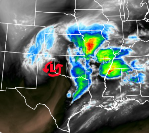
Look at this water vapor satellite picture above. This shows the upper level storm near the Texas/Oklahoma border this morning. As this storm tracks to near the Missouri/Arkansas border a comma head will redevelop near the Kansas/Missouri state line. That is a lot of state lines! The track of this storm seems to be perfect for a heavy band of snow in this comma head. If it does change to snow, then 2" of snow per hour is possible for three to six hours. Add that up! That would be 6 to 12 inches of snow. Again, that is if the temperature drops to near 32 degrees. If it is 35 to 37 degrees then it will be rain with snowflakes mixed in.
This storm is also producing a set up for a major severe weather outbreak:

The forecast is for conditions to become favorable for strong, long-track tornadoes from northeast Louisiana through northern Mississippi, into western Alabama. We will be monitoring this as well today. This part of the pattern will cycle through two more times, according to the LRC, this spring. April 27th to May 4th will likely see this extreme severe weather risk again, but farther north and west which may include our region in the next cycle.
The new data is coming in:
I will do a Facebook Live this afternoon and we will discuss the trend on these models and what we think will happen. Here is what we will be analyzing:
- Will we be in the comma head, and what does that mean? YES! We will be in the comma head tonight. At this time of the year, with this type of storm, being in the comma head almost always results in the location of heavy snowfall. The fact we are in the comma head tonight means we will have 1/2" to 1" liquid precipitation. If that is all snow, then that means 1 foot could fall.
- What will the temperatures be across the area? The temperatures are critical. It will be cold enough to snow 1,000 feet above us and higher. If we had a small 3,000 feet hill, or small mountain, that area would be getting the foot of snow. But, we don't have any of these mountains in our area, do we? So, the snowflakes will melt from 1000 feet above us to the ground. If it drops to 34 degrees or lower, 90% to 100% of the snowflakes will make it to the ground and 6" to 12" will be possible. If it is 35 degrees, then 50% of the snowflakes make it to the ground and it is a slushy inch of snow or so. If it is 36 degrees or warmer, and some of the models have that, then there may be 20% of the snowflakes making it to the ground. This means that there would be no accumulation.
So, we will be analyzing all of this tonight! It is not easy for us meteorologists right now.
Thank you for sharing in this weather experience and spending a few minutes reading the blog this morning. If the snow does indeed begin to show up, we will be all over it. Stay with 41 Action News, & we'll keep you advised.
Gary
