


Good afternoon bloggers,
We will discuss the severe weather risks this week, really concentrating on Thursday, in today's blog. Let's begin with what happened 3-days after the EF-5 tornado in Joplin. It was around 11:15 AM and thunderstorms begin forming as an upper level low was approaching Kansas City. It is very rare to have morning severe thunderstorm with possible tornadoes, but this morning on May 25, 2011, ten years ago, was different. The sirens went off and I was suddenly a tornado spotter from my deck at the Links at Lionsgate golf course looking south at this scary rotating wall cloud heading right towards my house. Take a look:
Just two hours later, early in the afternoon, Sedalia, MO got hit by this:

Kansas City just barely missed this one, three days after the Joplin Tornado. And, right now, Kansas City continues to be in a record long stretch without a Tornado Watch. There has not been a Tornado Watch issued for the immediate Kansas City metro area counties since May 28, 2019. Tornado Season lasts until around mid-June, so time is running out this spring.
There are chances for severe thunderstorms this week, especially on Thursday. Let's take a look:


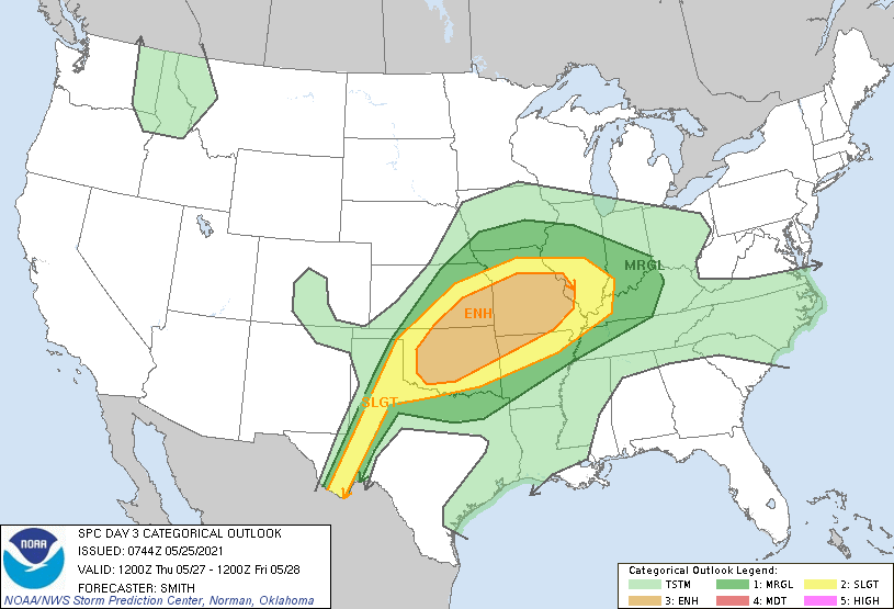
For Kansas City, it is rather ironic that the highest risk we have seen from the SPC is on Thursday. Two years ago we had the EF-4 devastating tornado that hit Linwood, KS on May 28, 2019. Last year we had a flooding event and a small tornado in Olathe that caused damage on May 28, 2020. And, now this risk is on May 27, 2021, one day before that big day.
Thursday's Outlook From the Storm Prediction Center:
"Scattered severe thunderstorms are likely on Thursday and Thursday evening from parts of the southern Great Plains into the Ozarks and middle Mississippi Valley. Very large hail, significant severe gusts, and several tornadoes are possible."
With very few risks so far this year, we can get a bit complacent. We should never get complacent when there are tornado risks, even though the chance of you being killed by a tornado is 1 in 4.5 million, according to the bookofodds.com. The chance of ever seeing a tornado is fairly low. KSHB meteorologist Jeff Penner just turned 51 years old on May 22nd. Jeff has never seen a tornado and he was born and raised in the Kansas City metro area. This shows that these are small, but they can be very deadly. The tornado is the most powerful storm on earth!
Thursday Morning Set-up:

The set up for Thursday may be majorly influenced by what happens Thursday morning. A morning complex of thunderstorms seems likely. If it is strong to severe, and large enough, it would end our severe weather risk after it passes. If it is weaker, then the afternoon thunderstorms will have a chance of organizing and becoming much more severe. In Kansas City, we often have ways of "getting out" of the higher risks of severe weather, and this is one way we may skate by and miss this significant risk. Now, there are many other possible scenarios. We will discuss these in tomorrows blog, and on 41 Action News tonight.
For today, we are expecting a cloudy morning. Showers and thunderstorm over western Kansas are only drifting this way. There is a chance of showers and thunderstorms later today. The severe weather risk is just a 1 out of 5 today, then it increases to a 3 out of 5 Thursday.
Thank you for spending a few minutes of your day reading the Gabbing With Gary blog. Have a great Tuesday.
Gary
