

Good morning bloggers,
I am just getting started.....I will finish this blog after my appearance on Sports Radio 810 AM in a few minutes at 7:55 AM. And, we will also update this blog around 10 AM after the new data has rolled in, so check in a few times today.
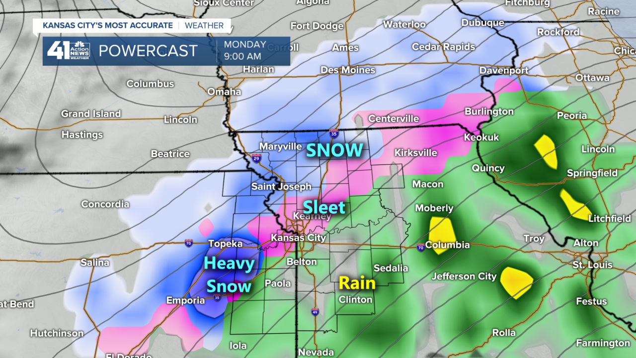
9:45 AM Update: A Look At The Snow Forecast From Various Models For Monday
- NAM Model: 6 to 10 inches of snow (6" in Clinton Missouri while other models cut the snow off one county south of KC)
- ICON Model: 3 to 5 inches of snow (No accumulation in Clinton, MO)
- RGEM Model: 3 to 11 inches of snow (No accumulation in Clinton,MO)
- GFS Model (due in at 10 AM): No Snow In KC with maybe a dusting north of I-70 (All the snow went north as a result of it being five degrees warmer)
- Canadian Model: This model had rain changing to heavy snow with 2 to 5 inches in the KC metro and more north and south (Clinton had 1")
- European Model: Rain changing to snow before ending. Total amounts: No snow south of I-70 and 10" up near the Iowa border
Note: The new data comes in every 6 to 12 hours and these model runs will look different by tomorrow, and again on Sunday!
We just had a high of 59 degrees yesterday. I hope you had a chance to enjoy it. I did get outside with the dogs a couple of times, and now it is back to winter. Colder air has moved in and we have a series of storm systems to track.
There is a huge game in Green Bay as the Packers play the Buccaneers in the NFC Championship game Sunday afternoon with a 2 PM kickoff on the frozen tundra, as they call it, at Lambeau Field. And, then the Kansas City Chiefs will host the Buffalo Bills with a 5:40 PM kickoff at Arrowhead Stadium. The first in the series of three storm systems will be zipping across the middle of the nation on Sunday. Isn't it awesome that both games are in the middle of the country and not on the coasts! I love it!!!

As we wake up Sunday morning, there will be a storm tracking across the plains into the Great Lakes states. It will be a fast moving and weakening storm. The impact will be felt more in Green Bay with snow likely early Sunday. And, then this frontal system will shift and move southeast and south.

Notice how it is mostly dry on this forecast map above, and this is valid during the first quarter of the AFC Championship game. There is a chance of some light rain that may have some impact on the game, and there is a decent chance of it being mostly dry with a northeast breeze. Farther north in Green Bay, the storm has zipped by, and there may be lingering snow showers, but even up there the weather impacts may not be that bad. It's still two days away, and this is how it looks right now.
NFC Championship Game In Green Bay Weather Forecast:
- Green Bay 31-27 over Tampa Bay
- There is a 100% chance of snow early in the day, and then just a few lingering snow showers later in the day for the game. High: 29° LIGHT WINDS are in the forecast for this game!
AFC Championship Game In Kansas City Weather Forecast:
- Kansas City 30-22 over Buffalo
- Cloudy with a chance of light rain showers during the morning. It will either dry out of some very light rain or drizzle with a northeast breeze at 5-15 mph during the game. Temperatures will be near 40 early in the day dropping to near 34 degrees by the 4th quarter of the game!
This first storm is not very strong, and still will be monitored closely. Look at what is forecast to happen just 12 to 18 hours after the games.
Monday's Storm System:
This Monday storm system has many different solutions from the weather models. They range from dry and no rain or snow, to over an inch of rain and 6" of snow. So, quite obviously this has our attention. I will write an update to the blog at the top of the blog after the new data rolls in.
For now, just know that it will be sunny and cold today, 23 degrees colder than yesterday's 59° high, with a high of 36°, and then clouds move in Saturday and we will begin monitoring these storm systems.
Thank you for sharing in this weather experience and spending a few minutes of your day reading the Action Weather Blog. We will be monitoring all of these weather changes and keeping you updated on KSHB.com and 41 Action News. Have a great weekend and GO CHIEFS!!!
Gary
