

KANSAS CITY, Mo. — Good morning bloggers,
We have tied two record highs this week. The high on Monday was 91 degrees, which tied the record set in 1963. We also tied yesterday's record of 92 degrees that happened in 1962. We will make a run at another record today as we are forecasting a record-tying 93 degrees, also set in 1962.
After today's near-record heat, it may not reach 90 degrees again until sometime in June. The air conditioners will get a little break beginning tomorrow and there are chances of some rain. The lawn and garden could use a nice drink of water.
By later tonight, a cold front will be approaching our area. This is not a strong front, but it will help cool things off a bit. As the front approaches, we will be tracking a line of showers and thunderstorms. Here is one of our models showing the activity heading towards us at 3 a.m.

This area of showers and thunderstorms will be forming near this front, the blue line. It turns into a purple line in northwestern Minnesota because it is a maturing and occluding storm. The purple line is an occluded front, where the cold front has caught up with the warm front.

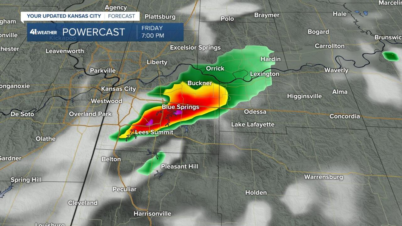
The trailing cold front will be weakening as it moves across our region. This is why I drew in the broken cold front by Friday night at 7 p.m.:

There is a chance of a few isolated strong or severe thunderstorms near this weakening front with large hail and damaging winds the main severe weather risks. This computer model shows heavy thunderstorms forming from Blue Springs to Lee's Summit by 7 p.m. Friday. Some of the models have it dry over the entire region Friday night while others have solutions like this one.
Storm Prediction Center (SPC) risk for the next few days:

Here is today's SPC outlook and the Tornado Risk below:

Storm chasers will be heading north again today. Any thunderstorms that form will be much weaker by the time they get to Kansas City. Here is our risk on Friday:

From the SPC: "Scattered afternoon and evening thunderstorms are expected Friday from the Upper Great Lakes to the southern Plains, with isolated stronger storms becoming capable of damaging wind/hail production. A few storms with limited hail/wind risk may also evolve over the Lower Mississippi Valley area."
Kansas City weather timeline:
- Today: Nearly 100% sunshine is in the forecast. We may tie the record high of 93 degrees with south winds of 10 to 20 miles per hour.
- Tonight: Partly cloudy with a 70% chance of showers and thunderstorms later tonight. Low: 69 degrees
- Friday: A 70% chance of showers and thunderstorms before 10 a.m. A few heavy downpours are possible near the state line closer to sunrise. There is a 20% chance of evening thunderstorms. If these form, there is a chance of a few severe thunderstorms with large hail the main risk. Light winds from the south shift to the north. High: 83 degrees
- Saturday: Partly cloudy with a slight chance of a thunderstorm. High: 85 degrees
- Sunday: Partly cloudy with south winds returning at 5 to 15 miles per hour. There is a slight chance of a shower or thunderstorm. High: 78 degrees
Thank you for spending a few minutes reading today's blog and sharing this weather experience.
Gary
