


KANSAS CITY, Mo. — Good morning bloggers,
While the Chiefs prepare for their last preseason game tonight, we are tracking a chance of late weekend thunderstorms, the quiet tropics, and some hot tailgating weather!
The quiet tropics as of this morning:

We are now experiencing one of the quietest beginnings to hurricane season ever over the Atlantic basin. We may go the entire month of August without a named storm for only the third time in the past 60 years.
There is a statistic called "Accumulated Cyclone Energy", or the ACE score:
- This year's ACE as of August 25: 2.8
- Average ACE score by August 25: 24.9
- Number of days with a named storm as of August 25: 3.25 days
- Average number of days with a named storm by today: 18.5 days
This season's activity is 11% of the average activity by August 25, or the quietest start to a hurricane season since the late 1980s. This season the Atlantic basin has had three weak named storms, Alex, Bonnie, and Colin, all of which happened before July 4. There hasn't been a named storm since July 3 when the weak Tropical Storm Colin fell apart a few hours after it was named, or 53-days without a named storm.
This quiet period continues today. Weather 20/20 made a prediction that it would be a quiet season, as opposed to all other forecasts being tracked which had predicted another wild hurricane season. Why has it been so quiet? The LRC is the reason why. The first signs of this quiet hurricane season appeared in October and November when last year's hurricane season suddenly ended quietly after a stormy season up until October.
The LRC also provided the insight and methodology/technology to make this prediction of our main target of the season:
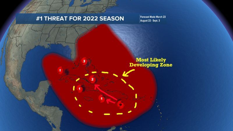
I made this graphic last March. Now, look at the overnight GFS (American Model):

The GFS model has had predictions of around a dozen hurricanes already this season. This model has been highly unreliable up until this point in the season. Now, this one showing up and forming just over a week from now has a better chance of being accurate. Why? Again, because of the LRC. Notice where that Low is forming, a potentially named storm. It is forming near the predicted formation/developing zone I drew in five months ago.
I drew in two possible tracks for this potential tropical system. Let's see how the models come in during the next week. Remember, it has been a very quiet season so far, and it will likely end up below average as predicted. There is still a chance of an impacting storm in a quiet year.
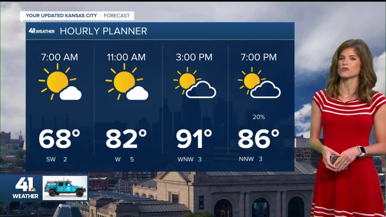
Kansas City Weather:
The weather is looking nice for tailgating out at Arrowhead this afternoon, but put on the sunscreen. A few clouds may be building up with any chance of rain less than 10%. It will be hot with a high of near 92° today.
Between Saturday and Tuesday, we are seeing a good chance of rain with heavy thunderstorms possible. We will time out the rain chances on KSHB 41 today and tonight. Here is one of the rainfall forecast from that same GFS model that showed the potential tropical system:

This shows 1-4 inches of rain in our area ending Tuesday morning. The best chances are late Saturday night and late Sunday night, and possibly late Monday night. One, two, or all three of those time frames will have some thunderstorms in our region.
Thank you for sharing in this weather experience and spending a few minutes of your day reading the weather blog. Have a great Thursday!
Gary
