

Good morning bloggers,
Rain developed early this morning and became wide spread. This is the first wide spread steady rain in month and a half, or 43 days. The rain will end later this morning and the sun is likely going to blast out this afternoon. And, then a cold front will move through.

Before the cold front moves through, we have a window from around noon to 2 PM where we may make a run at 60 degrees again today. This rain will be ending from west to east in the next few hours.

Colder air will stream in tonight, but this is not the Arctic Blast that is now in the weekend forecast. This first cold surge tonight will drop temperatures into the 20s tonight, and that is still above average. The average low is now near 20 degrees.
There is also a fast moving disturbance that may produce a band of snow north of KC. Take a look at this:
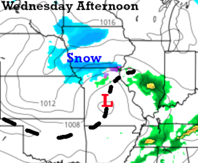
There is actually a chance of 1" of snow near Maryville tomorrow. We will monitor this closely in case it tracks just a bit farther south. And, then this is forecast on the overnight data:

There is a trend into a much larger winter storm that would end our snowflake contest and possibly more. The snowflake contest will end when 1" of snow is measured in front of the KSHB-41 Studios. This is our first chance of snow of the season.
I would like to wait another few hours before we go in-depth into this snow possibility as there are still too many questions. It did trend into this more organized winter storm, but will this trend continue today. You know I will get fairly excited if the trend continues. So, this discussion will become much more serious in the next few hours if the trend continues.
What we know now:
- It's raining early this morning (I just needed to start with this since it hasn't rained in a long time). This broke the ice and now the storm system this weekend is suddenly looking a bit more organized
- The storm system in question for Saturday is still way off the west coast
- There is a trend towards a stronger, more organized winter storm system Saturday. Will this trend continue? If it does continue, then we are now going to be within three days or so of it approaching, and we can analyze it a bit more deeply
- There is a chance of a little strip of snow just north of KC tomorrow
Arctic air will likely blast in in the wake of this storm. Temperatures will drop into the single digits Saturday night.
Thank you for spending a few minutes of your day reading the weather blog and sharing in this weather experience. Have a great day!
Gary
