


KANSAS CITY, Mo. — Happy November blog readers.
October has come and gone. The rundown overall was that it was a warm and uniquely wet month that ended with record cold.
We closed out the month with a high of 41 degrees on Halloween. That pushed the holiday into the top five for coldest Kansas City Halloweens.
But according to KSHB 41 Meterologist Jeff Penner, that didn't seem to matter to those trick-or-treaters.
It may be 30-35 degrees outside side. But it has not affected candy collection! At least the wind has become light. Trick or treat! @KSHB41 pic.twitter.com/tqwa9Vrt2t
— Jeff Penner (@JeffPennerKSHB) October 31, 2023
The cold air settled in fast overnight and Kansas City dropped to 18 degrees by Wednesday morning, breaking the record for Nov 1. It has been 227 days since we felt teens in the morning. The last time it was in the teens was March 19, 2023, when it was 14 degrees to start the day and 44 degrees to end it.
November is officially here and we are kicking it off with a record cold start. @KSHB41 pic.twitter.com/CBepWBL4i5
— ☀️ Cassie Wilson (@CassieKSHB) November 1, 2023
We weren't the only ones kicking off the month at or near record cold; at least a couple dozen other cities across the Midwest were in the same shivering state.
Did you know the most cold records in a single day have fallen in the month of November? This is a month notorious for big weather swings.
Back on Nov. 13, 2019, 258 daily low records fell. Do you remember that cold outbreak?
Kansas City wasn't the only spot kicking off November cold. Take a look at all the cities across the Midwest and south that were also shivering this morning @KSHB41 pic.twitter.com/eFvkemURdm
— ☀️ Cassie Wilson (@CassieKSHB) November 1, 2023
Nov. 1 also means that the climate data for the month of October is ready to be analyzed. Here's where the month broke down, it was warm and it was wet. Well wet in a weird way.


While our temperatures all trended above normal, they weren't all that crazy.
Statistically speaking, they were in the 44-45 percentiles, so slightly warmer than normal, but still warm nonetheless. When it comes to rain, October wasn't a wet month overall as we saw majority of our rainfall occurs in just five days.
- Oct. 10: 0.3"
- Oct. 24: 1.13''
- Oct. 25: 1.10"
- Oct. 26: 0.25"
- Oct. 28: 0.49"
Those last four days account for 2.97'' or the 3.47'' we saw that month with our active streak last week.
I know many of you at home saw some pretty big totals out of that stretch of wet weather with some locations receiving over 6" of rain in just three days. You can really see where that storm hit when you look at our 30-day percent of normal map.
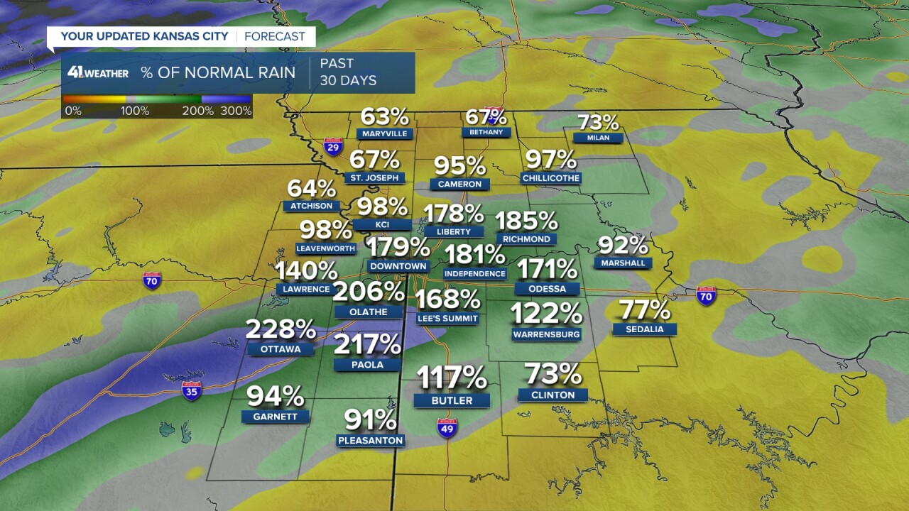
The purple and green streak into downtown really took the bulk of the rain. And you can see those outside the zone didn't fair too well when it comes to October rainfall.
Just north in places like Atchinson, the month closed out drier than normal at 64% of rainfall for the month.
As we look ahead to November, it's important to note that November as a whole is typically a drier month that October and we start to see colder temperatures with less daylight.
November averages 2.0" of rain and 1.1" of snow. The rainiest month for Kansas City is May, with 5.32'' and the snowiest month is February with 5.9''. Here are some other fun facts about November:
Welcome to November!
— Mike Nicco (@MikeNiccoKSHB41) November 1, 2023
We began today with a record cold minimum temperature of 18°. More on that in another post.
Wondering what to expect during November?
It's our 4th coldest & 4th driest month.
Check out the graphics below for more details & that record snow!@KSHB41 #KCwx pic.twitter.com/2tBMHoiNix
Do you have snow on your mind, your KSHB 41 weather does. We are currently all calculating snowfall projections for the winter season in anticipation for our winter weather special set to air Nov. 29.
So mark your calendars now and make sure to tune it! We've got a really great show lined up.
—
