

Good morning bloggers,
Hail will be the topic of today's severe weather awareness report. It is severe weather awareness week and our weather team is working on our severe weather special which will air later this month. Hail forms in a violent process within a cumulonimbus cloud. A small hail stone will develop quickly when rain drops are forced to rise up to the freezing level and then they fall to the ground as a pea sized small hailstone. If the updraft is stronger, then these pea sized hailstones get forced back up into the freezing level where they accumulate a little more water from the raindrops in the environment. They freeze again into a larger hailstone. This process continues over and over again and when the updraft is no longer strong enough to bring that hailstone back up, it will fall to the ground. If you open up a hailstone and cut it in half, you will see layers. Each of these layers is a time it violently went up and down inside that thunderstorm or cumulonimbus cloud.

A hail stone is considered severe size when it reaches the diameter of a quarter, or around 1". When they get to this size, they can cause serious damage to agriculture crops and automobiles. We will issue a severe thunderstorm warning if we believe the hail may become that large.
We have no chance of hail today. We have no chance of rain for a while. A storm is approaching Southern California, and this one will miss us to the south. The next significant chance of rain is showing up in just over a week or so, and it may bring our first chance of thunderstorms in 2021.
Precipitation and Temperatures from October 7 - November 7:
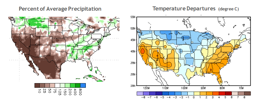
When this year's weather pattern set up in October it was dry in Kansas City and it was cooler than average. The maps above show roughly the first 30 days of this years weather pattern. The LRC sets up by around the first week of October each fall, and then continues through the next September. The pattern is cycling regularly. We will be using our knowledge of this cycling pattern, of the LRC, as we let you know which dates are most likely to have severe thunderstorms this spring. We already have one big target date range in the first week of April, and again in mid-May to May 20th or so. We will discuss this in our weather special later in the month.
Precipitation and Temperatures In The Past 30 Days:

Precipitation and Temperatures In The Last 90 Days (Meteorological Winter):

As you look at the last 30 days, it shows our region as slightly below average temperatures and near average on rainfall. This will likely be the continued trend through spring. We will discuss more on this trend in tomorrow's blog.
The weather forecast for today through Thursday is for highs in the 60s. It will be sunny and warmer today with a forecast high of 62°.
Thank you for spending a few minutes of your day reading the Gabbing With Gary blog, Have a great day!
Gary
