

Good morning bloggers,
This will be a running blog with updates through the morning. We had a quick band of thunderstorms move across Kansas City around 4:30 AM, and a second round was approaching as I started this blog. Let's take a look:

The area of thunderstorms has weakened, but it is going to rain throughout the KC metro area between now and 9 AM, and then it will dry out. This is good news for the Hollywood Casino 400 race. There may be a brief shower during the race causing a small delay, but it shouldn't be a major problem
Here is the radar as of 6:45 AM:

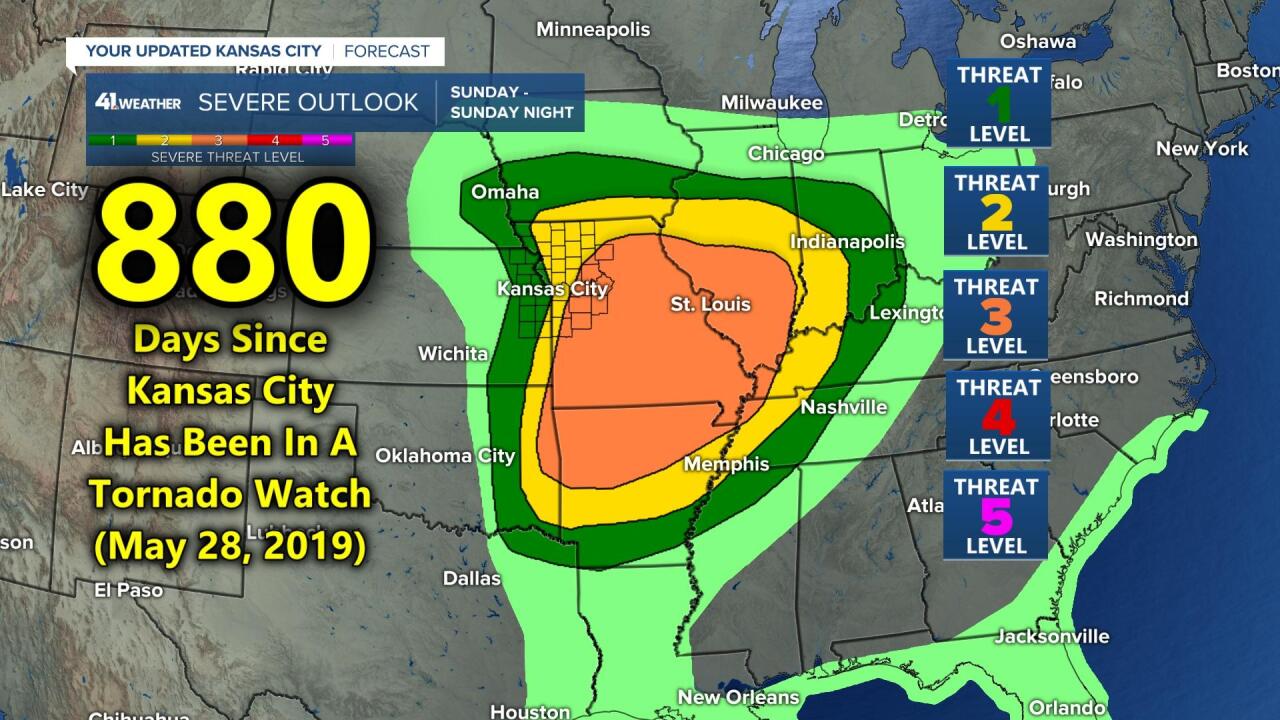
There is a level 3 out of 5 risk of severe weather in our area per the Storm Prediction Center (SPC). It has been 880 days since our last Tornado Watch and that streak may continue with the main risk east of KC:
Some of the models keep KC dry after the morning area of thunderstorms moves by. Here is the set up as of 6 AM:

The warm front was on our doorstep at 6 AM. We will go into the warm sector, which is the area between the warm front (red line) and cold front (blue line). And, then the cold front will move through Kansas City by around 4 PM. As it approaches there will be a very short window that will open and close for around two hours this afternoon. Thunderstorms may form around 3 PM along the cold front, but by 5 PM the front will likely be well east of KC ending any risk of severe weather. So, we have to pay very close attention to this developing line.
The Updated Models:
As you can see below, and this is quite interesting, the front is already forecast to be past KC. Now, I say the front, as we will have two frontal passages today. The red line, or warm front is going to pass through as the rain ends soon. You will notice a warm and humid surge to the air outside later this morning. And, then the second front, the blue line or cold front, is forecast to move past the state line by 3 PM. If this is the case, then it will be dry out at the Kansas Speedway, and the risk of severe weather will be way off to the east:

This next map shows the front and risk of severe thunderstorms out of our viewing area later today:

This system is forecast to move by very fast, and by 6 PM the risk is already approaching St. Louis. This likely means our streak without a Tornado Watch will continue in KC, but we still have to monitor the front as it zips by around the end of the Chiefs game today.
Look at what is happening next:

These two maps show the flow around 18,000 feet above us. We call this the 500 mb flow, and we use this level to find the main storm systems. Today's storm is intensifying as it passes us as an open trough. Since it is still an open trough, it is moving very fast and it is causing our severe weather risk to push off to our east quite quickly. Look at the major storm off the west coast, and there is a hurricane, Hurricane Rick, being picked up by this major storm. Look at what happens by Wednesday:

The major storm coming into California, which will produce 5 to 10 inches of rain and very heavy snow at high elevations, will be carving out a major storm near Kansas City by Wednesday. This will bring us a 100% chance of rain, possible thunderstorms, and colder air by Wednesday afternoon. it is still too warm for any snow chances. It has snowed in three straight Octobers, and this storm is the type of storm that can do it, but it will be way too warm in this first LRC cycle. When this part of the pattern cycles back through in December, it may very well be a major snowstorm. So, remember these two storm systems as they are in this year's cycling pattern that has started out rather fascinating.
Kansas City Weather Timeline:
- Now through 9 AM: Rain and a few thunderstorms will track through and then end. Temperatures near 60 degrees
- 9 AM - 3 PM: Dry with the wind shifting to the south and warming up into the 70s.
- 3 PM - 6 PM: The front blows through with the wind shifting to the west and northwest and quite gusty. Temperatures will drop into the 50s. There is a 20% chance of a brief thunderstorm with the risk of severe weather on the east edge of our viewing area. Kansas City has a small chance of severe thunderstorms as the front blows through.
We will be monitoring this set up closely. Again, it appears the best chance of severe weather will be way off to our east. There is a small window that will open and close fast as the front blows through.
Thank you for sharing in this weather experience and spending a few minutes reading the weather blog. Have a great day!
Gary
