


Good Tuesday bloggers,
We had a red sunrise today as there is more smoke in our air than there was on Monday.
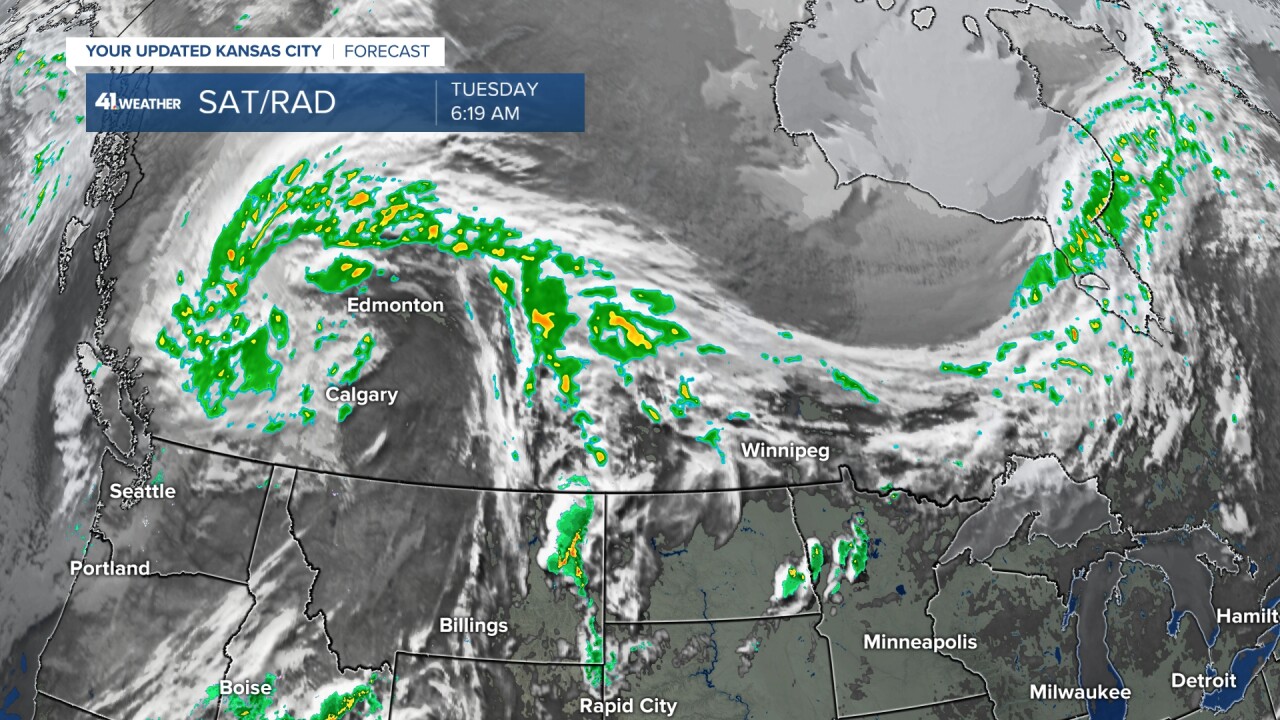
Yes, this is smoke at about 20,000 feet from the western Canada wildfires. A storm system is bringing much needed rain to western Canada. This will certainly reduce the fires, but the smoke is still all over the USA and Canada. It will take awhile to lower the smoke amounts even with much less fire activity.
Now we have two items to discuss. First, we have an update on severe weather season. Are we done with big severe weather threats? Second, we look into Memorial Day weekend. It is on average the wettest weekend of the year. It is very tough to keep it 100% dry all three days.
SEVERE WEATHER SEASON 2023:
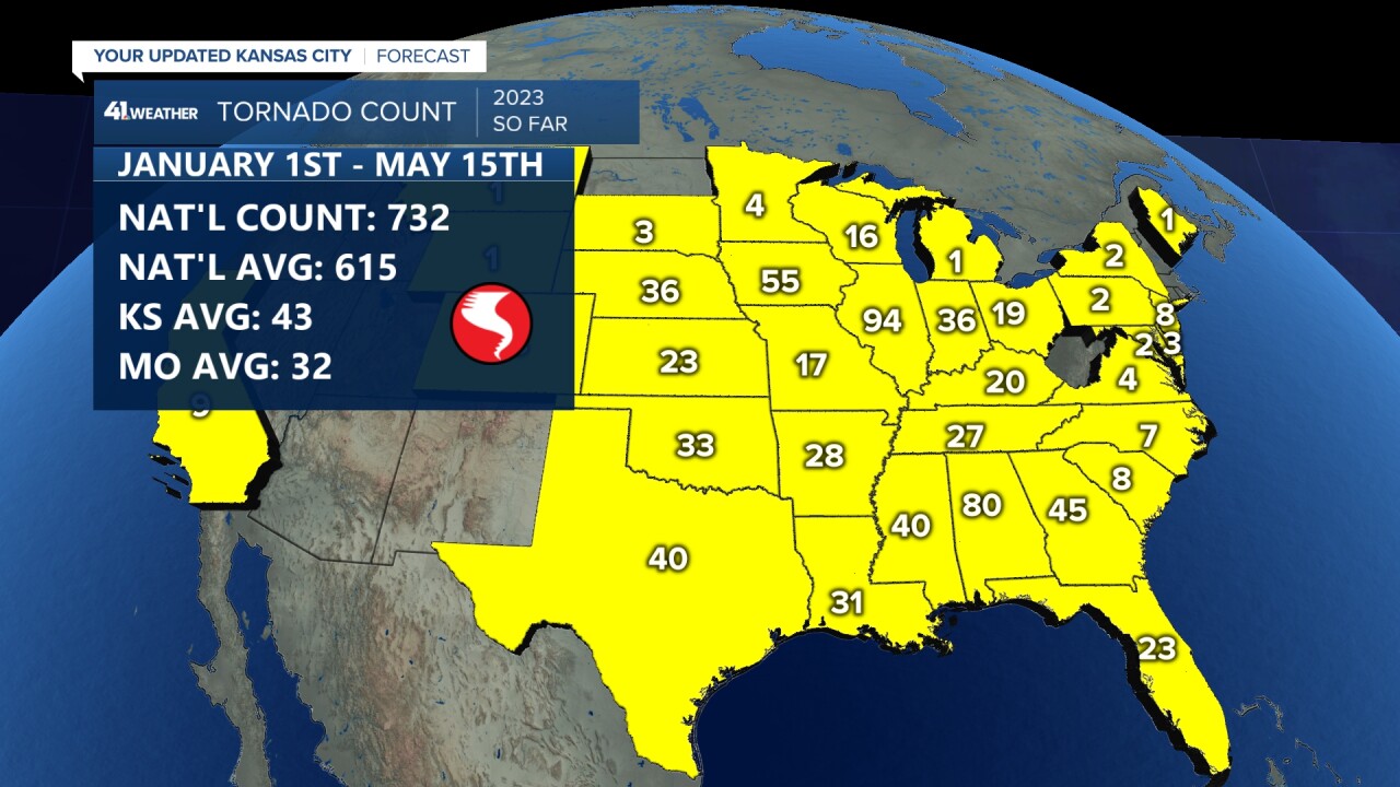
These are the tornadoes by state Jan. 1-May 15.

It has been an active season nationally with 732 tornadoes as of May 15th. Average is 615 by May 15. Kansas and Missouri are running below average which is a good thing.
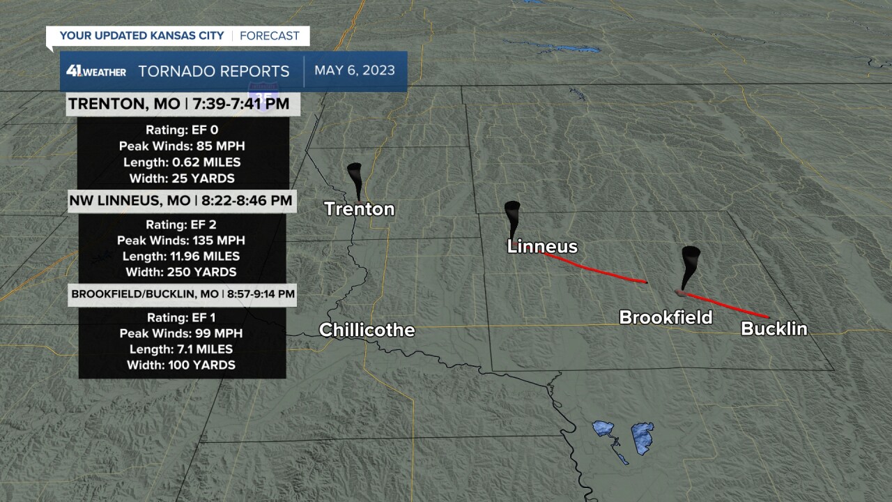
In our area May 6 was the day when we saw the most significant severe weather in our viewing area with three tornadoes in northern Missouri.
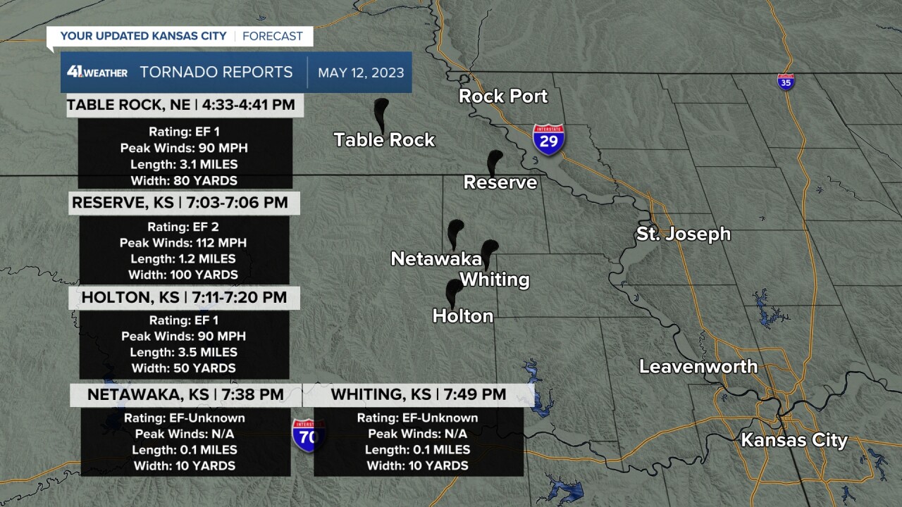
May 12 there were four tornadoes from eastern Kansas to southeast Nebraska, just west of our viewing area.
May 6 and 12 are the only days this season where tornadoes have been in or near our viewing area. We had large hail on the south fringe of the viewing area May 8 in Bates and Henry counties. Then, we had hail and wind on the southwest side of the viewing area May 9 for cities like Ottawa and Emporia in Kansas.
May is on average our month with the best chance for severe weather. But, it depends on how the weather pattern has set up. We showed the below severe weather calendars during our Spring Special in early March. When we showed this we made the point that severe weather will not occur on all these dates. But, they may occur just in or out of our region on these dates. And that these red blocked out dates mean it is that period where we have to watch for severe weather.
How did we do?
May 1-4 there was minimal severe weather in the western Plains.
May 5-7 saw quite a bit of severe weather less than a state to our north. We were just one day off from our biggest severe weather day of 2023 so far, the May 6 tornadoes in northern Missouri. The May 6 tornadoes were the southern edge of the bigger outbreak.
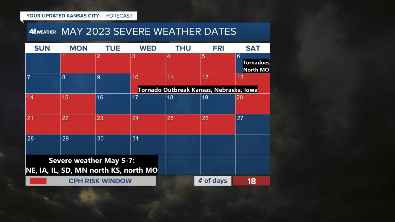
The May 10-15 period verified well. We had the hail and wind in the south and southwest viewing area May 8-9, but May 10-13 there was a full blown severe weather outbreak just west and northwest of our area.
The last period we blocked off, May 20-26, is not really materializing around here. But, there has been and will be some severe weather in the western Plains.
The main jet stream has retreated way to the north into Canada where it usually is located from the end of June through August. Our severe weather season ends around June 15 due to this fact. You can get severe weather during the summer, but it is usually not as bad due to weaker flow aloft.
Well, since the jet stream has retreated early, it is shutting off the severe weather threats this week.

What about June? See the calendar below that we also showed during our Spring special in early March.
We have June 7-13 and 20-24 blocked off. If the jet stream stays in Canada, then we will not have much severe weather to deal with. Could the jet stream come back south? Yes, it can in a temporary way. So, we still have to watch these periods. Otherwise, most of severe weather season is behind us and most rain and thunderstorm chances from here will have little to no severe threat.

————————————————————————————————————————————————————
WEATHER TODAY THROUGH MEMORIAL DAY:
Now, let's look at the weather through Memorial day. We have nearly a 0% chance of severe weather in our area.
Today will see afternoon cumulus clouds, noted by the white dots with highs around 80°. Organized thunderstorms will occur from Colorado to Oklahoma.

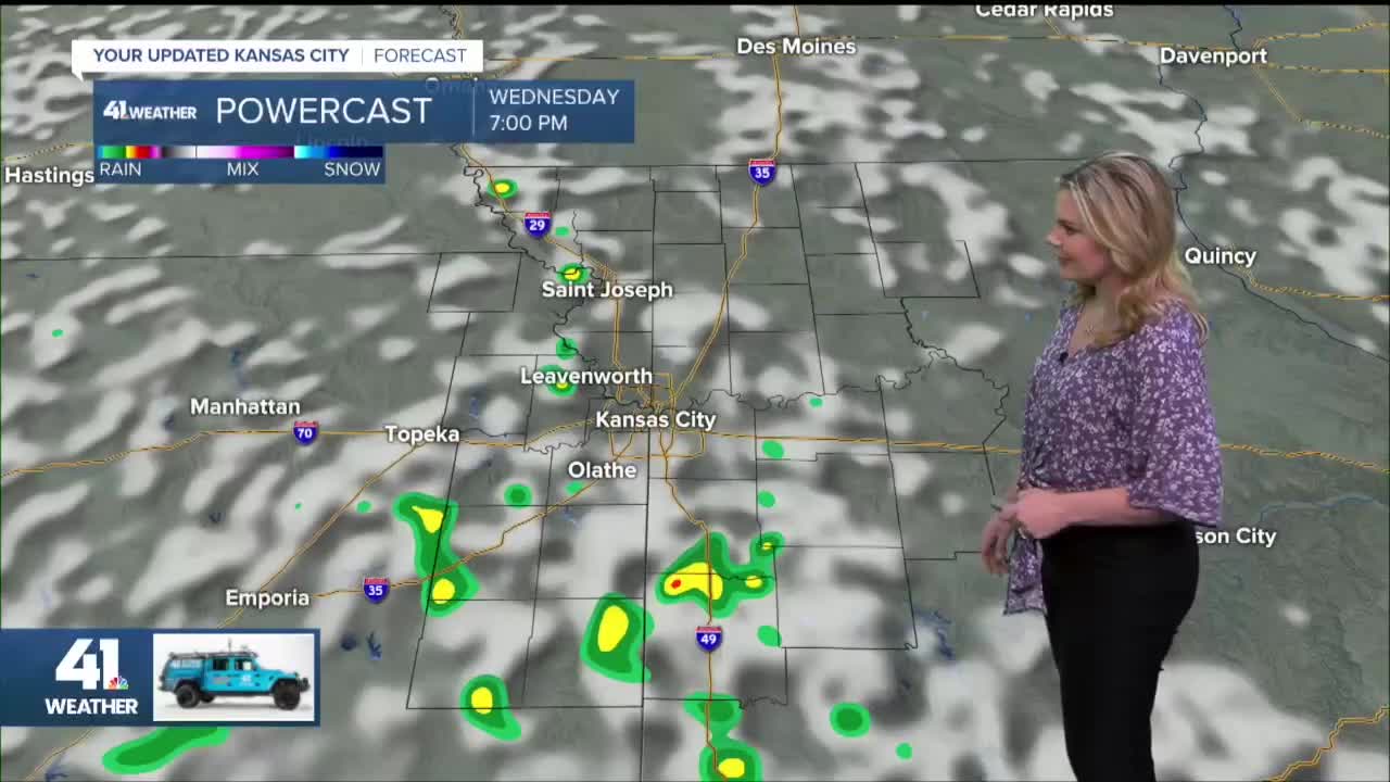
Wednesday we will see cumulus clouds build, but some may become cumulonimbus clouds. This means we have a chance for scattered showers and non-severe thunderstorms. If you get underneath one, you may receive around .25" of rain, perhaps .50" and a 30 mph wind gust. The timing of any showers and thunderstorms is mainly noon-8 p.m. Highs will be around 80°.

Thursday the scattered shower and thunderstorm pattern may remain as it shifts west. We will be watching a cold front coming in from the northeast. This is called a "backdoor" cold front as it is coming in from the northeast and not the typical northwest or west.
This front will play a huge role in our Memorial Day weekend forecast. If the front pushes west into the western Plains we will see slightly cooler air, but more importantly much drier air. This will shut off any chance of scattered showers and thunderstorms.
If the front decides it wants to stall near or east of here, the humidity will stay higher and we would have a daily chance for scattered showers and thunderstorms through Memorial Day.

We are leaning with the dry scenario. So, between now and Memorial Day there will be heavy rain in the western Plains while we see none to .25", perhaps .50" in a few locations. And, our main rain is timed for Wednesday and Thursday.

So, here is our Memorial Day weekend forecast. Right now it looks great with lows 55°-60° and highs 80°-85°.

Have a great rest of your week, stay healthy.
