


Good Monday bloggers,
It is no secret we need rain as drought conditions are growing in Iowa, Nebraska and Missouri. Northeast Kansas and northern Missouri are still in a level 1 or no drought. But, things are drying out quickly in those locations. The soybeans and some corn could really use one more nice drink of water.
We have a set up tonight and Tuesday where a storm system will be tracking northwest to southeast from Nebraska to Missouri along and behind the cold front that came through Sunday and stalled. This is a set up for about a 100 mile wide zone of heavy rain, 1"-3". We have numerous models we look at and as usual the forecast for KC is not easy as we are on the edge.
Below I will show you the varying data and then come up with our latest thinking. Here we are 24 hours or less before the weather event and it is still not set yet. Amazing and welcome to KC.
RAINFALL FORECAST AMERICAN MODEL:
Our area is mostly in .10-.50", but we are in it. This model has been trending west and a bit wetter.

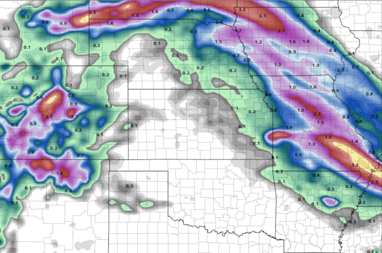
RAINFALL FORECAST EUROPEAN MODEL:
This model has consistently shown the heavy rain just east, but the western edge has varied from the state line to 80 miles west of the state line. The latest data, as seen below, has the western edge near the state line.

RAINFALL FORECAST NAM MODEL:
Our area is mostly in .10-.50", but we are in it. This model has been trending west and a bit wetter.
RAINFALL FORECAST RGEM, MODEL:
This model has KC in .10-1", but offers a solution a bit different. It has the heavy rain in two areas, along and east of the state line and southeast Kansas to southwest Missouri. This puts KC in the minimum.

RAINFALL FORECAST UKMET MODEL:
This has the solution like the RGEM above.

RAINFALL FORECAST CANADIAN MODEL:
This is similar to the RGEM and UKMET, but the southern band is weaker. KC is still in the least.

RAINFALL FORECAST HRRR MODEL:
This is the outlier at this time as it has a solid band of heavier rain from southeast Nebraska to northeast Kansas to much of Missouri, putting KC in some beneficial rainfall totals.

So, what is our latest thinking?
- If you live 20-100 miles north, northeast, east and southeast of KC you have a good chance of seeing a 1"-3" rainfall event tonight and Tuesday.
- If you live in KC or 20-100 miles west of KC you have a decent chance of rain, but amounts may be in the trace to 1" category.
- If you live 20-100 miles southwest and south of KC you have an increasing chance to see .50"-2" of rain.
- Now, all this being said, nothing is set yet. The HRRR, outlier solution, is still possible. Or, one of the other solutions shown above gets shifted west or east by 50-100 miles.
- The bottom line, we will see a beneficial rain event in the region as no matter where it rains, it is needed. You can see the latest drought monitor. All of the above solutions will impact a drought area. The locations not in a drought level are in need of rain yesterday. Also, we do not expect severe weather. If there is any, it would be isolated and perhaps a strong wind gust or some hail.
- The good thing is that we have rid ourselves of the high heat with highs Tuesday in the 70s, 60s in heavier rain areas. Wednesday into the weekend we will see highs mostly in the 80s.
- There are also 2-3 rain chances between Friday and next Monday. So, the rain tonight and Tuesday is not a one and done.

Have a great week and here is hoping your yard or farm gets a soaking.
Stay healthy.
