


KANSAS CITY, Mo. — Good morning bloggers,
Sunny and Rainbow the weather dogs got out early this morning when the wind chill was 15 degrees below zero. Ouch! Even they only wanted to spend a couple of minutes outside. The sun is out today and we will have a nice winter day as the wind calms down and temperatures warm into the lower to middle 20s this afternoon.
A winter storm is approaching and this one will get its act together as it is passing by on Thursday night. Even though it looks like the heavier snow will increase east of Kansas City, even one inch of snow will likely cause all kinds of slick and hazardous conditions.
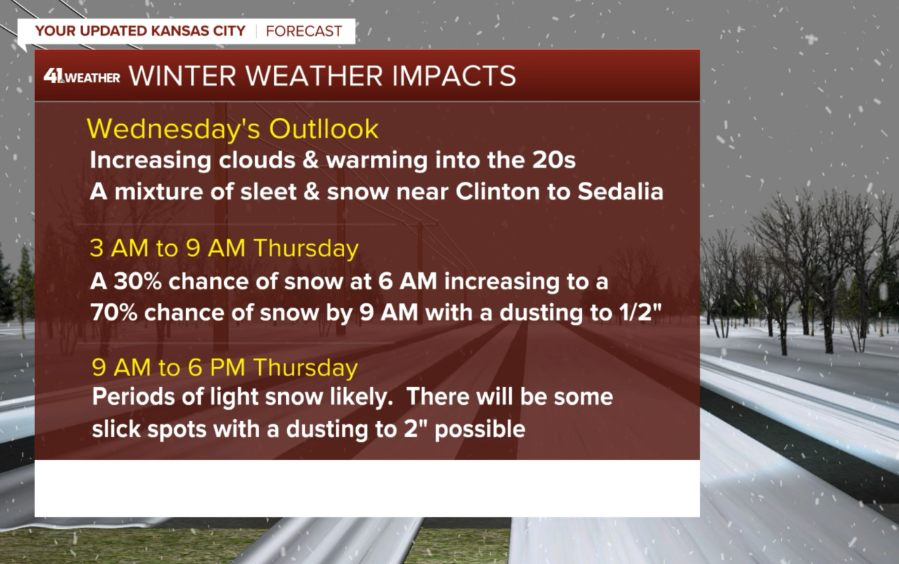
Snow is in the forecast for Thursday! Now, if you know me and my forecasting style, then you know I love to go 100% chance when I am at all confident of it raining or snowing. We placed a 70% chance of snow for Thursday on the Super 10-Day forecast 10 days ago for this system. We still have a 70% chance in there. This means that seven out of every 10 times I tell you there is a 70% chance it will snow or rain. This also means that three out of every 10 times we forecast a 70% chance of snow or rain, it will not snow or rain. So, there are still a few factors that could keep us dry on Thursday. My confidence may go up to 100% soon, but as of this writing, I am still at 70%. Dry air is a factor, and there are a few other questions about when it will start and how much will fall. I will go over the models in just a second.
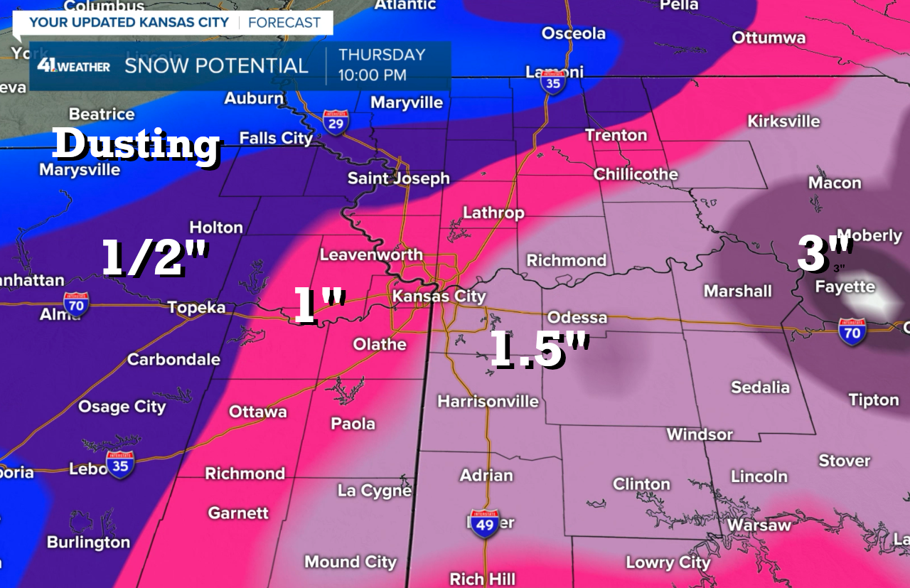
The white area is showing 4 inches or more snow accumulation with our area in lower amounts.

Lincoln, Nebraska, has had under 4 inches of snow for the entire season, and it appears this one will leave them with a dusting at best once again. Northwest Missouri is also in the dusting category with higher amounts possible as you head south and east.
As I zoom into our local area, I plotted the snow potential based on everything we have analyzed. Forecasting 1 inch of snow is very difficult. For example, yesterday it snowed all day and I was not expecting that to happen. But, it ended up only being a trace of precipitation after 12 hours of snow. It literally snowed from around 9 a.m. to 9 p.m. and there was no measurable precipitation. So, a 0% chance of measurable snow yesterday would have been an accurate forecast. At the same time, perception would say there was a 100% chance of snow yesterday. Again, when we predict precipitation, we are predicting the chance of measurable snow or rain, which is 0.1 inch of snow, or 0.01 inch of rain. The best forecast for yesterday would have been for snow showers likely all day with no measurable amounts. That is hard to explain, but that would have been a great forecast.
So, this forecast is different for tomorrow as we are expecting light amounts. It will likely be around 0.01 to .15 inches of liquid total for a snow amount of a dusting to up to 2 inches.
New data analysis:
Let's look at the models.
Here is the first model in this morning. The pink area is showing light freezing drizzle. There is a chance of a light glazing of freezing drizzle early tomorrow morning. It isn't much, but it may begin with that precipitation type.

The models:
- HRRR: This model came in this morning with that freezing drizzle to start and then it changed to a light snow with a dusting to 1 inch in the area
- NAM: It has a dusting to 1/2" widespread over entire area with snow beginning around sunrise. This is a very low snowfall event modeled. The NAM 3K was similar with 0.1" to 0.5" amounts, which is really a glorified dusting.
- ICON: This one came in about the same with a dusting to under 1" in most areas
- GFS: This model has been the most aggressive and it just backed off to a dusting to under 1"
- Canadian: This model has widespread 1/2" amounts
- European: The Euro has exactly 1/2"
Our forecast is for freezing drizzle and light snow to form around sunrise Thursday and produce around a dusting to just under an inch of snow.
I will fill in the model data as it arrives. For now, enjoy today. I am actually going to a concert tonight in Independence. I am going to see Volbeat, one of Andy's favorite bands, and I have enjoyed their music as well. I will have the blog updated early on Thursday morning.
Thank you for spending a few minutes of your day reading the blog and sharing in this weather experience. Bundle up and have a great day.
Gary
