

KANSAS CITY, Mo. — Good morning bloggers,
A winter storm is developing and approaching our area. And then again, at the same time you get to enjoy a spring-like day with winds, humidity increasing and temperatures warming into the 60s.
There are a lot of questions still, even at less than 24 hours before snow spreads across our region. The biggest question for me is rather meteorological: Will the upper-level storm hold together, and where exactly will it track.
500 MB (18,000 feet above us) forecast valid 6 p.m. Wednesday:
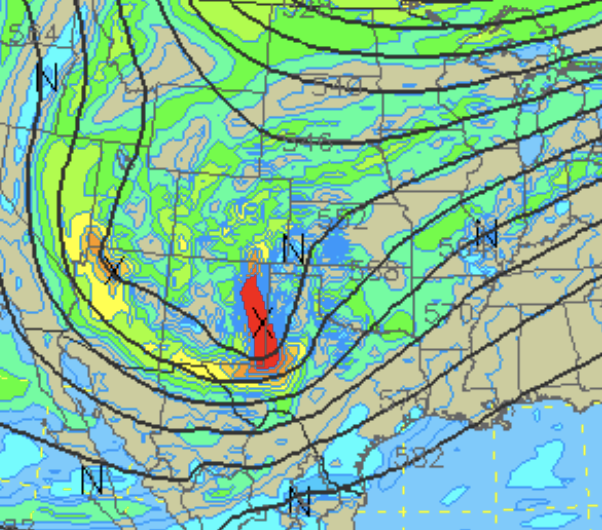
These two maps show the upper-level flow around 18,000 feet above us. This is the 500 MB (millibar) level, or around halfway up through the atmosphere in weight. The surface has a pressure (the weight of the atmosphere above you) of around 1,000 MB. The top of the atmosphere has no weight, so 0 MB. MB stands for "millibar," a measure of pressure. So, 500 MB is halfway up, and it just happens to be around 18,000 feet up there. This is a great level to track these storm systems.
On this map above, and this one below, look at the red area, and the black X:

The disturbance holds together as it takes a track south of Kansas City. Notice the tilt of the red area from just south of Kansas City to northern Oklahoma and that X.
- The models that have the heavier snowfall and farther north position are doing that because this solution maintains the strength and tilt of that storm.
- The models that have lighter accumulations in our area and much farther south on accumulations are stretching this disturbance out, what we call shearing, and this forces the area of snow south.
I will be looking for this disturbance tonight. We have upped totals a bit based on a blend of all of the solutions. And, colder air is approaching, as you can see on this 7 a.m. surface map:

The cold front will arrive before sunset and track across the entire Kansas City viewing area by 10 p.m. Temperatures will drop to below freezing by around midnight. Now, when will the precipitation begin?
HRRR Forcast valid at midnight:

This first data in early this morning shows the storm still not getting its act together by midnight. There is a band of rain, with possibly a thunderstorm or two, southeast of Kansas City.
Look at what happens seven hours later at 7 a.m.:

Five hours later, this model has Kansas City in the comma head with the south side getting the most snow:

This model does produce nearly a foot in the heaviest band. We do not see evidence of this happening yet, so this is not our forecast. We are predicting Dusting to 4" low, and 2" to 8" high end at this moment. You can see that below. I may see evidence by 6 PM or 9:30 PM tonight. Yes, our newscast is on at 9:30 tonight in a window that the Olympics on NBC are providing us. If there is any evidence of more or less snow, we will update the forecast. This is how it is with every precipitation forecast, rain, sleet, freezing rain, or snow. We update. It is just that a snow forecast is just so much more impacting, and it gets criticized way too much.
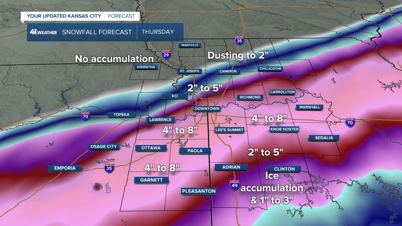
Snowfall forecast:
Please look at the low end of the range closely. The low-end numbers are a dusting to 4 inches. The higher-end shows 2 to 8 inches. Some models have a foot of snow in the area, so we are going to monitor closely to see if that higher-end is worthy of being taken seriously.

Snowfall forecast from the models:
- HRRR: This first model this morning has been one of the most aggressive. It produces a band close to where our forecast band is and almost doubles our totals. The amounts across the Interstate 435 loop range from 6 to 14 inches on this model. I don't see evidence of the higher amounts. If we see any evidence, then we will up our totals, but right now there isn't any evidence. It would be like us predicting thunderstorms. Where will they form? And, then they form and they are farther south and it affects totals.
- NAM: This model has a high resolution and a low-resolution version. The high resolution trended to lower amounts but still has the ranges in our forecast. It has 3 inches near the Kansas City International Airport to 8 inches near Lee's Summit. The trend is south. And, the storm I talked about above, weakened and stretched out. One more little stretch and it will shift even farther south.
- ICON: This model just came in with the northern edge north of KC. It has widespread 5" to 8" amounts.
- GFS (American): The American Model has widespread 5-10 inch amounts through the KC metro area with the highest southeast and south of KC. The snow begins around 6 AM on this model.
- Canadian: The Canadian went up after days of keeping it low. It went up to widespread 4-8 inches.
- European Model: The Euro was a bit farther north and a bit more snow. It was still the lowest model total and still had 3" to 6" across the KC metro area.
The timing on the impacts of this storm are sliding closer to daybreak on Thursday. Temperatures will drop below freezing after midnight, and then we will be tracking the precipitation as it approaches between 3 AM and 7 AM tomorrow.
Severe thunderstorm outlook:
A few severe storms with large hail, damaging winds and a couple of tornadoes will be possible overnight across North Texas and Southern/Central Oklahoma. This is one of our LRC predictions from 120 days ago. There is also a risk tomorrow farther east. When this part of the pattern returns and cycles back through, between April 16 and 24, we can expect the potential for a major severe weather outbreak. This part of the LRC has now produced storms in all three previous cycles.

Thank you for sharing this weather experience and spending a few minutes of your day reading the weather blog. We will update the blog as the new data arrives today.
Gary
