

Good Monday bloggers,
The weather pattern has become blocked. What does that mean?
There is a large, upper level high that is located south of Greenland. Its reach extends from the Great Lakes to the North Atlantic Ocean. This feature blocks storm systems from tracking their normal west to east at a steady pace. Storm systems get slowed way down and forced south. This is occurring today with a storm system in the northern Plains. This storm will track east to the Great Lakes and then to New England, where it might become a Nor'easter. It will not arrive in New England until Friday to Saturday. This storm will help to deliver cold air south across the middle of the country.
A new storm will form in the western U.S. Tuesday through Wednesday. It will then track east into the Plains and Midwest Thursday through Saturday and weaken. The storm will be moving slow, picking up copious amounts of Gulf of Mexico moisture as the cold air heads south. Let's go day by day below and see if this means snow.

TUESDAY-WEDNESDAY:
These will be dry days with periods of clouds. Temperatures will run 5 to 10 degrees below average. So, this makes highs mostly 55-60 with lows in the 30s to low 40s. Each morning there will be a chance of at least patchy frost, or even a light freeze in a few locations.


THURSDAY:
The storm in the western U.S. will be forming. Rain and snow will increase across the Rockies and western Plains. We will see increasing clouds with lows in the 30s and highs 55-60. Again, some frost is possible.

FRIDAY MORNING:
Whoa! Heavy snow moves into western Kansas from Colorado and western Nebraska during the early morning. We will be cloudy with rain chances increasing after lows around 40 to 45 degrees.

FRIDAY AFTERNOON AND NIGHT:
The snow will decrease and change to rain as the storm tracks east. This means we will see a good chance of rain with highs around 45 to 50 degrees. It will be cold enough to snow above us, but too warm at the surface.

SATURDAY:
The storm will be weakening as it moves east. This leaves us with clouds and scattered rain showers. Lows will be around 40-45 degrees with highs at 45-55 degrees. If there is no sun and more rain, we will struggle to see 50, which is 15 degrees below our average high of 65.

RAINFALL FORECAST:
We may see .1" to .5" of rain Friday and Saturday. If the storm stays stronger longer, we could see .5" to 1" of rain. Central Kansas to central Oklahoma will see 1" to 2" of rain just east of the snow areas. How much snow could fall out west? See below.

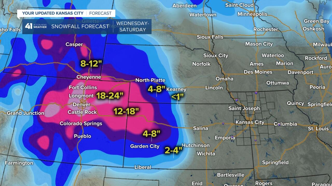
SNOWFALL FORECAST WEDNESDAY-SATURDAY:
Wow! One to 2 feet of snow is possible for Colorado into far western Kansas. Four to 8 inches of snow is possible as far east as Hays, Kansas, to Garden City, Kansas. It looks like the eastern extent of the snow will be from around Kearney, Nebraska, to west of Hutchinson, Kansas. This is about 150-250 miles west of Kansas City, Missouri. It can snow here in early May, but we will see all rain with this storm, close, but no cigar.
Have a great rest of your week and stay healthy.