

Good morning bloggers,
Snow spread up from the south early this morning and was tracking across I-70 at 3:30 AM. The roads immediately got covered again and it will be a slick morning commute here in Kansas City and surrounding communities. Temperatures did rise overnight and it was 6° as the snow began. This will be another fluffy-powdery texture and a quick 1/2" to 1" of snow is likely in KC. Kansas City has been missed by all the major snow storms around the nation. Our snowfall total for the season is just over 11 inches, and today will add just a little bit to this total.
3:10 AM Radar:

4:00 AM Radar:
By 4 AM the snow was crossing I-70 and moving into the northern metro area:

Radar is on high sensitivity mode to pick up the low moisture content in the snow. This pink to white area shows that it will accumulate quite quickly on all area roads. The road temperatures are so cold.

By 7:20 AM widespread slick and hazardous driving conditions worsened a bit! All the roads are snow packed. Look closely at this next radar image. The bright white area just southeast of Emporia, KS has a twist to it, and it is the main disturbance. It is moving northeast. There will likely be a band of slightly heavier snow as it passes, and then it will taper off to flurries.
Here are the road temperatures from earlier this morning:

The road temperatures are shown above, and the 3:30 AM air temperatures are below:

The record setting cold spell continues. One streak will break today. It is still below 15 degrees, and it has been 15 degrees or colder for ten consecutive days. This is the longest streak of 15° or lower ever recorded in Kansas City. There were 8 consecutive days in 1983. This streak will likely end at 10 days in a row. Even though it is snowing and cloudy, we are still expecting temperatures to rise to near 20° this afternoon. Here are some of the other records:
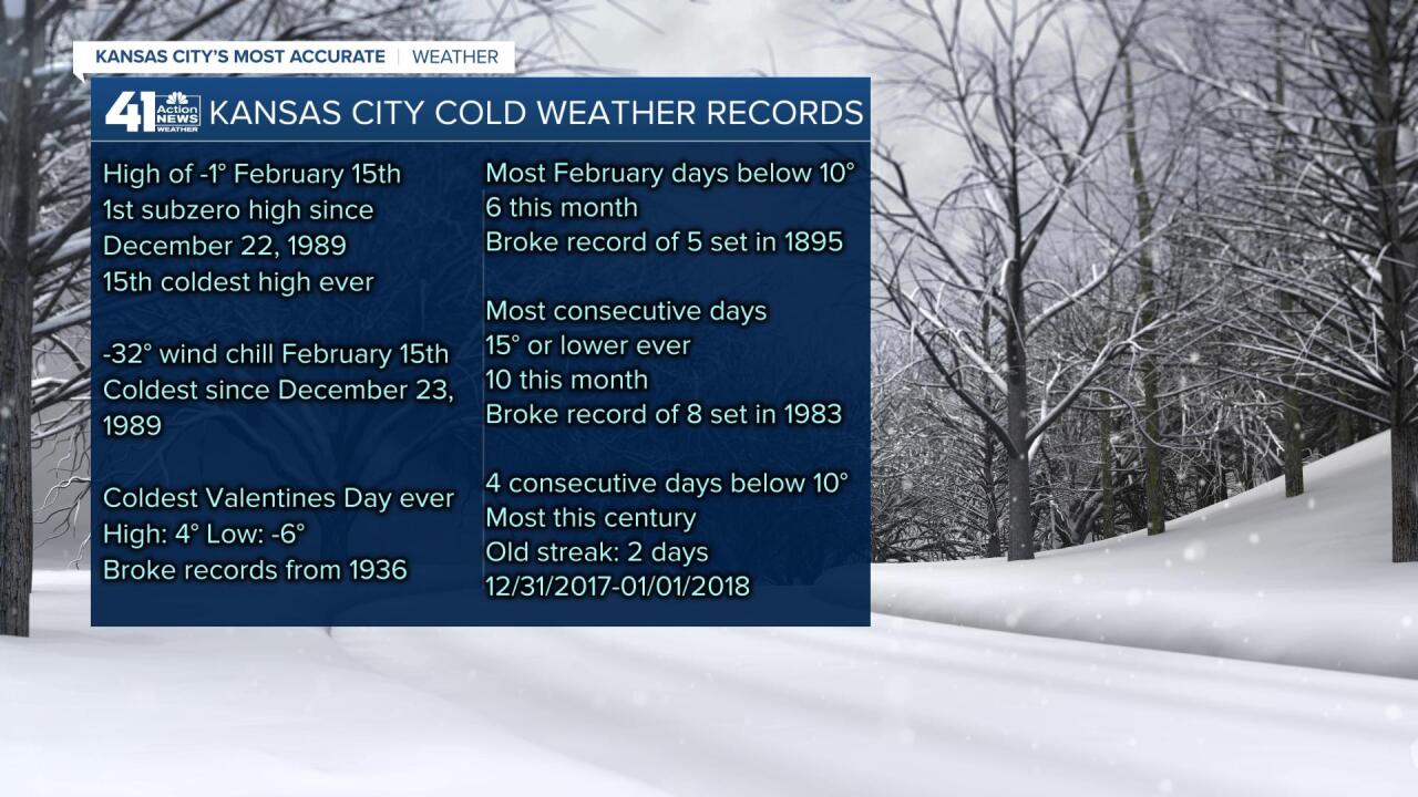
And, look at these records (thank you to Hugh Crowther for sharing this with us)

Kansas City Weather Time-Line:
- Now - Noon: Snow likely, and then tapering off to very light snow or flurries. Accumulations of a dusting to 1" expected. There will be a bit more to the south and east. High: 20°
- Noon - 6 PM: Very light snow or flurries with any additional accumulations very light. Wind chills: 5-10 degrees above zero.
- Tonight: Cloudy with a few flurries. A colder surge moves in and temperatures drop back into the single digits.
- Thursday: Some sun breaks out. Light winds. High: 21°
The warm up into the 40s and possibly 50s is still in our forecast for Monday-Tuesday. The Arctic air is retreating and warmer days are ahead of us. It was up to 8 degrees as I was finishing up this blog entry at 7:30 AM. Follow us on social media, my twitter handle is glezak. And my facebook page is GaryLezak.
Thank you for spending a few minutes of your day reading today's blog. Have a great day. Please provide yourself a lot of extra time today.
Gary
