

Good morning bloggers,
It's Friday! We made it through a 4-day storm system that began when rain spread in Monday, and then it ended yesterday afternoon with our last sprinkle. We had a soaking rain and some snow mixed in early Wednesday. Are we done with the snow for the season? Remember, it snowed April 17th and significantly last year. We have a few more storm systems lining up, and if we end up on the cold side, the winter part of the storm systems, then there will still be one or two more chances for snow.
We came into the week with a Red Flag Alert on Sunday. The rain wiped out any fire risk by Monday evening, and now we have too much soil moisture. Water is ponding all over the place. Look at the rainfall total for this month at KCI Airport:
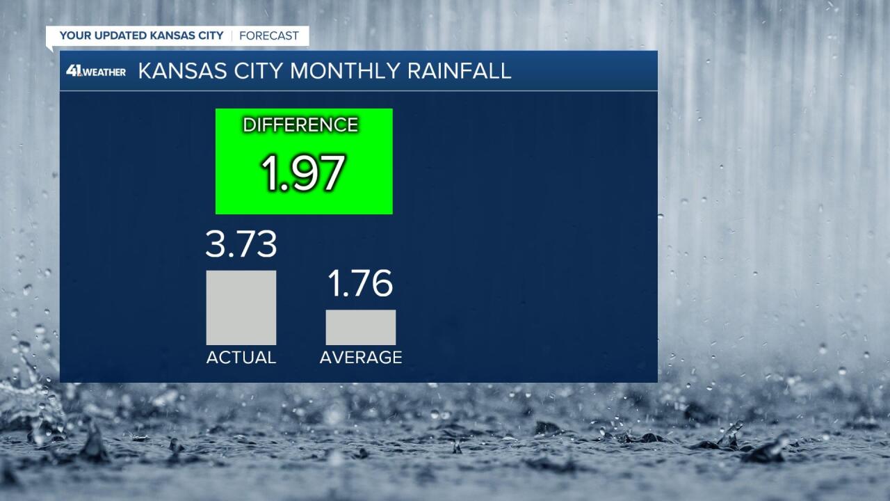
We had almost the entire months average this week, which added on to the totals from the earlier rain and snow storms this month. The March weather madness continues.

The weather pattern this week is now being influenced by that block I talked about in the last blog entry. The block is gaining strength and it is already showing influence on this weather pattern. It is really a complex thing to discuss, but let me try once again. Take a look at this next forecast upper level flow map valid on Monday:

The block can be seen by these upper high height centers over the far northern territories. There are two of them forming, and one of them you can see above. It is way up there north of Alaska. It is causing a colder air mass to shift south and the jet stream is energizing and the storm systems are being created a bit stronger by this blocking influence. A strong storm is forecast to move into California by Monday.
The Monday storm in California will produce some good, bad, and ugly influences for us. The first influence is the good. A big warm up is likely on Monday:

A warm front is likely going to remain dry and lift north of KC by Monday afternoon or evening. This will allow a big temperature jump into the 70s with the wind shifting to the south.
By Tuesday, the California storm will move closer and it will cause a strong surface low pressure area to form, as you can see below:

As this low pressure system strengthens, Gulf of Mexico air will surge in. This warm moist air will be monitored closely as it will be the fuel for thunderstorms next week. We will learn more about the timing and strength of this storm today!
We get to see the sunrise this morning, and it is a special day! Today is SUNNY THE WEATHER DOG'S 7th Birthday. Happy Birthday to Sunny. Here is a picture of her from when she was just 8 weeks old in 2015:

Thank you for sharing in this weather experience and spending a few minutes of your day reading the weather blog. Have a great day!
Gary
