

Good morning bloggers,
Would you be shocked if yet another warm up is on the way? It will likely jump back up into the 60s later in the week. What is going on?
The LRC is the centerpiece of a complex atmospheric puzzle. You can read more about the LRC in the winter forecast. Here is the link: There are other influences on the overall weather pattern, and three of them I know well. There is a weak and strengthening La Niña, the cooling of the tropical Pacific Ocean near the equator. And, there is a an influence from the Arctic Oscillation (AO) and North Atlantic Oscillation (NAO).

When there is a La Niña, we often see precipitation patterns that push the heavier amounts east of KC. This seems to be in play at the moment. I just think this will get balanced by the bigger picture later this winter and next spring with a few wet storm systems in our area.

A larger influence right now seems to be the AO & NAO. These indexes have drifted into positive territory. When they go positive, the jet stream energy gets spread out and shifts farther north. This has happened in the past week.
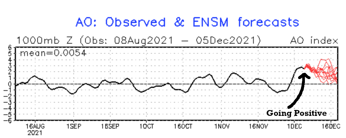

You can see the results of these positive indexes by looking at the river of air above us. One way to look at this is by analyzing the 500 mb level, which is around 18,000 feet above us. Look at the flow from just a couple of days ago when we reached a record high of 71 degrees:

This far north jet stream and the west to east flow around a broad Polar Vortex is allowing us to have another warm up later this week. Look at the flow by next Sunday for the Raiders/Chiefs game:

There is a storm system that is going to move over the west coast Friday and track over the central United States Friday night into Saturday. This storm system is caught in this AO+ and NAO+ influenced pattern. Last week, that storm was being modeled as a snow storm north of KC and then south of KC Friday into Saturday. So, we have to pay close attention to it. The models now have been trending as that storm being dry here. This system is now near Japan. The energy of this system is way out over the western Pacific Ocean, so let's see if there is a trend into a more functional storm. Either way, by Sunday, another warm up would begin. On last night's show, after the Chiefs FIFTH WIN IN A ROW over the Broncos game, I had 49° for the high next Sunday.
So, what does this all mean? For now, it means our dry spell will likely continue for another week or two:

We have now had no rain or snow for 21 days in a row. Today will make that streak reach 22 days in a row. The positive AO is likely the biggest reason why this next storm will likely miss Kansas City. When this part of the pattern cycled through in October, this next storm was quite wet. So, let's see if there is a trend back into a more functional storm around Saturday. For now, we are going with the trend towards the weaker storm; the faster moving storm; and likely more wind and no rain or snow.
Thank you for sharing in this weather experience and spending a few minutes of your day reading the weather blog. Have a great start to the week,
Gary
