

THE CHANCES OF RAIN WILL CONTINUE MOST OF THIS WEEK — Good morning bloggers,
We had some heavy thunderstorms over the weekend with close to 4" of rain in a few spots. Here are some of the official rainfall totals in the National Weather Service rain gauges:

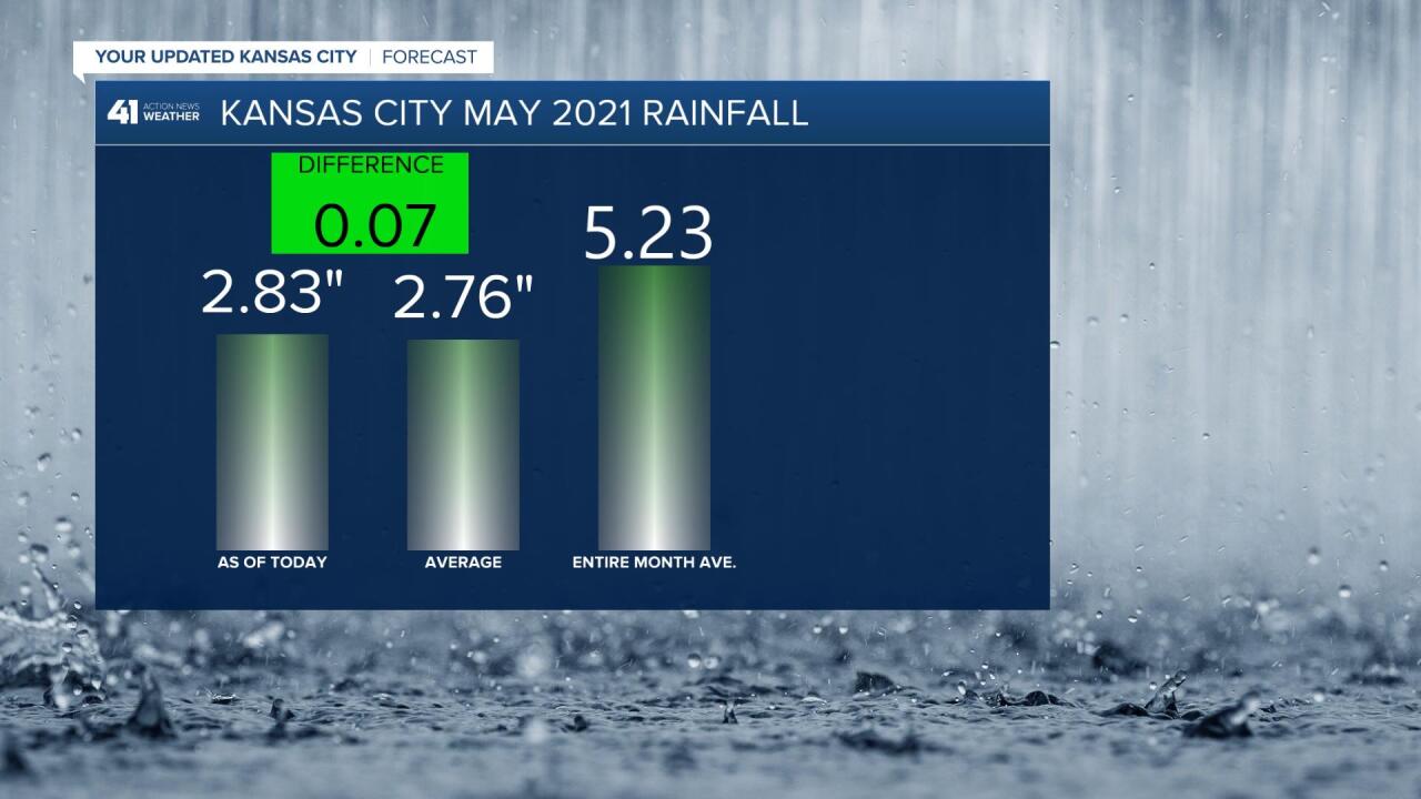
KCI Airport had just over an inch of rain, and this puts us up to near average so far this month. May averages 5.23" and more is on the way this week:
The weather pattern is going through a big transition this week, and by the weekend there is a good chance that an anticyclone will be developing over the southeastern part of the nation and it is forecast to drift west towards KC. This will likely provide the conditions for a big warming trend by the weekend. Let's take a look beginning with the pattern today:

This map, above, shows the flow aloft around 18,000 feet above us, or the 500 mb level. mb stands for milibar, which is a measure of pressure. The top of the atmosphere weighs 0 mb, or there is no weight as there is no atmosphere above the top, right? The pressure near the surface is close to 1,000 mb. So, the 500 mb level is around half way up in weight, and around 18,000 feet up. Atmospheric pressure measures the weight of the atmosphere above you. This map shows an upper level storm approaching us and it will weaken, stretch out, and pass us by Thursday. There is a wave of energy that will track overhead tomorrow which will likely produce a band of rain and thunderstorms.
Then, this next map below shows some interesting changes by Thursday. A storm will be dropping inland over the western United States. And, the opposite of a storm, or an anticyclone will be forming over Tennessee:

By Thursday, the upper level storm approaching us now will have stretched out and phased into the pattern. It eill leave this stream of disturbances that may produce some heavy thunderstorms Wednesday into Thursday. And, then there is that anticyclone that may move west. Take a look at what happens by Saturday on this American Model (GFS):

The upper level high, or anticyclone is forecast to drift west by the weekend. If this indeed does happen, then we are in for a warm and muggy weekend, and you can finally be thinking about getting out to the pool. If you remember well, then you will remember that many pools were closed last summer due to Covid-1`9. Well, most pools open around Memorial Day, which is not until the last day of this month, but we will at least have pool fever by the weekend, and some pools are opening.
Severe Weather Risk Today:
According to the LRC from our spring forecast in March, we predicted this week to be active, and this forecast is spot on. A moderate risk of severe weather exists today, and fortunately Kansas City is not in this risk. The tornado risk is significant in this moderate risk area over northwest Texas today:

Severe thunderstorms are forecast across portions of the southern plains later this afternoon and overnight. Very large hail and a few tornadoes will be concentrated across northwest Texas.
These risks keep going around Kansas City. We have still gone almost two full years without a tornado watch in the KC metro area. The last tornado watch was May 28, 2019. This is a good streak to keep going unless you are a storm chaser in our area!
Kansas City Weather Time-Line:
- Today: Cloudy with a misty light rain likely this morning. Just a little big of sun may come out with a chance of an afternoon downpour or thunderstorm. Chance of rain is 100% early this morning, then 40% this afternoon. High: 71°
- Tonight: Mostly cloudy with a slight chance of showers and thunderstorms. The chance of rain is 20%. Low: 63°
- Tuesday: Mostly cloudy with a few breaks of sunshine. A few showers and heavy thunderstorms are likely, especially later in the day. The chance of rain is 90%. High: 76°
- Outlook for next weekend: Sunny with a few clouds at times. Warmer with a south breeze at 5-15 mph. Highs in the lower 80s
Thank you for spending a few minutes of your day reading the Gabbing With Gary blog. Have a great start to the week.
Gary
