


KANSAS CITY, Mo. — Good Friday bloggers,
The last three days have been rather stormy across the southern, central Plains to the eastern USA. We use the LRC to track when the next chance a winter storm could affect our region. We ended up, officially, with one of the lowest snow totals for this large storm event. KCI received 2.3" bringing the season total to 7.6".
Here is a map of the current snow cover across the USA.

Here is a zoomed in version and you can see a slot of 1"-3" that was centered near Kansas City International Airport, the Kansas City official reporting station. There are higher totals about 50 miles east and west of our area. See Emporia, Kansas and Clinton, Missouri. Keep in mind this is current snow cover, not total snow. The snow has settled since it first accumulated.

When you zoom back out, we are 100 miles away from 6"-12" of snow. We were also 100 miles away from nothing, see northern Missouri.

Regardless of the low slot of snow, the snow cover is rather extensive to our west, east and south. So, a west wind today and gusty south wind on Saturday that would usually warm us up in to the 40s, 50s or 60s is going to be affected by the snow cover.
HIGHS FRIDAY:
It is colder to the north without much snow cover as colder air is moving in there. We are in a warmer slot due to a west wind, but the high is 30-35 instead of 40-45. Locations to the south and east where the snow cover is much deeper, highs are in the 20s. The snow is having a much bigger impact on high temperatures in those areas.

HIGHS SATURDAY:
The snow cover effect is much more pronounced. The wind tomorrow will be from the south-southwest at 15-30 mph. Locations to the west where most of the snow will have melted will see highs 55-60. Concordia, Kansas will see a high around 55, while Oklahoma City struggles to 40. St. Louis will struggle to get over 20! In other words, a cold south wind will be blowing across the Plains and Midwest. Since we are on the edge of the snow cover, we are on the edge of the "no snow cover" effect and "deep snow cover" effect areas. We should see highs climb to the low 40s. As the snow melts this affect will vanish by early next week.

Now, when is the next chance to add snow cover in the Plains and Midwest? When is our next chance of a winter storm? Let's use the LRC (Lezak's Recurring Cycle). Here is a brief refresher course on the LRC.
1. A unique weather pattern sets up every year in October (sometimes the end of September) and November and then begins cycling through the next winter, spring and summer.
2. There are locations where storm systems like to reach their peak strength (long term troughs). There are locations where storm systems are their most disorganized (long term ridges). We seem to be closer to the long term ridge as storm systems have struggled to reach their potential this season around here.
3. A cycle length is determined and this year seems to be 61-66 days long for an average of 63.5.
So, can we see this last storm on the pattern in the 61-66 day cycle range? See the maps below.
UPPER LEVEL FLOW (500 MB, 18,000 FEET) SATURDAY OCTOBER 2, 2021:
We have highlighted 6 features.
UPPER LEVEL FLOW (500 MB, 18,000 FEET) THURSDAY, FEBRUARY 3, 2022:
This is 124 days after October 2nd which is in our cycle range of 61-66 days. This is the end of the second cycle to start of the third cycle. 124 divided by 2 gives you 62.

We have highlighted 6 features here as well and will compare them to Oct. 2.
1. An upper level high in the eastern Pacific Ocean about 1,000 miles west of San Francisco
2. A small upper level low near San Francisco
3. A system in the southwest Plains near the Oklahoma and Texas panhandles; This is stronger in February as there is more jet stream energy in February as opposed to early October, 10 days out of summer.
4. A ridge in the Gulf of Mexico. In February it is pushed east to Florida as the stronger jet stream gives it a shove.
5. A big trough in the Gulf of Alaska with upper level waves breaking off and heading into western Canada and the Pacific Northwest.
6. A big upper low around Hudson's Bay, Canada. In February this is much bigger, like a Polar Vortex. Again, this is due to seasonal differences with a stronger February jet stream.
We call this a match. So, if we know the cycle length on Oct. 2, which at the time we do not, as the new pattern is just forming, we can project forward 61-66 days and give date ranges on when this storm will return. Once we know the cycle length we can make forecasts out all the way until the end of the following September.
December 3 is 62 days after Oct. 2 and the start of the 2nd cycle. The features were there in a skewed way as December, the first half of the second cycle, seemed to be anomalous. That was a very warm month and acted more like spring. There have been many years while using the LRC where we notice every other cycle is more similar. So, it will be interesting to see if LRC 2021-2022 is like that. The first indication that it is, will be if the next 30 days are 200-300% of average rainfall like Oct. 6 - Nov. 11. Or nearby it is that wet. Right now, there is no big sign of that, but things can change fast.
Let's project forward.
The next storm to track on the LRC is one that occurred Oct. 10-11. We received 2"-3" of rain and there was a lightning delay during the Bills vs. Chiefs regular season game.
Here is a 500 mb flow projection from the GFS (American model) from the 0Z run Thursday for Feb. 17. It is on the 330 hour map. 330 hours from 0Z Feb. 4. This is 64.5 days from Oct. 11.
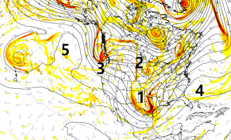
We have highlighted 5 features.
1. A storm in the southern Plains. In October it was near KC.
2. A smaller system in the northern Plains
3. A new storm system dropping southeast across the Pacific Northwest.
4. A ridge near the east coast.
5. A ridge in the eastern Pacific Ocean.
Let's look at the surface pattern which is dictated by what is going on at 500mb.
OCT. 11, 2021 SURFACE:
There was a mid-latitude cyclone, or deep low pressure area in southeast Kansas. KC was in the comma head of the storm and that is why we had so much rain.

Here is the 330 hour American model projection from the 0Z Feb. 4 run of data. It is very similar, but a state farther south. This would miss KC.

We look at this as a match from Oct. 11 to Feb. 17. Since, we know the cycle and we know what occurred Oct. 10-11 and we see signs of "every other cycle," we can make a forecast projection.
2 WEEK FORECAST:
The next chance we have of seeing a winter storm is around Feb. 17 give or take 1-2 days. This DOES NOT MEAN WE WILL HAVE A WINTER STORM. It is just our next chance. As is, on this data it would mostly miss us to the south. Since Nov. 10th we have been either missing or being on the edge of all storm systems. It will be interesting to see how this evolves the next several days.
Have a great weekend and stay healthy.
