


Good Tuesday bloggers,
We have really dried out after four to five weeks of well-below average rainfall, especially south of Interstate 70. Some locations had the driest April in over 20 years!
Overland Park to Olathe to Pleasant Hill to Sedalia have seen amounts around 1" or less rainfall in April to name a few locations. The average is 4.05" of rain.

The map below are rainfall totals from the last 30 days as estimated by radar. So, your rain gauges may read different. You can see even in locations that had rain, such as northeast Kansas, were still .50" to 1" below average.

Due to the lack of rainfall, the drought we got rid of over the winter is creeping back in from the west where the drought has been persistent and intense.

A closer look shows a level 1 and 2 of 5 drought extending northeast from southeast Kansas to northeast Missouri. Nevada, Clinton, Sedalia to Columbia, Missouri, are in a level 2 of 5 drought with a small level 3 east of Columbia. A level 1 of 5 is into the south side of Kansas City.
The next Drought Monitor comes out Thursday and will not count the ongoing rain. So, the drought will likely look worse before it gets better.

So, needless to say, we need rain. And the first chance of rain arrives Thursday. This will be the start of an active weather pattern.
Below is the upper level flow from Monday. The jet stream is in the shape of the Greek letter Omega. These can last several days to weeks. When you are in or east of the ridge, the middle part, you get dry weather. That is where we have been the last two to three days and will be there today into Wednesday.
This block is not the only reason why we have been so dry the last four to five weeks. It is just part of it. We have been missed or received the minimum amount of rain from systems the last four to five weeks along with some other dry stretches.

By Thursday and Friday you can see the Omega block is breaking down and the flow gets odd across the USA. The big Great Lakes storm is east of New England, there is another upper level low in the northern Plains that is drifting west. A big storm on the west coast, making up the west end of the Omega block will begin to head east. As it does, it is going to kick a smaller system out into the Plains Thursday and Friday, If you look closely, there is a little kink in the flow near KC.
BTW, the storm in the western USA, is going to bring a rare May 1-2 feet of snow in the Sierra Nevada mountains.

The little storm system that will be in our area Thursday-Friday is located east of Hawaii today. This system will combine with a front and increasing Gulf of Mexico moisture. This should bring our area a widespread rain event. Let's go through this first chance of decent rain in weeks.

TODAY:
It will be dry, sunny and breezy with highs in the mid 60s. The wind will be from the northwest at 10-20 mph which is not as strong as we saw Sunday, Monday and Saturday evening. But, it is strong enough along with low humidity and the dry ground to create an elevated fire danger. This means fires can start faster and any fires that do start can spread fast.

WEDNESDAY:
It will be another sunny and dry day, but there will be much less wind with highs in the low 70s. This will make for near perfect Wednesday weather.

THURSDAY MORNING:
We will be tracking a cluster of showers and thunderstorms along a newly formed front in the southern Plains. This cluster may stay south of our area, but it is not set yet.

THURSDAY AFTERNOON AND NIGHT:
A few showers and thunderstorms are possible during the afternoon with highs in the 60s. Then, the system now east of Hawaii will combine with the front. This will create a zone of widespread and at times heavy rain and thunderstorms. The severe threat is rather low as the flow aloft is weak.

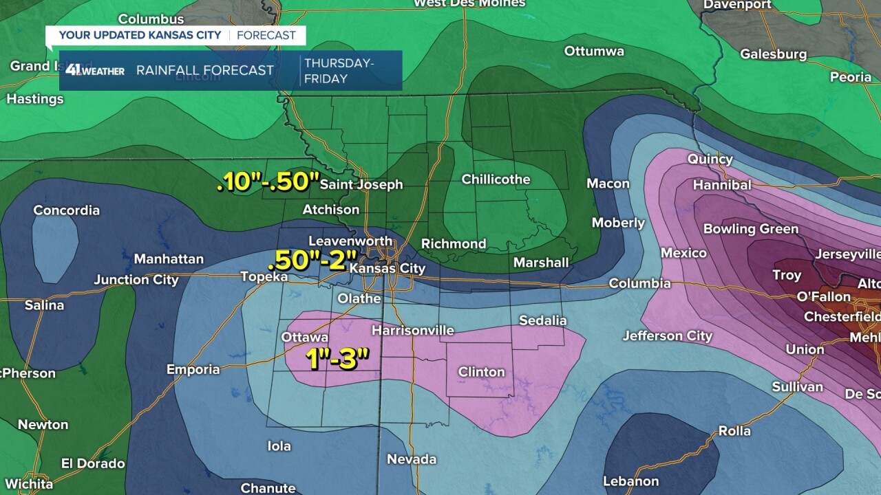
RAINFALL FORECAST THURSDAY-FRIDAY:
We are confident that a zone of heavy rain and thunderstorms will set up in the area. There is still some uncertainty on exactly where it will set up.
Right now it looks like the heaviest where 1"-3" of rain could fall will be south of I-70. And as you saw above, this is where it is needed the most. This zone could still shift north or south by 50-100 miles.

A closer look shows that all locations will see rain. If you do not get the rain you need, there will be more chances next week. Some of the chances next week may have a higher severe weather potential as it will become warmer with highs around 80° and much more humid.
Have a great week and stay healthy.
