


Good Sunday bloggers,
Super Bowl week has begun. Let's enjoy it as being in three Super Bowls in four years is a rare event. I am old enough to remember the 50 years in between Super Bowls.
If you are headed to Glendale, AZ it will be mostly nice this week with highs in the 60s and 70s. But, Super Bowl weekend will likely be cool, highs in the 50s, with a chance of rain showers. The stadium has a retractable roof, so it will be dry for the game.
What about the weather for Super Bowl week in Kansas City? We will be tracking two storm systems after two days of unseasonably warm weather.
Before we get to the big week ahead. Let's look at our fall/winter season so far. It has been an interesting one.
TEMPERATURES OCT. 1-FEB. 4:
It has been warmer than average with January being the most above average. November and December were near average, but no month has been below average. The December average was brought down by the intense Arctic outbreak Dec. 22-25.

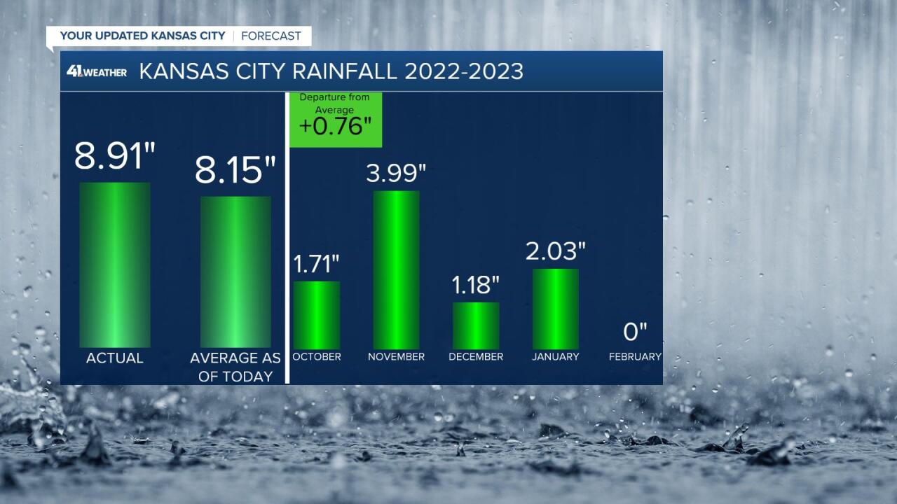
RAINFALL OCT. 1-FEB. 4:
We have seen nearly 9" of rain. Locations south of I-70 have seen 10-11" of rain. November was the wettest month. Keep in mind, we do not average much rain during the winter. We are running about 101% of average since Oct. 1. This has been much needed as we have pretty much ended the drought. There are still levels 1, 2 of 5 drought in the area.
SNOWFALL OCT. 1-FEB. 4:
We have seen just 4.7" of snow, with 11.1" being average as of February 4th. This is where it gets interesting. So, we have seen almost 9" of rain since Oct. 1 and just 4.7" of snow. If one half of the rain fell as snow, we would have nearly 45" of snow. Let's say 2" of the 9" of rain fell as snow. That is nearly 20" of snow.
What is going on? Well, we have seen our bigger storm systems when it has been too warm for snow. This is not unusual for October and November. But, it is quite rare for this to happen consistently in December and January.

In summary we have been wetter than average since Oct. 1, but way below average on snowfall.

Here we are in February. Will we break the trend? Let's take a look at the two storm systems for this week.
TODAY:
No storm systems today as we will see abundant sunshine and a light wind with highs around 60°. This will bring the February temperature average way up. The average high for today is 41°.

MONDAY:
The average temperature for February will soar again as highs climb to 60°-65°. It will be rather windy with south winds gusting 30-40 mph. There will also be lots of clouds. Rain showers and a few thunderstorms are possible Monday night along I-44.

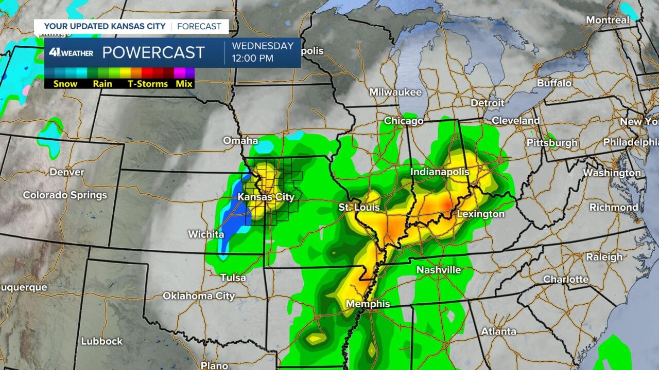
WEDNESDAY (STORM SYSTEM #1):
Tuesday will be a nice day with highs in the 40s. The first storm system will affect our area on Wednesday, unless it tracks too far south and east.
If we get the storm, we would likely be in the comma head. This is where the most consistent and heavy precipitation occurs. During the winter this is almost always snow. This winter we have been in comma heads of storm systems, but they have been mostly rain.
The data is in agreement that if we get into the comma head it will struggle to produce snow as again it is too warm. It would not take much to be snow. We will watch it.
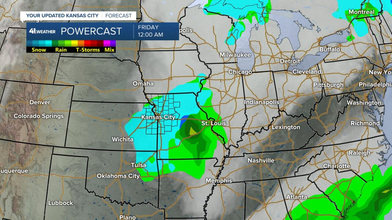
THURSDAY-FRIDAY (STORM SYSTEM #2):
The second storm system is timed for Thursday night-Friday. If we are going to see accumulating snow this week, it will be most likely with this storm system. It will be cold enough for snow with this one. But, there are still many questions on the track of this storm. Regardless of what happens, the second system will be long gone by Super Bowl Sunday. Highs may reach 50° on the big day.
Have a great week ahead.
Stay healthy
GO CHIEFS!
