


Good Monday bloggers,
It is hard to believe Christmas is one week away. The weather pattern is unusual to say the least. We are tracking a series of storm systems with unseasonably warm air. This means our chance of a "white Christmas" is approaching zero. What about other locations across the USA? It takes 1" of snow on the ground on Christmas Day to be considered a "white Christmas."
Let's go through this.
TODAY:
Highs will be around 40° with a northwest wind 10-20 mph. This brings wind chill values down to the teens and 20s. The average high is 42° and the average low is 23°. This looks like the coldest day of Christmas week.

The upper level pattern between today and Christmas day is becoming a split flow. This means the jet stream splits into a northern branch and southern branch. The northern branch will hold the Arctic air to far northern Canada to the other side of the world in Siberia as it will be located way north in Canada.
The southern branch delivers storm systems and it will bring an active weather pattern to the USA. You can get snow this time of year without Arctic air. However, there will not just be a lack of Arctic air, but a lack of cold enough air for snow. This issue is not just confined to our area and south.

TUESDAY-WEDNESDAY:
These will be dry days across the Plains and Midwest as we await the first storm system in the southern branch to approach. Highs will rise to near 50° Tuesday and near 60° Wednesday.
THURSDAY:
The first system moves in on the southern branch and will bring rain later Thursday into Friday to locations along and east of Interstate 35. It will be raining north to Wisconsin.

SATURDAY:
There may be some rain Saturday but the next system will affect Christmas eve and day.
CHRISTMAS EVE:
Rain will move in from the south and actually it will be raining all the way to Rapid City, South Dakota, and Minneapolis. The only snow will be in the mountains of the western USA.

CHRISTMAS DAY:
This is odd for sure as it will be raining not just to the Dakotas and Minnesota, but all the way into southern Canada. The nearest snow is around Hudson's bay!

SNOW DEPTH FORECAST CHRISTMAS DAY:
It takes 1" or more of snow on the ground for it to be an official "White Christmas." The areas that have the chance of 1" or more of snow on the ground is North Dakota and the mountains of the west. Even southern Canada has little snow. This is most unusual.

RAINFALL FORECAST TODAY-CHRISTMAS DAY:
The lack of snow is not due to a lack of precipitation. It's so warm that the precipitation across most of the USA will be rain.
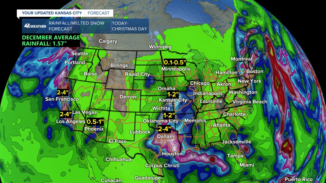
December is one of our driest months on average as colder air holds less moisture. But, when it is warm like this, we can get heavier precipitation.
We may see 1"-2" of rain between Thursday and Christmas day. December averages 1.57" and we have already seen 1.22" of rain this month. So December may end up 200% of average. This is not a bad thing as drought conditions remain in most locations.

The reason for the rain and not snow is that Thursday through Christmas day will see highs 55°-60° with lows 45°-50°. One or two days may see lows in the 50s.
When we look at the forecast for December 21-25 the record highs are 63°, 67°, 67°, 72° and 67° respectively. Clouds and rain will keep us away from record high temperatures.
But, the clouds and high moisture content of the air from the Gulf of Mexico may allow us to come close or break record high low temperatures. Remember at night, clouds act like a blanket.
Below is a table of the record high low temperatures and our forecast for Dec. 21-25. One of these days may see lows break the record.

So, the chance of a "White Christmas" is near zero, but the chance of a "foggy Christmas eve" is much higher.
Have a great week
Stay healthy
