


Good Wednesday, bloggers —
We are continuing to track the potential to see the hottest day of 2024 so far and the potential to see severe thunderstorms.
Let's go through this.
TODAY:
If it reaches 90° at KCI, then we will have our first 90° high, officially, since Oct. 2. A south-southwest breeze will help a bit.

THURSDAY AFTERNOON:
If we don't reach 90° Wednesday, we will on Thursday. Downtown may climb to 97°.
The humidity will get out of control as dewpoints reach the mid and upper 70s. This will create heat index values between 100° and 105°.
A cold front will be entering northern sections of Missouri and Kansas by 5 p.m. The front will interact with the heat and humidity and create thunderstorms.
Some of the thunderstorms may be severe.

We are in a level 2 of 5 severe threat for Thursday evening and night. The main threats are damaging wind and hail.
Wind is severe when it is 58 mph or higher. Hail is severe when it is 1" in diameter or larger.


THURSDAY EVENING/NIGHT:
A solid line or broken line of thunderstorms will affect our area between 5 p.m. and midnight Thursday. Some may be severe.
Locations that get the thunderstorms could see a quick 1"-2" of rain. Other locations may not see a drop.

FRIDAY:
The front will be hanging in the area. So, northern Missouri may get a brief reprieve from the high humidity.
Otherwise, it will be another humid day with highs in the 80s. There will be a chance to see a few showers and thunderstorms.

FRIDAY NIGHT-SATURDAY MORNING:
A system will track out of the Rockies, creating a huge cluster of thunderstorms in Nebraska.
This cluster will track northeast, but there may be a south extension of thunderstorms to our area along the front that is becoming a warm front.
Some of these thunderstorms could produce damaging wind and hail as well.
We are in a level 1 of 5 severe threat with the higher threat to the northwest.

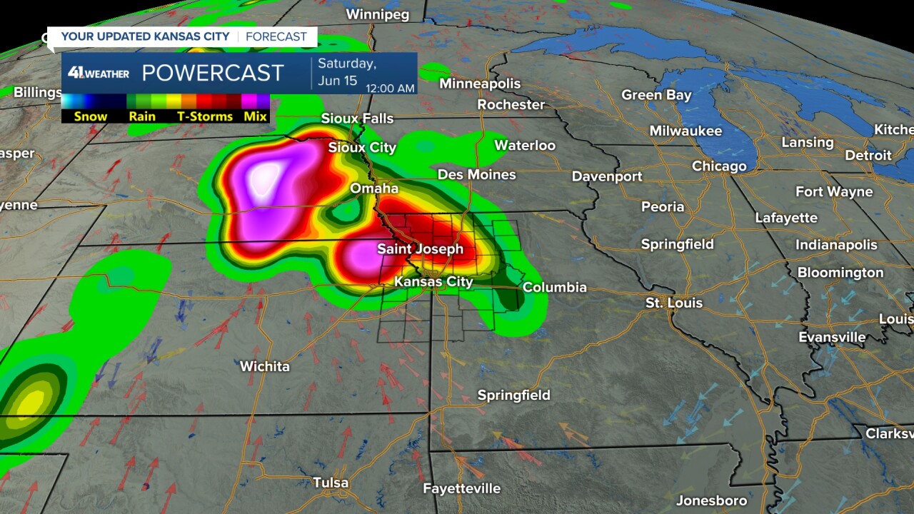
SATURDAY MORNING:
The thunderstorms will be moving away into Iowa and eastern Missouri. The front that was here is lifting north as a warm front and falling apart.

SATURDAY AFTERNOON/EVENING:
An isolated shower or thunderstorm is possible with highs 85°-90° along with high humidity. A south breeze at 10-25 mph will help some.
The main area to watch will be eastern Nebraska to western Kansas. A broken line of thunderstorms, some severe, will form out there.

FATHER'S DAY MORNING:
The thunderstorms that form out west will head east and most likely fall apart, or move in much weaker.
The humidity will be plentiful, so there is a chance the thunderstorms don't fall apart as fast.

FATHER'S DAY AFTERNOON:
Whether we see thunderstorms or not, it will remain very humid with highs near 90°. A front will be stalled along I-80.

This front will waver north and south next week creating thunderstorms. So, next week we will see highs mostly around 90° and lows around 70° with a chance of thunderstorms every 2-3 days.
The front is most likely nearest to our area Wednesday.
Yesterday, we talked about the potential of added rain from a tropical system in the Gulf of Mexico. The system will be weak and it may add enough moisture so that we have more cumulus clouds, which will keep us at or below 90°.
The trade-off is that the humidity will be sky-high. The only heat and humidity relief would be if the front to the north can slip through.
If it does, it will be a 1-day heat and humidity reprieve.
WEATHER FORECAST SUMMARY WEDNESDAY-FRIDAY:
A breeze will help some today and Thursday. But Thursday will see out-of-control humidity.

YANKEES VS.ROYALS:
The weather for tonight's game will be nice. The weather for Thursday's 1:10 p.m. game will be hot and very humid. A south-southwest breeze at 15-25 mph will help a bit.
Now, pitchers beware Thursday as the heat and humidity will make the ball carry as there is more water vapor in the air.
Water is lighter than air and hot air is less dense, so you have a carrying ball with a 15-25 mph wind blowing out to center and left field. Again, pitchers beware.
Yesterday, I said I would be happy if the Royals could win 2, now I will be happy if they can win 1 of the next 2. The Yankees are one heck of a good team.

Have a great week.
Stay healthy.
—
