


Good morning bloggers,
The pattern continues to cycle according to the LRC. The new pattern is still a few weeks away from developing. For now, we continue to experience the same pattern that set up last fall. Other parts of the nation have been blasted by major storm systems, the latest of which was Major Hurricane Disaster Ida. The clean up and support from communities all over the USA continues from Louisiana to New Jersey & New York. The biggest disaster in the northeast came from people that lived in "basement homes", where people lived in basements and had no escape when historic flooding happened in a flash flood and people were drowned. That disaster clean up effort continues. The tropics are still active and there is a hurricane over the Atlantic Ocean, Major Hurricane Larry. Larry will begin weakening today as it goes over cooler water and turns north.

There is another disturbance in the southern Gulf of Mexico, but we are not expecting this one to develop. It is also on schedule per the LRC prediction from last spring. It is the one following this that needs to be watched even more closely.

There is a cold front sweeping across the northern plains early this morning, and by 1 PM this afternoon it will be just northwest of KC. Temperatures will warm up to near 90 degrees ahead of this front, and then cooler air will move in later this afternoon and evening. Temperature will drop into the 50s by morning in the KC region. There is a 20% chance of showers and thunderstorms ahead of this front, but that chance is triggered after it passes KC. The chance increases just south and east of our viewing area later this evening, so we are expecting this front to pass through our region dry.
So, this front will move through today, but will the weekend front pass through KC? Take a look at the weekend cold front below:

The models are all over the place on the weekend cold front. Some of them stall it north of KC, which would have our temperatures near 90 degrees for the Chiefs game. Other models bring the front through, but stall it, and this would mean lower to middle 80s. Either way, it is looking dry for the game.
On the map above, another tropical disturbance is likely going to be forming near the Mexico east coast later this weekend. This disturbance lingers for around a week and it will likely produce excessive rain in Louisiana and Texas in the next two weeks. Will it form into a named storm? Our LRC analytics have this one as a strong candidate for a named storm near Louisiana again around the 20th.
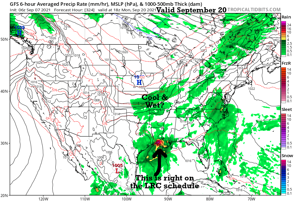
We will be monitoring all of these things. As usual, the weather around KC is not as exciting as other parts of the USA in this pattern we have been experiencing, but it is far from boring. Let's see how these developments come together.
Kansas City Weather Time-Line:
- Today: Mostly sunny, hot, & humid. A few afternoon clouds and the wind shifting to the north by later this afternoon. High: 88°
- Tonight: Clear and cooler. Lows dropping into the 50s by morning. Open up the windows!
- Wednesday: Mostly sunny and gorgeous. Light winds. High: 81°
- Thursday: Mostly sunny. Lows in the 50s and highs in the lower 80s.
- Outlook for Sunday: Mostly sunny with temperatures in the 80s.
New data will be rolling in soon and we will update this forecast.
Thank you for spending a few minutes of your day reading today's blog. We will be getting new data and updating the trend on the forecast on our newscasts today and tonight on KSHB-41 News. Have a great day.
Gary
