


Twas the day after Christmas, when all through KC,
Not a creature was stirring, except for employees at KSHB.
The snow shovels hung by the garage door with care,
In hopes that some snow soon would be there.
Good Tuesday morning blog readers —
Snow is wrapping its way into the forecast today. While this will be a low-end snow event for us, we should see some accumulating snow.
It will arrive in weak bands that will bring trace snow for some but up to two inches for others.
We are tracking a system that's bringing major impacts to our neighbors in Nebraska and through the Dakotas.
For us in Kansas City, expect limited impacts and the main focus to be accumulating snow Tuesday into Wednesday.

Snow timeline
Tuesday morning — light flurries and light snow showers are possible, but don't expect impacts through the Tuesday morning commute.
Many will be shocked by how cold that morning air is with wind chills in the 20s.

Tuesday afternoon — snow will start to wrap in with some bands bringing moderate snow rates. We could see a trace to one inch start to stick on grassy areas. Brisk winds are expected to keep wind chills below freezing.

Tuesday night — snow showers persist but remain light with cold breezy conditions holding as well.
Wednesday — Light snow showers begin to taper as our system begins to move out.

Snow totals land in the trace to 2-inch range. The key here will be to watch where the bands develop; these won't be big snow bands by any means, but they will boost some totals in those areas.

Goodbye 2023 and hello 2024
When it comes to snow, we are behind a bit. U.S. snowpack is lagging at under 30% of normal for this time of year.

Here in Kansas City, we are a bit behind as well. Normally, by Dec. 25, we see 4.5 inches of snow. This year, thanks to one snow event after Thanksgiving, we are sitting at 2.2 inches.
This time last year, we were further behind, and in 2021, we hadn't seen measurable snow.
Keep in mind, in order to technically register as a white Christmas, we need at least 1 inch of snow.
So tomorrow, will we register as a white 'day after?' Some certainly could, and that could bring us back to near-normal for snow this year.

Our El Niño pattern is starting to come alive in January, so does that mean a pattern change is likely to come in with 2024? The CPC has published its January outlook and it screams El Niño.
The northern tier of the U.S. will trend warm with the West Coast and southeast trending wet.


But there isn't a clear signal here in Kansas City for the month of January. We are expected to hold in a strong El Niño for the winter month but transition to neutral into the spring.
Well, let's look beyond ENSO at another key metric that governs a lot of our weather this time of year — the polar vortex.
So far our polar vortex has been weaker compared to average. The CPC forecast favors the polar vortex to remain slightly weaker than normal.
What does that all mean for us? Well, a stable polar vortex keeps cold air north, but a disrupted or weaker polar vortex allows for wiggles that plunge cold air south into the Plains.
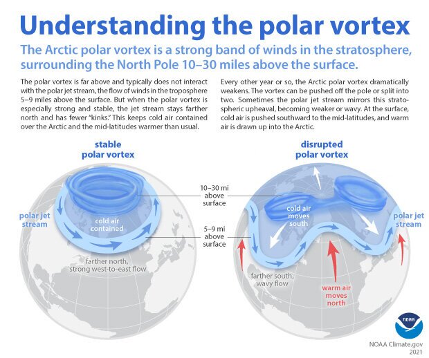
If the polar vortex remains weak, especially for a prolonged period, additional small wobbles can create more dysfunction and could even break it down completely.
So some change, but still a lot of mud in our cold air forecast for the winter. So I understand why the CPC is holding KC in the no-mans-land of zero-trend for January.
This doesn't mean we won't see cold weather or snowy weather, just that there isn't a strong climate signal to indicate one way or the other, so our day-to-day forecast trends will be vital as we move through the month.
—
