


Good morning bloggers,
The tropics have been very quiet over the Atlantic Basin. This may be a huge surprise for most of the sources that attempt to make tropical predictions. Take a look at the predictions made for this season months ago from all of these company's and government agencies:

ACE stands for Accumulated Cyclone Energy, and so far this season the ACE score is sitting at 2.8. Normally by Aug. 10 the ACE score is 13. This means that hurricane season is currently at around 22% of the average hurricane season.
As you can see on the chart above, every other forecast is for the ACE to be above to way above average, or a very active hurricane season in in the predictions from these other companies and government agencies.
Weather 20/20, using the LRC, made a prediction that the Atlantic basin would have a quieter than average season with a near to below average ACE score. This prediction was published in a press release we put out last March. As many of you who have been following our predictions in the past few years, the LRC has helped Weather 20/20 predict, not just the overall hurricane season accurately, but even more importantly we have predicted when and where named storms will track and make landfall and months ahead. Using the LRC we have shown that the next hurricane season actually begins in the fall when the LRC sets up. It then goes dormant, and then wakes up in May and June. This year, it is still sleeping.
Peak hurricane season is still a month from today, so there is a lot of time for it to become more active that it has. We have now gone 39-days in a row without a named storm and there is a disturbance over the Atlantic that is struggling to form. It is somewhat active over the Pacific Ocean, but very quiet over the Atlantic basin as you can see on these next two satellite pictures.

It has been somewhat active over the Pacific north or the ITCZ (Intertropical Convergence Zone). Hurricane Howard has just weakened to a tropical storm west of Mexico and it is weakening.
Over the Atlantic, on the other hand, it has been extremely quiet:

Peak hurricane season is still one month away. The LRC prediction of a quieter season certainly seems as if it will verify in the next few weeks as it looks like we will go another two weeks or so before anything forms.
We do have one big target, also predicted five-months ago. We will be monitoring the area between Florida and Cuba as we approach the end of the month. There have been three named tropical storms so far this season in the Atlantic Basin.
- Tropical Storm Alex: Alex actually came from a disturbance over the Pacific Ocean. It then crossed Central America and moved over the warm Gulf of Mexico water and didn't organize until after it crossed into the Atlantic
- Tropical Storm Bonnie: Bonnie formed just as it was moving into Central America from the Caribbean Sea. It actually crossed into the Pacific and became a hurricane
- Tropical Storm Colin: This system was alive for less than one day and was named while it was actually inland. Once it moved out over the Atlantic it fell apart
The next named storm will be "Danielle." What is the reason for the quiet beginning to the hurricane season over the Atlantic Basin? The LRC! The LRC describes the order in what most meteorologists think is chaos. Let's see how the rest of the season goes. Expect it to finally to wake up a bit around two to three weeks from now!
As the tropics remain quiet, Kansas City's weather has been drying out, as discussed in yesterday's blog. This dry spell will continue for a few more days.

Temperatures will be heating up this weekend. A weak surface cyclone is forecast to develop over the northern plains by Saturday. This will actually help bring the hotter air in here.

By Sunday, the system tracks into Iowa and conditions appear to be very favorable for a surge to near 100 degrees. It will become very hot with increasing humidity.
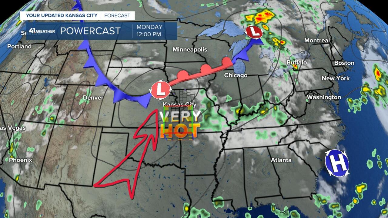
By Monday, the system will begin redeveloping near the Kansas/Nebraska border, and then by Tuesday, below, you can see a set-up for heavy rain and thunderstorms:

Most of the models are showing our rain chances as fairly low. It is getting very dry, and with some heat building in this weekend we will really need a drink of water. As discussed yesterday, we are in the part of the pattern, the part of the LRC that produced a long dry spell last fall. We will see how the new data comes in today, but for now it is going to be dry for a few more days at least.
Here comes the heat:

Some of the models are showing that the "heat wave creating machine" will be growing over the plains again. This map above shows 101° in KC Saturday and even hotter on Sunday. We will update our forecast later today if this trend continues. This appears that it will be our third heat wave of the summer.
Thank you sharing in this weather experience and spending a few minutes of your day reading the weather blog.
Have a great Wednesday. It's a gorgeous start to a great summer day!
Gary
