


Good Monday, also first day of spring, bloggers,
Highs were in the 20s Saturday, 40s Sunday, so if the pattern continues we should see highs in the 60s today. And, yes, that is the case. Spring begins at 4:24 p.m. and we will see highs in the low 60s. It will be mostly sunny, but a bit on the windy side. Today is the easiest forecast of the week as we will be tracking a series of storm systems and a slow moving front.
Let's go through this.
TODAY:
Highs will reach 60°-65° with south-southwest winds gusting 35-45 mph. There is a front along I-80 with Arctic air to its north. This front will slowly work its way south towards I-70 the next two to three days.

TUESDAY:
We are going to drop around 10 degrees without a cold front. This will be due to clouds and rain as a new warm front forms in central Kansas. 70s and 80s will be around 150 miles to our west. The warm front to the west and cold front from the north are going to make for a tough temperature forecast Wednesday and Thursday.

There is a 100% chance for our first spring rain Tuesday morning. The rain will end by noon.

Tuesday afternoon will be cloudy and breezy with temperatures 45°-50°. A few showers are possible with southeast winds 10-20 mph.

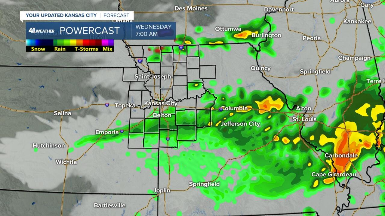
WEDNESDAY:
The high temperature forecast will be tricky as we will be tracking the location of a frontal boundary. You can see on Wednesday that we are in the cooler air, on this data, with temperatures in the 40s and 50s. 70s and 80s are about 100 miles south. There are some data that have us around 70°. So, this forecast is highly subject to change. At this moment, we are going for a high of 68° on Wednesday. The high could be 48°, 58° or 68°, this is March in KC.

The front will for sure be in the area and there will be a series of disturbances running along the front. This will generate areas of rain and thunderstorms Wednesday and Thursday. The heaviest rain will occur near the front.
Tomorrow night the potential is there for an area of heavy thunderstorms along the front. Since this data has the front to our south, this is where the bigger thunderstorms are located.

Other area of showers and some thunderstorms will be around Wednesday morning and then again Wednesday night into Thursday. The location of the heaviest rain and thunderstorms will be found where the front is located.
RAINFALL FORECAST TUESDAY-FRIDAY:
Regardless of where the front is located, it looks like the main rain and thunderstorms will get their act together along I-44 when the front gets there. It also looks like the part of the front across central and western Kansas will have little to no rain where they really need it. We are in the most wishy washy area as the rain and thunderstorms will be getting their act together in our area.

This is the drought monitor from March 14th. The drought in our area has been eliminated as we have seen plenty of rain since October. But, did you know that just 120 miles to the southwest there is an exceptional drought? It is really amazing the change in such a short distance. When you see the drought monitor and then see the rainfall forecast above, you can see why the drought situation is the way it is. It has been this way since October.

Here is the forecast summary for today and tomorrow. Yes, these are the two easier days to forecast.
Spring begins today and it will be mostly sunny, windy and warmer. Winds may gust to 40-45 mph from the south and southwest.

There is a 100% chance of rain Tuesday morning. Be prepared for a wet morning rush hour. The high of 50° will likely occur around midnight. The wind will be southeast at 10-20 mph.

Have a great week ahead and stay healthy.
