

Good Thursday blog readers —
In corner one we've got winter, and in corner number two, we've got spring.
The bell will ring this weekend and then the fight will begin!
Here's a look at our headline fight and what to expect in the center of the ring (or center of the country aka here).
There is still a good amount of uncertainty where that mixed line will be and where the severe storms will be.
But the bulk of the snow will stay north of us and the bulk of the severe weather will be south of us.

Our main impact will be rain and some thunder, with heavy snow possible from Denver to Minneapolis, and severe storms from Dallas to Wichita Sunday night, and St. Louis south through the gulf coast by Monday night.
Spring system
Sunday
The warm branch of this system will impact Kansas City mainly starting Sunday. Although, we could see some passing showers leading up to Sunday.
But when it comes to steady precipitation, we are forecasting a rainy day with some thunderstorm development possible late Sunday night as the warm front moves through.


The main concern for severe weather Sunday night stays through central Kansas. We will watch a line of storms develop and charge toward Kansas City.
Right now, it is looking more likely to see storms here after midnight. With that expect them to be on their last leg.
Right now the Storm Prediction Center (SPC) has highlighted a level two risk for areas near Wichita south into north Texas.
This could mean we could see a level one risk introduced for the Kansas side of our viewing area.
But the main threat will be gusty winds with a collapsing line of thunderstorms for us as we head through the night. Be prepared for a groggy Monday morning if you have young kids or dogs who don't like stormy weather.

Monday
As the cold front approaches, we will see lingering moisture and storm chances move through the area Monday morning.
But this will also be a refueling moment for the main system.

As the cold front lifts gulf moisture into the plains, another round of severe weather is likely to fire into Monday evening.
By this time though, the cold front should be well past us with severe storms more likely for areas like St. Louis and Nashville and south along the Mississippi River.
The SPC has already issued level two risk for severe weather five days out. We may see a level one risk for areas closer to the Ozarks on the Missouri side as storms reignite through Monday, so stay tuned.


Right now, I think the biggest impact we will see in the Kansas City area from this system will be soaking rains with two to four inches possible as we head Sunday into Monday.
Winter system
The northern part of this system will bring snow to a snow starved portion of the country.
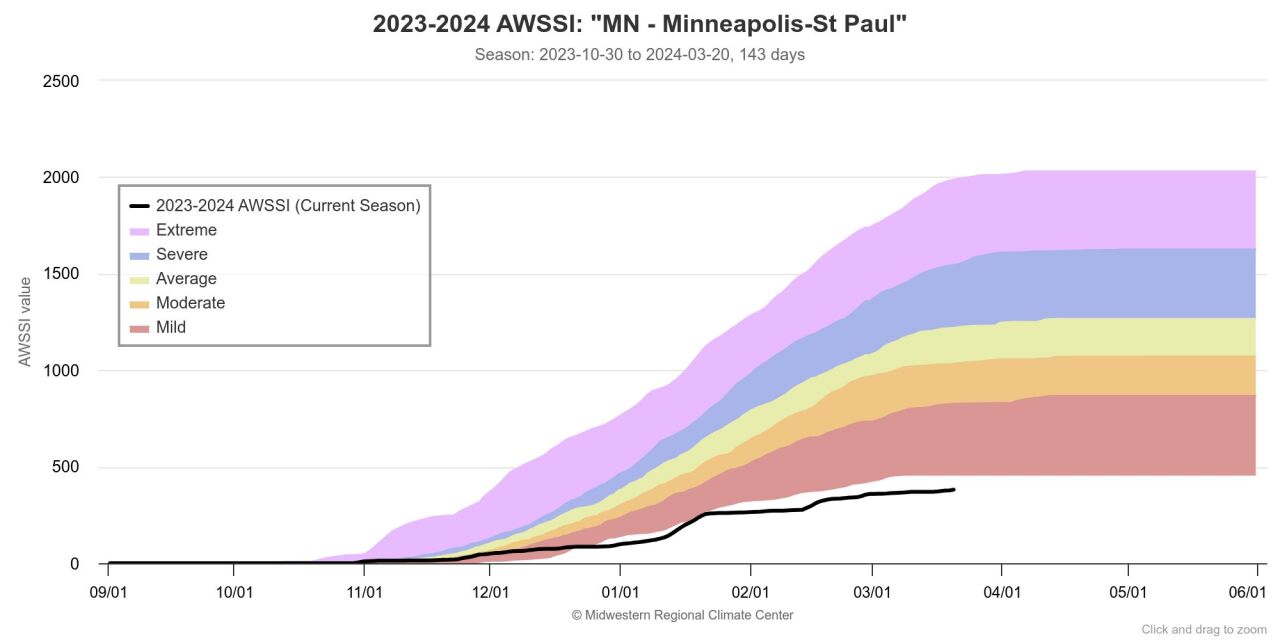
Areas like Minneapolis are currently dealing with a record mild winter, so this system is kind of a "March Miracle" for them.
The Midwest Regional Climate Center (MRCC) uses a winter index called the "Accumulated Winter Season Severity Index" (AWSSI).
This index takes into account the intensity and persistence of cold weather, the amount of snow, and the amount and persistence of snow on the ground.
I wish I could say this graph for Minneapolis was an outlier, but unfortunately much of the northern Midwest is sitting in the same boat.
This winter storm is targeting the upper Midwest nicely, and snow totals should stack up pretty nicely for many cities.
Here in Kansas City, we should stay away from any winter-like precipitation, but I honestly can't rule out a flurries flying for areas northwest of the Kansas City area, especially on the Kansas side.
If we see any winter like precipitation it will be Monday afternoon in to the night.

With snow comes cold air though. And while we have had a mild few weeks, and you may have jumped the gun getting your outside spaces spruced up, here's a heads up for those plants.
Arctic air is sliding south with this system. Montana and North Dakota will be hit the hardest by this but we will see impact as far south as Kansas City.
Temperatures will fall into the 20s by Tuesday morning. This is when the coldest air is looking likely.

Plan to cover up the garden and bring in the plants with this storm system.
While the coldest air settles in Monday night into Tuesday, that's not the only day we are watching for freezes overnight.
Remember the average last freeze in the KC area is around April 10 and keep up with our 10 day forecast to make sure your outside space is protected and don't box up the fuzzy jammies just yet.
—
